New York State Route 301
| ||||
|---|---|---|---|---|
|
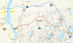
Map of Putnam County in southeastern New York with NY 301 highlighted in red | ||||
| Route information | ||||
| Maintained by NYSDOT | ||||
| Length: | 19.04 mi[1] (30.64 km) | |||
| Existed: | 1930[2] – present | |||
| Major junctions | ||||
| West end: |
| |||
|
| ||||
| East end: |
| |||
| Location | ||||
| Counties: | Putnam | |||
| Highway system | ||||
| ||||

New York State Route 301 (NY 301), also known as the Hudson River Turnpike, is an intra-county state highway stretching across three-quarters of Putnam County, New York, in the United States. The western terminus of NY 301 is at an intersection with NY 9D in Cold Spring. Its eastern terminus is at a junction with NY 52 in Carmel. Along the way, NY 301 meets U.S. Route 9 (US 9) and the Taconic State Parkway and passes through Clarence Fahnestock State Park. The section of the route between NY 9D and US 9 is ceremoniously designated as the Sergeant Albert Ireland Memorial Highway.
NY 301 was assigned as part of the 1930 renumbering of state highways in New York, but only to the portion of its modern alignment west of US 9. At the same time, the section of what is now NY 301 between Kent Cliffs and Carmel became part of New York State Route 130, an east–west route that continued southwest from Kent Cliffs to Peekskill. NY 301 was extended east to Kent Cliffs by 1932 via the Philipstown Turnpike and to Carmel c. 1934 by way of NY 130.
Route description
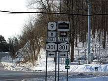
The western terminus of NY 301 is at a four-way junction with NY 9D in Cold Spring. At the intersection, Morris Avenue enters from the north, Chestnut Street comes in from the south, and Main Street enters from the west and leaves to the east on NY 301. The route climbs a hill into the Philipstown village of Nelsonville, where it remains Main Street until transitioning into Cold Spring Carmel Road and passing near the southeast border of the Hudson Highlands State Park. It crosses US 9, locally Albany Post Road, at Mekeel Corners and continues northeast into the woods of the Clarence Fahnestock State Park.[3]
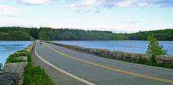
The highway crosses over Clove Creek a few times and turns slightly towards the southeast; however, it soon resumes a northeasterly course as the Cold Spring Turnpike. Continuing through the state park, NY 301 skirts the southern bank of Lake Canopus before crossing the Taconic State Parkway in Putnam Valley. Roughly 3.5 miles (5.6 km) to the northeast at Mead Corners, NY 301 bears southeast toward Carmel. The road passes north of Sagamore Lake to hug the western shore of Boyds Corner Reservoir. Shortly thereafter, NY 301 follows the inside of the western fork of the West Branch Reservoir—part of the Croton Watershed—just southwest of the Nimham Mountain State Forest, before bisecting the body of water via a causeway.[3]
NY 301 ends at NY 52 (Gleneida Avenue) to the north of Lake Gleneida in the county seat of Carmel. Lake Gleneida is a controlled lake, created when an original pond was dammed in 1870, that is part of New York City's water supply system.[4] At the far end of the junction is the Putnam County Courthouse,[3] a National Register of Historic Places-listed structure that was first constructed in 1814.[5] The eastern terminus of NY 301 is just 0.25 miles (0.40 km) north of NY 52's eastern terminus at US 6.[3]
History
Philipstown Turnpike
The portion of modern-day NY 301 west of Meads Corners was originally part of the Philipstown Turnpike. Initially, the county's proximity to the Hudson River supplied cheap means of transporting goods to Albany and New York City, though in the winter months, the river froze over.[6] To resolve the issue, in 1815, the Philipstown Turnpike Company was organized to improve upon a toll road from Cold Spring to the Connecticut border.[7] On April 15, 1815, "an act to incorporate the Philipstown turnpike company in the county of Putnam" was passed.[8] East of the Connecticut border, the turnpike continued as the New Milford and Sherman Turnpike.[9]

On the turnpike, wagons transported manufactures inland, and carried produce from the eastern part of the county.[6] Before the advent of the railroad, the road was a business center for much of the county.[10] One of the intentions of the turnpike was to "greatly promote the public good, as well contribute to their individual interest". However, the turnpike was eventually abandoned, because the tolls received were not sufficient to defray the expense of maintaining the road and associated bridges.[9] The tolls were also inadequate for investors in the Philipstown Turnpike Company to make a profit.[6]
Designation and recent history
NY 301 was assigned as part of the 1930 renumbering of state highways in New York to the portion of its modern alignment west of US 9. At the same time, the section of what is now NY 301 from County Route 21 (CR 21) in Kent Cliffs to NY 52 in Carmel was designated as part of NY 130, which continued southwest from Kent Cliffs to Peekskill via CR 21, Oregon Road, and Division Street.[2] By 1932, NY 301 was extended eastward to NY 130 in Kent Cliffs by way of its modern alignment.[11] NY 130 was replaced by an extended NY 301 from Kent Cliffs to Carmel c. 1934[12][13] and eliminated entirely c. 1938.[14][15]
The section of NY 301 from the vicinity of Kittridge Drive, a local street southeast of Kent Cliffs, to NY 52 was initially county-maintained as CR 47.[16] On April 1, 1980, ownership and maintenance of this section of the route was transferred to the state of New York as part of a highway maintenance swap between the two levels of government.[17] The concurrent CR 47 designation was subsequently eliminated; however, the number was later reused for a 0.2-mile (0.3 km) former alignment of NY 301 in Kent Cliffs.[18]
On August 20, 2002, the portion of NY 301 between NY 9D and US 9 was designated as the "Sergeant Albert Ireland Memorial Highway".[19] The ceremonial designation honors Albert L. Ireland, a U.S. Marine Corps sergeant from Cold Spring who was awarded many citations, including nine Purple Hearts, for his service during World War II and the Korean War.[20][21] In June 2012, the entire roadway was designated as the Hudson River Turnpike by Putnam County with the intent of reminding "drivers of the picturesque landscape and historic areas along its path".[22]
Major intersections
The entire route is in Putnam County.
| Location | mi[1] | km | Destinations | Notes | |
|---|---|---|---|---|---|
| Cold Spring | 0.00 | 0.00 | |||
| Nelsonville | 0.98 | 1.58 | |||
| Philipstown | 2.48 | 3.99 | |||
| Putnam Valley | 8.63 | 13.89 | NY 301 runs along northern town line | ||
| Kent | 11.80 | 18.99 | |||
| 13.91 | 22.39 | Hamlet of Kent Cliffs | |||
| Carmel | 19.04 | 30.64 | |||
| 1.000 mi = 1.609 km; 1.000 km = 0.621 mi | |||||
See also
References
- 1 2 "2008 Traffic Volume Report for New York State" (PDF). New York State Department of Transportation. June 16, 2009. p. 210. Retrieved February 1, 2010.
- 1 2 Road Map of New York (Map). Cartography by General Drafting. Standard Oil Company of New York. 1930.
- 1 2 3 4 Google (September 14, 2012). "overview map of NY 301" (Map). Google Maps. Google. Retrieved September 14, 2012.
- ↑ Nackman, Barbara Livingston (May 13, 2001). "Abundance of boats put damper on $2.3M plan to improve hamlet". The Journal News. White Plains, NY. Retrieved December 24, 2009.
The New York City Department of Environmental Protection is in charge of Lake Gleneida, created in 1870 when the city built a dam to create a controlled lake.
- ↑ Gobrecht, Lawrence (March 23, 1976). "National Register of Historic Places nomination, Putnam County Courthouse". New York State Office of Parks, Recreation and Historic Preservation. Retrieved December 24, 2009.
- 1 2 3 "A Brief History of Putnam County". Putnam County Government. 2008. Retrieved August 24, 2008.
- ↑ Pelletreau, William Smith (1886). History of Putnam County, New York. University of Michigan. p. 519.
- ↑ New York (State) Legislature (1834). Journal of the Assembly of the State of New York. Oxford University: John Shea. p. 449. Retrieved August 24, 2008.
- 1 2 Connecticut, General Assembly (1857). Special Acts and Resolutions of the State of Connecticut ... Case, Lockwood & Brainard. p. 1335. Retrieved August 24, 2008.
- ↑ Goist & Gilbert (2004). "History of Putnam County Chapter XXVII Town of Kent". NYGenWeb. Retrieved August 24, 2008.
- ↑ Texaco Road Map – New York (Map). Cartography by Rand McNally and Company. Texas Oil Company. 1932.
- ↑ Texaco Road Map – New York (Map). Cartography by Rand McNally and Company. Texas Oil Company. 1933.
- ↑ Texaco Road Map – New York (Map). Cartography by Rand McNally and Company. Texas Oil Company. 1934.
- ↑ New York (Map). Cartography by General Drafting. Standard Oil Company. 1937.
- ↑ New York Road Map for 1938 (Map). Cartography by General Drafting. Esso. 1938.
- ↑ Metropolitan New York & Long Island (Map) (1974 ed.). Cartography by Rand McNally and Company. Amoco Oil Company. 1973.
- ↑ New York State Legislature. "New York State Highway Law § 341". Retrieved June 24, 2010.
- ↑ "Putnam County Inventory Listing" (CSV). New York State Department of Transportation. March 2, 2010. Retrieved January 20, 2011.
- ↑ New York State Legislature. "Bills of New York State – bill number-based search (S5082B, 2001)". Retrieved February 5, 2010.
- ↑ "National Affairs: Fighting Man". Time. July 27, 1953. Retrieved June 24, 2010.
- ↑ "Memorial Service for Albert Luke Ireland". Putnam County News and Recorder. Cold Spring, NY. November 10, 2004. Retrieved June 24, 2010.
- ↑ Nackman, Barbara Livingston (June 20, 2012). "Putnam's Route 301 renamed Hudson River Turnpike". The Journal News. White Plains, NY. Retrieved September 14, 2012.
External links
| Wikimedia Commons has media related to New York State Route 301. |
- New York State Route 301 at Alps' Roads • New York Routes • New York State Highway Termini