New Market, Alabama
| New Market, Alabama | |
|---|---|
| CDP | |
 | |
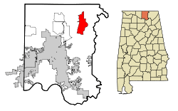 Location in Madison County and the state of Alabama | |
| Coordinates: 34°54′22″N 86°25′34″W / 34.90611°N 86.42611°W | |
| Country | United States |
| State | Alabama |
| County | Madison |
| Area | |
| • Total | 17.5 sq mi (45.4 km2) |
| • Land | 17.5 sq mi (45.4 km2) |
| • Water | 0 sq mi (0 km2) |
| Elevation | 758 ft (231 m) |
| Population (2010) | |
| • Total | 1,597 |
| • Density | 91/sq mi (35/km2) |
| Time zone | Central (CST) (UTC-6) |
| • Summer (DST) | CDT (UTC-5) |
| ZIP code | 35761 |
| Area code(s) | 256 |
| FIPS code | 01-54312 |
| GNIS feature ID | 0155175 |
New Market is a census-designated place (CDP) in Madison County, Alabama, United States, and is included in the Huntsville-Decatur Combined Statistical Area. As of the 2010 census, the population of the CDP is 1,597.[1] Although it was the first area settled in Madison County, the town has never been incorporated.
History
In the early 19th century, several persons from Tennessee explored the area just across the border in what eventually became Madison County in Alabama. Isaac and Joseph Criner also explored the area and, in 1804, settled in the northern part near what is now called Mountain Fork of the Flint River. Later settlers gave the name New Market to the community.[2]
On January 30, 1966, the coldest temperature ever to be recorded in Alabama was registered in New Market, at -27 °F.
Four sites in New Market are listed on the National Register of Historic Places: the New Market Historic District, New Market Presbyterian Church, New Market United Methodist Church, and the Whitman-Cobb House.[3]
Geography
New Market is located at 34°54′23″N 86°25′34″W / 34.90639°N 86.42611°W (34.906295, -86.426170).[4]
According to the U.S. Census Bureau, the CDP has a total area of 17.5 square miles (45 km2), all land.
Demographics
| Historical population | |||
|---|---|---|---|
| Census | Pop. | %± | |
| 1880 | 144 | — | |
| 1990 | 1,094 | — | |
| 2000 | 1,864 | 70.4% | |
| 2010 | 1,597 | −14.3% | |
| U.S. Decennial Census | |||
New Market first appeared on the 1880 U.S. Census as an unincorporated community of 144 residents. It did not appear again on the census for 110 years until 1990, when it was classified as a census-designated place (CDP).
As of the census[5] of 2000, there were 1,864 people, 692 households, and 534 families residing in the CDP. The population density was 108.4 people per square mile (41.8/km²). There were 787 housing units at an average density of 45.8 per square mile (17.7/km²). The racial makeup of the CDP was 87.18% White, 6.28% Black or African American, 2.25% Native American, 0.16% Asian, 1.34% from other races, and 2.79% from two or more races. 3.54% of the population were Hispanic or Latino of any race.
There were 692 households out of which 38.0% had children under the age of 18 living with them, 61.7% were married couples living together, 10.8% had a female householder with no husband present, and 22.8% were non-families. 19.1% of all households were made up of individuals and 6.8% had someone living alone who was 65 years of age or older. The average household size was 2.67 and the average family size was 3.05.
In the CDP the population was spread out with 26.1% under the age of 18, 8.3% from 18 to 24, 35.2% from 25 to 44, 19.5% from 45 to 64, and 10.9% who were 65 years of age or older. The median age was 35 years. For every 100 females there were 101.3 males. For every 100 females age 18 and over, there were 101.3 males.
The median income for a household in the CDP was $42,985, and the median income for a family was $46,696. Males had a median income of $36,204 versus $18,188 for females. The per capita income for the CDP was $18,799. About 7.5% of families and 11.2% of the population were below the poverty line, including 14.7% of those under age 18 and 7.8% of those age 65 or over.
2010 census
As of the census[6] of 2010, there were 1,597 people, 632 households, and 454 families residing in the CDP. The population density was 91 people per square mile (35/km²). There were 714 housing units at an average density of 40.8 per square mile (15.7/km²). The racial makeup of the CDP was 88.5% White, 6.7% Black or African American, 1.4% Native American, 0.2% Asian, 1.9% from other races, and 1.3% from two or more races. 4.4% of the population were Hispanic or Latino of any race.
There were 632 households out of which 28.6% had children under the age of 18 living with them, 56.3% were married couples living together, 10.4% had a female householder with no husband present, and 28.2% were non-families. 23.6% of all households were made up of individuals and 7.6% had someone living alone who was 65 years of age or older. The average household size was 2.53 and the average family size was 3.00.
In the CDP the population was spread out with 22.9% under the age of 18, 9.3% from 18 to 24, 24.3% from 25 to 44, 31.3% from 45 to 64, and 12.3% who were 65 years of age or older. The median age was 41.1 years. For every 100 females there were 101.9 males. For every 100 females age 18 and over, there were 106.4 males.
The median income for a household in the CDP was $42,857, and the median income for a family was $51,250. Males had a median income of $36,250 versus $27,068 for females. The per capita income for the CDP was $22,043. About 11.9% of families and 14.6% of the population were below the poverty line, including 35.3% of those under age 18 and 21.1% of those age 65 or over.
Public Services
Water service in the New Market area is run by the Madison County Water Authority. Sewer service is unavailable. Huntsville Utilities provides electric service.
The Madison County Sheriff's Department administers law and order in the community, and the New Market Volunteer Fire Department provides fire protection.
Education
New Market is home to several schools run by the Madison County School System.
K-8 Schools
- New Market School
- Walnut Grove Elementary School
Middle Schools
- Buckhorn Middle School
High Schools
Notable people
- Joe W. Davis, mayor of Huntsville from 1968 to 1988
- Woodall Rodgers, mayor of Dallas, Texas from 1939 to 1947
- Sam Streeter, baseball pitcher in the Negro Leagues from 1920 to 1936
- T. T. Terry, first mayor of Huntsville, serving from 1916 to 1918
- Holly Helms, Female Vocalist of The Springs (band)
References
- ↑ "American FactFinder". United States Census Bureau. Retrieved 2011-05-14.
- ↑ Taylor, James Jones; The History of Madison County, handwritten 1880-1886, transcribed and bound for the Huntsville-Madison County Library, 1940
- ↑ National Park Service (July 9, 2010). "National Register Information System". National Register of Historic Places. National Park Service. Retrieved July 15, 2014.
- ↑ "US Gazetteer files: 2010, 2000, and 1990". United States Census Bureau. 2011-02-12. Retrieved 2011-04-23.
- ↑ "American FactFinder". United States Census Bureau. Retrieved 2008-01-31.
- ↑ "American FactFinder". United States Census Bureau. Retrieved 2015-08-02.
External links
 Media related to New Market, Alabama at Wikimedia Commons
Coordinates: 34°54′23″N 86°25′34″W / 34.906295°N 86.42617°W
Municipalities and communities of Madison County, Alabama, United States | ||
|---|---|---|
| Cities | 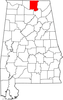 | |
| Towns | ||
| CDPs | ||
| Unincorporated communities | ||
| Footnotes | ‡This populated place also has portions in an adjacent county or counties | |