New Lower Inn Valley railway
| New Lower Inn Valley railway | ||||||||||||||||||||||||||||||||||||||||||||||||||||||||||||||||||||||||||||||||||||||||||||||||||||||||||||||||||||||||||||||||||||||||||||||||||||||||||||||||||||||||||||||||||||||||||||||||||||||||||||
|---|---|---|---|---|---|---|---|---|---|---|---|---|---|---|---|---|---|---|---|---|---|---|---|---|---|---|---|---|---|---|---|---|---|---|---|---|---|---|---|---|---|---|---|---|---|---|---|---|---|---|---|---|---|---|---|---|---|---|---|---|---|---|---|---|---|---|---|---|---|---|---|---|---|---|---|---|---|---|---|---|---|---|---|---|---|---|---|---|---|---|---|---|---|---|---|---|---|---|---|---|---|---|---|---|---|---|---|---|---|---|---|---|---|---|---|---|---|---|---|---|---|---|---|---|---|---|---|---|---|---|---|---|---|---|---|---|---|---|---|---|---|---|---|---|---|---|---|---|---|---|---|---|---|---|---|---|---|---|---|---|---|---|---|---|---|---|---|---|---|---|---|---|---|---|---|---|---|---|---|---|---|---|---|---|---|---|---|---|---|---|---|---|---|---|---|---|---|---|---|---|---|---|---|---|
 | ||||||||||||||||||||||||||||||||||||||||||||||||||||||||||||||||||||||||||||||||||||||||||||||||||||||||||||||||||||||||||||||||||||||||||||||||||||||||||||||||||||||||||||||||||||||||||||||||||||||||||||
| Overview | ||||||||||||||||||||||||||||||||||||||||||||||||||||||||||||||||||||||||||||||||||||||||||||||||||||||||||||||||||||||||||||||||||||||||||||||||||||||||||||||||||||||||||||||||||||||||||||||||||||||||||||
| Native name | Neue Unterinntalbahn | |||||||||||||||||||||||||||||||||||||||||||||||||||||||||||||||||||||||||||||||||||||||||||||||||||||||||||||||||||||||||||||||||||||||||||||||||||||||||||||||||||||||||||||||||||||||||||||||||||||||||||
| Locale | Austria | |||||||||||||||||||||||||||||||||||||||||||||||||||||||||||||||||||||||||||||||||||||||||||||||||||||||||||||||||||||||||||||||||||||||||||||||||||||||||||||||||||||||||||||||||||||||||||||||||||||||||||
| Line number | 330 01 | |||||||||||||||||||||||||||||||||||||||||||||||||||||||||||||||||||||||||||||||||||||||||||||||||||||||||||||||||||||||||||||||||||||||||||||||||||||||||||||||||||||||||||||||||||||||||||||||||||||||||||
| Technical | ||||||||||||||||||||||||||||||||||||||||||||||||||||||||||||||||||||||||||||||||||||||||||||||||||||||||||||||||||||||||||||||||||||||||||||||||||||||||||||||||||||||||||||||||||||||||||||||||||||||||||||
| Line length | 40.236 km (25.001 mi) | |||||||||||||||||||||||||||||||||||||||||||||||||||||||||||||||||||||||||||||||||||||||||||||||||||||||||||||||||||||||||||||||||||||||||||||||||||||||||||||||||||||||||||||||||||||||||||||||||||||||||||
| Number of tracks | 2 | |||||||||||||||||||||||||||||||||||||||||||||||||||||||||||||||||||||||||||||||||||||||||||||||||||||||||||||||||||||||||||||||||||||||||||||||||||||||||||||||||||||||||||||||||||||||||||||||||||||||||||
| Track gauge | 1,435 mm (4 ft 8 1⁄2 in) standard gauge | |||||||||||||||||||||||||||||||||||||||||||||||||||||||||||||||||||||||||||||||||||||||||||||||||||||||||||||||||||||||||||||||||||||||||||||||||||||||||||||||||||||||||||||||||||||||||||||||||||||||||||
| Electrification | 15 kV/16.7 Hz AC overhead catenary | |||||||||||||||||||||||||||||||||||||||||||||||||||||||||||||||||||||||||||||||||||||||||||||||||||||||||||||||||||||||||||||||||||||||||||||||||||||||||||||||||||||||||||||||||||||||||||||||||||||||||||
| Operating speed | 220 km/h (136.7 mph) (maximum) | |||||||||||||||||||||||||||||||||||||||||||||||||||||||||||||||||||||||||||||||||||||||||||||||||||||||||||||||||||||||||||||||||||||||||||||||||||||||||||||||||||||||||||||||||||||||||||||||||||||||||||
| Route number | 300 | |||||||||||||||||||||||||||||||||||||||||||||||||||||||||||||||||||||||||||||||||||||||||||||||||||||||||||||||||||||||||||||||||||||||||||||||||||||||||||||||||||||||||||||||||||||||||||||||||||||||||||
| ||||||||||||||||||||||||||||||||||||||||||||||||||||||||||||||||||||||||||||||||||||||||||||||||||||||||||||||||||||||||||||||||||||||||||||||||||||||||||||||||||||||||||||||||||||||||||||||||||||||||||||
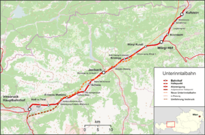
The New Lower Inn Valley railway (German: Neue Unterinntalbahn) is a partially completed double-track high-speed main line of the Austrian railways. It connects the Brenner railway at Innsbruck and the Innsbruck bypass with the line to Kufstein, connecting with Germany, Salzburg and eastern Austria. It forms a part the core of the network of Austrian Federal Railways (ÖBB). The bypass is part of Line 1 of the Trans-European Transport Networks (TEN-T). The first section (Kundl–Baumkirchen), which is designed for speeds up to 220 km/h, was opened on 26 November 2012.[2] Since the timetable change on 9 December 2012, it relieves the existing Lower Inn Valley railway between Wörgl and Baumkirchen with trains able to operate at up to 250 km/h. In the future, these and other construction projects (including the Brenner Base Tunnel) are expected to reduce travel time on the Munich-Innsbruck route from 1:50 to 0:55 and on the Munich–Verona route from 5:20 to 2:20.[3] The cost of the project amounted to € 2.358 billion.[4]
History
The Kundl–Baumkirchen section was opened on 26 December 2012.
Route: section 1: Kundl-Baumkirchen

The line is 40 km long, of which approximately 32 km is in tunnels or deep cuttings. The section between Wörgl Kundl station and the original line is supplemented with a high-speed line and forms a four-track line to a grade-separated junction at Radfeld. The new segment then descends between the tracks of the existing line and runs to the almost 16 kilometre-long Münsterer tunnel. After passing under the Inn and Jenbach railway station it continues to the grade-separated junction at Stans. The line descends again, and continues through the 15.8 kilometre-long Terfner tunnel. In the tunnel there is space for a planned third track to allow overtaking movements, thus increasing line capacity. After underpassing the Fritzens-Wattens station it joins the old line at Baumkirchen where it separates towards Brenner/Verona via the Innsbruck bypass or towards Innsbruck/Arlberg via the original line.[5]
Signalling
The new line is fitted with ETCS Level 2 signalling system. Four new electronic interlocking systems were built to control both the new line and the existing line. These systems are remotely controlled from the new Innsbruck operations control centre (Betriebsfernsteuerzentrale).[6]
Planning: section 2: Brannenburg-Kundl
The approximately 25 kilometre-long section from Brannenburg-Kundl is currently in the planning phase with route selection between Schaftenau and Kundl has been completed. The continuation of the route into Germany is currently being negotiated.[7]
The selected route south from Schaftenau would leave the existing line via several short tunnels and cuttings to join the route of the A12 autobahn. It would then run through a nearly 10 kilometre-long tunnel under the mountains of the southern Angerbergs and under the Inn, the A12 and the built-up areas of Kundl before emerging between the tracks of the existing line and running to the grade-separated junction at Radfeld.[8]
References
- ↑ Eisenbahnatlas Österreich (Austrian railway atlas). Schweers + Wall. 2010. ISBN 978-3-89494-138-3.
- ↑ "Neue Unterinntalbahn: Highspeed und höchste Sicherheit" (PDF) (Press release) (in German). ÖBB-Holding AG. 26 November 2012. Retrieved 31 January 2013.
- ↑ Brenner Eisenbahn GmbH, ed. (October 2007). "Die neue Unterinntalbahn - Eisenbahntechnik auf höchstem Niveau" (PDF) (in German). Retrieved 31 January 2013.
- ↑ "Die letzte Schiene ist verlegt". Tiroler Tageszeitung (in German). 16 December 2011. Retrieved 31 January 2013.
- ↑ "Section 1 route map" (PDF) (in German). Brenner Eisenbahn GmbH. Retrieved 13 February 2010.
- ↑ "Eisenbahnsicherungstechnik" (in German). ÖBB-Infrastruktur AG. Retrieved 31 January 2013.
- ↑ "Trassenauswahlverfahren für zweiten Abschnitt der neuen Unterinntalbahn abgeschlossen (Route selection process for the second section of the new Lower Inn Valley railway completed)" (in German). Austrian Federal Railways. Retrieved 13 February 2010.
- ↑ "Section 2 route map" (PDF) (in German). Brenner Eisenbahn GmbH. Retrieved 13 February 2010.
| Wikimedia Commons has media related to Lower Inn Valley railway. |
Coordinates: 47°25′43″N 11°53′43″E / 47.42861°N 11.89528°E