New Jersey Route 52
| ||||
|---|---|---|---|---|
 | ||||
| Route information | ||||
| Maintained by NJDOT | ||||
| Length: | 2.74 mi[1] (4.41 km) | |||
| Existed: | 1937 – present | |||
| Major junctions | ||||
| South end: | 9th Street in Ocean City | |||
|
| ||||
| North end: |
| |||
| Location | ||||
| Counties: | Cape May, Atlantic | |||
| Highway system | ||||
| ||||

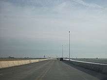
Route 52 is a state highway in the southern part of the U.S. state of New Jersey. The highway runs 2.74 mi (4.41 km) from 9th Street in Ocean City, Cape May County north to U.S. Route 9 (New Road) in Somers Point, Atlantic County. It is composed mostly of a series of four-lane undivided bridges over Great Egg Harbor Bay from Ocean City to Somers Point known as the Howard S. Stainton Memorial Causeway, also known as the Ninth Street Bridge. The remainder of the route is a four-lane undivided surface road called MacArthur Boulevard that runs from the causeway to U.S. Route 9. This section of the route formerly included the Somers Point Circle, now a traffic light, where Route 52 intersects County Route 559 and County Route 585.
Route 52 was originally designated in 1937 to run from the Somers Point Circle northwest to Mays Landing. This routing never came about and in 1953, Route 52 was designated onto its current alignment. County Route 585 ran concurrent with the route south of the Somers Point Circle until 1971, when it was truncated to end at the Somers Point Circle. The circle was removed in 2010 as part of the bridge reconstruction. In 2006, construction began on the replacement of the Route 52 causeway that was built in the 1930s over the Great Egg Harbor Bay, beginning with guardrail repairs that reduced traffic to two lanes. In 2008, the northbound lanes of the causeway were opened to traffic. Construction on the southbound lanes was completed in late 2009. The entire project was completed in 2012, including other improvements such as the construction of fishing piers, boat ramps, bike paths, walking trails, gateways, and a new Ocean City Visitor Center. In addition, improvements were made to MacArthur Boulevard that include the addition of a center left-turn lane and the replacement of the Somers Point Circle with a traffic light. This project received $70 million from the stimulus bill signed into law by President Barack Obama in 2009.
Route description
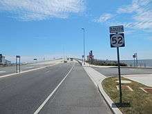
Route 52 begins along Ninth Street in Ocean City, Cape May County, 0.01 miles (0.016 km) south of Palen Avenue. Past the southern terminus of Route 52, 9th Street heads southeast and terminates at Ocean City’s boardwalk along the Atlantic Ocean. From the beginning of state maintenance, the route continues to the northwest as a four-lane, undivided road.[1][2] Immediately after beginning, Route 52 becomes the Howard S. Stainton Memorial Causeway, also known as the Ninth Street Bridge, which crosses over Great Egg Harbor Bay on a high-level bridge and then the longer Rainbow Harbor Channel. In between these two channels is an island where the Ocean City Visitor Center is located. After crossing the Rainbow Harbor Channel, the road runs along another island before crossing over the Great Egg Harbor Thoroughfare (part of the Intracoastal Waterway) and then a ship channel on another high-level bridge, where the route enters Somers Point in Atlantic County.[1][2]
After the ship canal, Route 52 crosses onto the mainland and intersects with County Route 559 (Mays Landing Road) and County Route 585 (Shore Road), formerly at the Somers Point traffic circle.[1] In October 2010, the circle was eliminated and replaced by a traffic light.[3] Beyond the former Somers Point Circle, Route 52 becomes a two-lane road known as MacArthur Boulevard that heads north through commercial areas before entering residential areas.[2] Route 52 comes to an end at an intersection with U.S. Route 9 (New Road), where the road continues northwest as West Laurel Drive, which heads through a residential neighborhood to an interchange with the Garden State Parkway.[1][2]
History
The causeway between Ocean City and Somers Point was built in the 1930s with four lanes and no shoulders.[4] Route 52 was designated 1937 to run from the Somers Point Circle northwest to Route 48 (now U.S. Route 40) and Route 50 in Mays Landing.[5] However, Route 52 was never built to run to Mays Landing.[6] In the 1953 New Jersey state highway renumbering, Route 52 was designated to run from the Ocean City side of the Great Egg Harbor causeway north to U.S. Route 9 in Somers Point.[7] With the creation of the 500-series county routes in New Jersey in 1952, County Route 585 was designated to run along Route 52 between the southern terminus and the Somers Point Circle as part of its route between Route 109 in Lower Township and U.S. Route 30 and Route 157 in Absecon.[8] Eventually, the southern terminus of County Route 585 was truncated to the Somers Point Circle.[1]
Between 2006 and 2012, a new $400 million causeway was built to replace the 1930s bridges over the Great Egg Harbor Bay. The original causeway was in need of replacement due to deteriorating conditions of the bridges, increasing automobile and marine traffic on the Great Egg Harbor Bay, flooding from storms, and a high accident rate due to narrow lanes and a lack of shoulders.[9] The causeway also contained two drawbridges, which led to traffic jams during the summer months.[10] On January 16, 2006, the New Jersey Department of Transportation reduced traffic on the existing bridges from four lanes to two lanes to limit the weight on the old structures. The highway was reopened to four lanes of traffic after guardrail repairs were made on May 17, 2006, with a new speed limit of 35 mph (56 km/h).[11] After years of delays, construction began on the new bridge in September 2006. Crews began the project by clearing a staging area on Garrets Island near the Ocean City side.[12] The northbound bridge was completed in April 2008 and the southbound bridge was completed in April 2009.[4][13][14] In May 2012, construction of the causeway was completed, with all four lanes opened to traffic.[10]
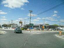
In addition to the new causeway, the project also called for the construction of fishing piers, boat ramps, bike paths, walking trails, and gateways at each end of the causeway, including a new visitor center with a scenic overlook on the Ocean City side.[4] Also, other improvements were made to the MacArthur Boulevard portion of Route 52 including the addition of a center left-turn lane and the replacement of the Somers Point Circle with a traffic light, which was eliminated in October 2010.[3][4][9] As a result of the stimulus bill signed into law by President Barack Obama on February 17, 2009, $70 million, or about 8 percent of the money allocated to New Jersey in the bill, went to the construction of the second half of the Route 52 causeway project.[15]
Major intersections
| County | Location | mi[1] | km | Destinations | Notes |
|---|---|---|---|---|---|
| Cape May | Ocean City | 0.00 | 0.00 | 9th Street | Southern terminus; continues as 9th Street |
| Great Egg Harbor Bay | 0.15– 1.91 | 0.24– 3.07 | Howard S. Stainton Memorial Causeway | ||
| Atlantic | Somers Point | 2.11 | 3.40 | Former Somers Point Circle | |
| 2.74 | 4.41 | Northern terminus; continues as Laurel Drive | |||
| 1.000 mi = 1.609 km; 1.000 km = 0.621 mi | |||||
See also
 U.S. Roads portal
 New Jersey portal
References
- 1 2 3 4 5 6 7 "New Jersey Route 52 straight line diagram" (PDF). New Jersey Department of Transportation. Retrieved 2009-03-09.
- 1 2 3 4 Google (2009-03-09). "overview of New Jersey Route 52" (Map). Google Maps. Google. Retrieved 2009-03-09.
- 1 2 Good, Dan (2010-10-18). "Local restaurants could lose business, as construction crews eliminate Somers Point traffic circle". Press of Atlantic City. Retrieved 2010-11-08.
- 1 2 3 4 Urgo, Jacqueline L. (February 10, 2008). "Bottleneck at Shore will be a breeze". The Philadelphia Inquirer.
- ↑ State of New Jersey, Laws of 1937, Chapter 86.
- ↑ Map of Pennsylvania and New Jersey (Map). Cartography by H.M. Gousha. Mid-West Map Co. 1941. Retrieved 2009-03-28.
- ↑ "1953 renumbering". New Jersey Department of Highways. Retrieved July 31, 2009.
- ↑ Map of New Jersey (Map). Cartography by H.M. Gousha. Chevron Oil Company. 1969.
- 1 2 "Route 52 Causeway Bridge Replacement, Frequently Asked Questions, Construction Updates, Commuter Information". New Jersey Department of Transportation. Retrieved 2009-03-09.
- 1 2 Urgo, Jacqueline L. (May 17, 2012). "Route 52 Causeway ready for the season in Ocean City, N.J.". The Philadelphia Inquirer. Retrieved May 18, 2012.
- ↑ "NJDOT doubles capacity of Route 52 Causeway". New Jersey Department of Transportation. May 17, 2006. Retrieved 2009-03-09.
- ↑ Miller, Michael (September 26, 2006). "Five-year job to cost $400 million". Press of Atlantic City.
- ↑ "NJDOT announces Route 52 Causeway southbound lane closure". New Jersey Department of Transportation. September 12, 2008. Retrieved 2009-03-09.
- ↑ "NJDOT breaks ground on second phase of Route 52 Causeway replacement in Ocean City and Somers Point". New Jersey Department of Transportation. September 30, 2009. Retrieved 2010-06-21.
- ↑ Miller, Michael (March 7, 2009). "Slow economy may drop Route 52 causeway cost". Press of Atlantic City.
External links
| Wikimedia Commons has media related to New Jersey Route 52. |
- Route 52 Causeway Bridge Replacement Overview, New Jersey Department of Transportation
- Speed Limits for Route 52
- Route 52 Bridge Construction: Updates & Photos
| Crossings of the Great Egg Harbor | ||||
|---|---|---|---|---|
| ||||