New Hampshire Route 151
| ||||
|---|---|---|---|---|
|
Map of Rockingham County in southeastern New Hampshire with NH 151 highlighted in red | ||||
| Route information | ||||
| Maintained by NHDOT | ||||
| Length: | 6.370 mi[1] (10.252 km) | |||
| Major junctions | ||||
| South end: |
| |||
|
| ||||
| North end: |
| |||
| Location | ||||
| Counties: | Rockingham | |||
| Highway system | ||||
| ||||

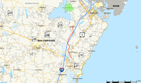
New Hampshire Route 151 (abbreviated NH 151) is a 6.370-mile-long (10.252 km) north–south highway in Rockingham County in southeastern New Hampshire. The road runs between North Hampton and Greenland. NH 151 is locally named Post Road. For most of its length, NH 151 parallels Interstate 95, but there are no interchanges with I-95.
The southern terminus of NH 151 is at U.S. Route 1 (Lafayette Road) in North Hampton. The northern terminus is at New Hampshire Route 33 near the Pease International Tradeport in Greenland.
Major intersections
The entire route is in Rockingham County. [1][2]
| Location[1][2] | mi[1][2] | km | Destinations | Notes | |
|---|---|---|---|---|---|
| Hampton | 0.000 | 0.000 | Southern terminus | ||
| North Hampton | 1.464 | 2.356 | Brief concurrency southbound with NH 111 | ||
| Greenland | 6.370 | 10.252 | Northern terminus | ||
| 1.000 mi = 1.609 km; 1.000 km = 0.621 mi | |||||
References
- 1 2 3 4 Bureau of Planning & Community Assistance (February 20, 2015). "NH Public Roads". Concord, New Hampshire: New Hampshire Department of Transportation. Retrieved April 7, 2015.
- 1 2 3 Bureau of Planning & Community Assistance (April 3, 2015). "Nodal Reference 2015, State of New Hampshire". New Hampshire Department of Transportation. Retrieved April 7, 2015.
External links
This article is issued from Wikipedia - version of the 4/19/2015. The text is available under the Creative Commons Attribution/Share Alike but additional terms may apply for the media files.