New Hampshire Route 103
| ||||
|---|---|---|---|---|
|
Map of western New Hampshire with NH 103 highlighted in red | ||||
| Route information | ||||
| Maintained by NHDOT | ||||
| Length: | 48.300 mi[1] (77.731 km) | |||
| Major junctions | ||||
| West end: |
| |||
| East end: |
| |||
| Location | ||||
| Counties: | Sullivan, Merrimack | |||
| Highway system | ||||
| ||||

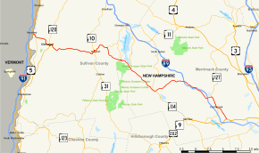
New Hampshire Route 103 (abbreviated NH 103) is a 48.300-mile-long (77.731 km) east–west highway in west-central New Hampshire, United States. The highway runs from Claremont, at the Vermont border on the Connecticut River, to Hopkinton, west of Concord.
The western terminus of NH 103 is in Claremont at the New Hampshire–Vermont state line on the Connecticut River, running concurrently with New Hampshire Route 12. After intersecting with New Hampshire Route 12A, the road continues eastward for 3.793 miles (6.104 km) into the center of Claremont, where NH 103 splits off from NH 12 and merges with New Hampshire Route 11. The highway then runs eastward merged with NH 11 for a distance of 12.991 miles (20.907 km). The road splits off from NH 11 east of Newport. Northwest of Hopkinton, the road runs merged with New Hampshire Route 127 for a distance of 2.127 miles (3.423 km). The eastern terminus of NH 103 is in Hopkinton at U.S. Route 202 and New Hampshire Route 9.
Major intersections
| County | Location[1][2] | mi[1][2] | km | Destinations | Notes |
|---|---|---|---|---|---|
| Sullivan | Claremont | 0.000 | 0.000 | Western terminus; western end of concurrency with NH 12/NH 103 concurrency | |
| 0.545 | 0.877 | ||||
| 4.338 | 6.981 | Opera House Square; eastern end of concurrency with NH 12; western end of concurrency with NH 11 | |||
| 4.543 | 7.311 | Southern terminus of NH 120 | |||
| Newport | 13.950 | 22.450 | Western end of concurrency with NH 10 | ||
| 14.181 | 22.822 | Eastern end of concurrency with NH 10 | |||
| Sunapee | 17.327 | 27.885 | Village of Wendell; eastern end of concurrency with NH 11 | ||
| Merrimack | Newbury | 21.169 | 34.068 | Southern terminus of NH 103B | |
| 23.758 | 38.235 | Southern terminus of NH 103A | |||
| Bradford | 29.959 | 48.214 | |||
| Warner | 36.278– 36.619 | 58.384– 58.933 | Exit 9 on I-89 | ||
| 39.205 | 63.094 | Exit 8 on I-89; exit to I-89 south and entrance from I-89 north | |||
| 41.933– 42.412 | 67.485– 68.255 | Exit 7 on I-89 | |||
| 43.091 | 69.348 | Village of Davisville; western end of concurrency with NH 127 | |||
| Hopkinton | 45.218 | 72.771 | Village of Contoocook; eastern end of concurrency with NH 127 | ||
| 48.300 | 77.731 | Eastern terminus | |||
1.000 mi = 1.609 km; 1.000 km = 0.621 mi
| |||||
Suffixed routes
New Hampshire Route 103A
| |
|---|---|
| Location: | Newbury–New London |
| Length: | 7.720 mi[1] (12.424 km) |
New Hampshire Route 103A (abbreviated NH 103A) is a 7.720-mile-long (12.424 km) secondary north–south highway in Merrimack County, New Hampshire. NH 103A connects New London with Newbury. NH 103A runs down the entire length of the east side of Lake Sunapee and provides access to the local roads along the lakeshore. NH 103A is locally named Lakeside Road.
The southern terminus of NH 103A is at New Hampshire Route 103 at the south end of the lake. The northern terminus is at New Hampshire Route 11, Newport Road, at the north end of the lake near Interstate 89.
New Hampshire Route 103B
| |
|---|---|
| Location: | Newbury–Sunapee |
| Length: | 3.441 mi[1] (5.538 km) |
New Hampshire Route 103B (abbreviated NH 103B) is a 3.441-mile-long (5.538 km) secondary north–south highway located predominantly in Sullivan County (with a small segment in Merrimack County) in western New Hampshire. NH 103B connects Newbury with Sunapee. NH 103B runs along the western shore of Lake Sunapee and provides access to the local roads along the lakeshore. NH 103B is locally named Edgemont Road.
The southern terminus of NH 103B is at New Hampshire Route 103 on the southwest side of the lake. The road runs north into the village of Sunapee about midway up the west side of the lake. The northern terminus of NH 103B is at the junction with New Hampshire Route 11 in the village center.
References
- 1 2 3 4 5 Bureau of Planning & Community Assistance (February 20, 2015). "NH Public Roads". Concord, New Hampshire: New Hampshire Department of Transportation. Retrieved April 7, 2015.
- 1 2 Bureau of Planning & Community Assistance (April 3, 2015). "Nodal Reference 2015, State of New Hampshire". New Hampshire Department of Transportation. Retrieved April 7, 2015.