Nevada State Route 267
| ||||
|---|---|---|---|---|
| Scotty's Castle Road | ||||
 | ||||
| Route information | ||||
| Maintained by NDOT | ||||
| Length: | 21.425 mi[1] (34.480 km) | |||
| Existed: | 1976 – present | |||
| Major junctions | ||||
| West end: | California state line | |||
| East end: |
| |||
| Location | ||||
| Counties: | Esmeralda, Nye | |||
| Highway system | ||||
| ||||

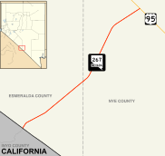
State Route 267 (SR 267) is a 21.425-mile (34.480 km) state highway in Nevada, United States. Known as Scotty's Castle Road, the highway connects Death Valley National Park to U.S. Route 95. The route was previously designated State Route 72.
Route description
_in_Scotty's_Junction%2C_Nevada.jpg)
SR 267 is a continuation of Scotty's Castle Road within Death Valley National Park. The route begins just east of Scotty's Castle, at the California–Nevada state line in Esmeralda County. The highway travels northeast from there, entering Nye County as it traverses the desert. SR 267 reaches its northern terminus at Scotty's Junction, an intersection with US 95 approximately 30 miles (48 km) south of Goldfield.
History

Scotty's Castle Road first appears as an unimproved County road in 1932 edition of the state highway map, connecting State Route 5 (now US 95) to Death Valley via the town of Bonnie Claire.[2] The road was designated State Route 72 by 1942,[3] and had been paved by 1952.[4]
State Route 267 was assigned to former SR 72 on July 1, 1976.[5] This change first appeared on official state maps in 1978.[6]
Major intersections
- Note: Mileposts in Nevada reset at county lines; the start and end mileposts for each county are given in the county column.
| County | Location | mi[7] | km | Destinations | Notes |
|---|---|---|---|---|---|
| Esmeralda 0.00-9.35 | | 0.00 | 0.00 | North Highway – Scotty's Castle | Death Valley National Park border; California state line |
| Nye 0.00-12.07 | Scotty's Junction | 12.07 | 19.42 | ||
| 1.000 mi = 1.609 km; 1.000 km = 0.621 mi | |||||
See also
 Nevada portal
 U.S. Roads portal
References
- ↑ Nevada Department of Transportation (January 2016). "Nevada State Maintained Highways: Descriptions and Maps". Retrieved September 18, 2016.
- ↑ Road Map of the State of Nevada (Map). Nevada State Highway Department. 1932. Retrieved January 11, 2009.
- ↑ Official Road Map of the State of Nevada (Map). Nevada State Highway Department. 1942. Retrieved January 11, 2009.
- ↑ Official Highway Map of Nevada (Map). Nevada Department of Highways. 1952. § G4. Retrieved January 11, 2009.
- ↑ Nevada State Maintained Highways: Descriptions, Index and Maps. Nevada Department of Transportation. January 2001. p. 104.
- ↑ Official Highway Map of Nevada (Map) (1978-79 ed.). Nevada State Highway Department. 1978. § E2. Retrieved January 11, 2009.
- ↑ Nevada Department of Transportation (May 2008). "Maps of Milepost Location on Nevada's Federal and State Highway System by County" (PDF). Retrieved January 11, 2009.