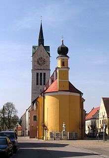
Neustadt an der Donau
| Neustadt a.d.Donau | ||
|---|---|---|
| ||
 Neustadt a.d.Donau | ||
Location of Neustadt a.d.Donau within Kelheim district 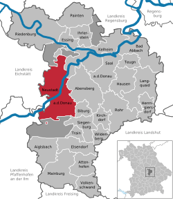 | ||
| Coordinates: 48°48′N 11°46′E / 48.800°N 11.767°ECoordinates: 48°48′N 11°46′E / 48.800°N 11.767°E | ||
| Country | Germany | |
| State | Bavaria | |
| Admin. region | Niederbayern | |
| District | Kelheim | |
| Government | ||
| • Mayor | Thomas Reimer (SPD) | |
| Area | ||
| • Total | 93.57 km2 (36.13 sq mi) | |
| Population (2015-12-31)[1] | ||
| • Total | 13,670 | |
| • Density | 150/km2 (380/sq mi) | |
| Time zone | CET/CEST (UTC+1/+2) | |
| Postal codes | 93333 | |
| Dialling codes |
09445 09444 (Mühlhausen) 08402 (Schwaig, Umbertshausen) | |
| Vehicle registration | KEH | |
| Website | www.neustadt-donau.de | |

- Neustadt an der Donau is also the German translation of Dunaújváros in Hungary.
Neustadt an der Donau is a town in Lower Bavaria on the Danube in Bavaria, Germany. Lying on the western border of Landkreis Kelheim, Neustadt is primarily known for the thermal spa Bad Gögging. Neustadt had a population of 12,753 as of December 31, 2003.
Geography
The city is located halfway between Ingolstadt and Regensburg, on an approximately 5 km wide gravel plain of the Danube valley, which at this point is south of the wooded foothills of the tertiary Donau-Isar hill country of the Hallertau and existing from the essentially of limestone in the north slopes of the southern Franconian Alb is limited. In the urban area the rivers Ilm and Abens flowing into the Danube.
The township includes 22 districts Arresting, Bad Gögging, Deisenhofen, Eining, Geibenstetten, Hader spot, Heiligenstadt, Hienheim, Irnsing, Irnsing quarry, carp stone, Lina, Marching, walls, Mulhouse, Niederulrain, Oberulrain, Schwaig, Sittling, Umbertshausen and Wöhr .[2]
They are heavily dominated by agriculture, the asparagus and in particular the hops play a special role. Neighboring communities of Neustadt are Abensberg, Altmannstein, Biburg, Kelheim, Mindelstetten, Münchsmünster, Pförring and Siegburg.
History
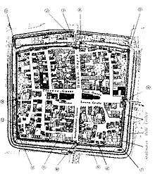
The town charter was granted in May 1273 by Duke Ludwig II. The oldest documented area of Neustadt was the village of Trephenau.[3] This town charter is the oldest in Bavaria. With the town survey and the consequent reinvestment and resettlement by Duke Ludwig II, to secure the Danube Valley Road. The town charter is one of many granted by early Wittelsbach dukes. Neustadt was mentioned in a document of Abbot Conrad of Weltenburg from 1277.
The settlement Wöhr directly opposite Neustadt on the other Danube riverbank is actually older than Neustadt, which is now a district. Wöhr was incorporated in the late Middle Ages as part of the city of Neustadt and residents of Wöhr could be citizens of the city, but lived outside the fortification. Wöhr was also the headquarters of the noble family of the Lords of Wöhr and the ducal Urbar Office "ze Become".
References
- ↑ "Fortschreibung des Bevölkerungsstandes". Bayerisches Landesamt für Statistik und Datenverarbeitung (in German). June 2016.
- ↑ Bayerische Landesbibliothek Online.
- ↑ Georg Köglmeier, Neustadt an der Donau. Eine bayerische Landstadt und ihre Bewohner im Wandel der Jahrhunderte. Band I: Von den Anfängen bis um 1800, Neustadt an der Donau 1994.
External links
| Wikimedia Commons has media related to Neustadt an der Donau. |
- (German) Municipal website
- (German) Official website of Bad Gögging
Towns and municipalities in Kelheim | ||
|---|---|---|