Neißeaue
| Neißeaue | ||
|---|---|---|
|
Easternmost point in Germany | ||
| ||
 Neißeaue | ||
Location of Neißeaue within Görlitz district 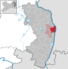
 | ||
| Coordinates: 51°14′50″N 14°58′30″E / 51.24722°N 14.97500°ECoordinates: 51°14′50″N 14°58′30″E / 51.24722°N 14.97500°E | ||
| Country | Germany | |
| State | Saxony | |
| District | Görlitz | |
| Municipal assoc. | Weißer Schöps/Neiße | |
| Government | ||
| • Mayor | Ernst Ewald | |
| Area | ||
| • Total | 47.29 km2 (18.26 sq mi) | |
| Population (2015-12-31)[1] | ||
| • Total | 1,726 | |
| • Density | 36/km2 (95/sq mi) | |
| Time zone | CET/CEST (UTC+1/+2) | |
| Postal codes | 02829 | |
| Dialling codes | 035820 | |
| Vehicle registration | GR | |
| Website | www.neisseaue.de | |


Neißeaue (Upper Sorbian: Nysowa łučina) is a municipality in the district Görlitz, Saxony, Germany. The easternmost point in Germany lies within its municipal limits, including Deschka, roughly 7.5 km north-east of Neißeaue's town center, the easternmost settlement in Germany.
From German unification in 1871 until World War II, the title was held by the village of Gingen, in East Prussia.
References
This article is issued from Wikipedia - version of the 11/27/2016. The text is available under the Creative Commons Attribution/Share Alike but additional terms may apply for the media files.