Needle Peak (Livingston Island)
| Needle Peak | |
|---|---|
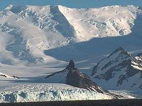 Needle Peak from Bransfield Strait, with Peshev Ridge on the right, and Macy Glacier surmounted by Levski Peak and St. Ivan Rilski Col in the background. | |
| Highest point | |
| Elevation | 370 m (1,210 ft) [1] |
| Coordinates | 62°44′S 60°11′W / 62.733°S 60.183°WCoordinates: 62°44′S 60°11′W / 62.733°S 60.183°W [1] |
| Geography | |
| Location | Livingston Island, Antarctica |
| Climbing | |
| First ascent | unclimbed |
Location of Rozhen Peninsula on Livingston Island in the South Shetland Islands.

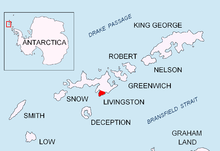
Topographic map of Livingston Island, Greenwich, Robert, Snow and Smith Islands.
Needle Peak is a sharply pointed black peak, 370 m, standing at the west side of Brunow Bay on the south coast of Livingston Island in the South Shetland Islands. Situated in the southeast foothills of Friesland Ridge, Tangra Mountains on Rozhen Peninsula, 1 km south-southeast of Ludogorie Peak, and surmounting Prespa Glacier to the west, Samuel Point to the east by south, and Brunow Bay to the northeast.
The feature was named ‘Barnards Peak’ on James Weddell's chart published in 1825, but the name ‘Needle Peak’ given by Discovery Investigations personnel following a 1935 survey has succeeded it in usage. The name Barnard Point has been approved for the nearby point at the southeast side of False Bay.[1]
Maps
- L.L. Ivanov et al., Antarctica: Livingston Island and Greenwich Island, South Shetland Islands (from English Strait to Morton Strait, with illustrations and ice-cover distribution), 1:100000 scale topographic map, Antarctic Place-names Commission of Bulgaria, Sofia, 2005
- L.L. Ivanov. Antarctica: Livingston Island and Greenwich, Robert, Snow and Smith Islands. Scale 1:120000 topographic map. Troyan: Manfred Wörner Foundation, 2009. ISBN 978-954-92032-6-4
References
- 1 2 3 "Needle Peak". Geographic Names Information System. United States Geological Survey. Retrieved 2009-08-30.
This article is issued from Wikipedia - version of the 11/21/2015. The text is available under the Creative Commons Attribution/Share Alike but additional terms may apply for the media files.