Navrongo
| Navrongo | |
|---|---|
| Town & District Capital | |
 Location of Navrongo. Navrongo is in the north east of North Ghana, beside the Burkina Faso border. | |
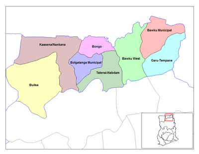
 Navrongo Location of Navrongo in Upper East region | |
| Coordinates: 10°53′5″N 1°5′25″W / 10.88472°N 1.09028°WCoordinates: 10°53′5″N 1°5′25″W / 10.88472°N 1.09028°W | |
| Country | Ghana |
| Region | Upper East Region |
| District | Kassena-Nankana District |
| Population (2012) | |
| • Total | 27,306[1] |
| Time zone | GMT |
| • Summer (DST) | GMT (UTC) |
Navrongo is a town and the capital of Kassena-Nankana District in the Upper East Region of north Ghana. Navrongo is the capital of Kassena-Nankana District – which is within the Upper East Region of north Ghana. Navrongo has a 2012 settlement population of 27,306 people.[1]
Navrongo is an important market town, known for its cathedral and its grotto. Navrongo is located at 10°53′5″N 1°5′25″W / 10.88472°N 1.09028°W. Navrongo's population in 2005 was estimated to be 25,470,[2] and its population in 2012 was estimated to be 27,306.[1] The terrain is flat and the ecology is typical of the Sahel – arid grassland with occasional shrubbery.
The first ever Solar Plant with a capacity of 2 Megawatts in Ghana is located at Navrongo.[3]
History
The town was founded around 1740.[4] During the 19th century, the town became an important staging post on the Sahel caravan route. At the beginning of the 20th century the British established a base at Navrongo.[5]
A Catholic mission was established in 1906 - the White Fathers ("Pères Blancs"), a French group made up of French Canadians. They came to Upper East region from Upper Volta (now Burkina Faso) due to French anti-clerical laws (the Fathers believed they would be expelled from Upper Volta). The British allowed them to set up in Navrongo on condition that the school that they were to establish used English only. Despite a rocky beginning (the Fathers had learnt the wrong local language and only attracted 5 students in the first 18 months), the school eventually became a success – a British official in 1927 said that it was the best school (of only 5) in the north of Ghana.[6]
Climate
| Climate data for Navrongo | |||||||||||||
|---|---|---|---|---|---|---|---|---|---|---|---|---|---|
| Month | Jan | Feb | Mar | Apr | May | Jun | Jul | Aug | Sep | Oct | Nov | Dec | Year |
| Record high °C (°F) | 40.6 (105.1) |
41.7 (107.1) |
42.2 (108) |
42.8 (109) |
42.2 (108) |
38.3 (100.9) |
35.0 (95) |
32.8 (91) |
34.4 (93.9) |
37.8 (100) |
38.3 (100.9) |
38.3 (100.9) |
42.8 (109) |
| Average high °C (°F) | 35.6 (96.1) |
37.2 (99) |
38.9 (102) |
38.3 (100.9) |
36.1 (97) |
32.8 (91) |
30.6 (87.1) |
29.4 (84.9) |
30.6 (87.1) |
33.3 (91.9) |
36.1 (97) |
35.0 (95) |
34.5 (94.1) |
| Daily mean °C (°F) | 27.5 (81.5) |
29.7 (85.5) |
31.7 (89.1) |
32.0 (89.6) |
30.6 (87.1) |
28.1 (82.6) |
26.4 (79.5) |
25.8 (78.4) |
26.1 (79) |
27.5 (81.5) |
28.1 (82.6) |
26.7 (80.1) |
28.4 (83.1) |
| Average low °C (°F) | 19.4 (66.9) |
22.2 (72) |
24.4 (75.9) |
25.6 (78.1) |
25.0 (77) |
23.3 (73.9) |
22.2 (72) |
22.2 (72) |
21.7 (71.1) |
21.7 (71.1) |
20.0 (68) |
18.3 (64.9) |
22.2 (72) |
| Record low °C (°F) | 12.8 (55) |
16.1 (61) |
18.3 (64.9) |
20.0 (68) |
18.9 (66) |
19.4 (66.9) |
19.4 (66.9) |
19.4 (66.9) |
17.8 (64) |
19.4 (66.9) |
16.1 (61) |
13.3 (55.9) |
12.8 (55) |
| Average rainfall mm (inches) | 0.5 (0.02) |
5.6 (0.22) |
15.5 (0.61) |
48.5 (1.909) |
111.5 (4.39) |
144.3 (5.681) |
200.9 (7.909) |
263.4 (10.37) |
228.6 (9) |
67.6 (2.661) |
6.1 (0.24) |
1.3 (0.051) |
1,093.8 (43.063) |
| Source: Sistema de Clasificación Bioclimática Mundial[7] | |||||||||||||
Economy
Subsistence level agriculture is the usual economic occupation of Navrongo, as well as the rearing of goats and cattle.
Navrongo Cathedral
Navrongo Cathedral, as it is now known, was built in 1906 and expanded in 1920. Originally called "Our Lady of Seven Sorrows", the construction was overseen by the White Fathers. The walls are of mud (therefore it is also called "Mud Cathedral"), and wooden beams form the roof. On the inside, the walls are decorated with animal forms, scenes of everyday life, and Christian themes such as the Last Supper and the Bethlehem scene in the entrance area. The site also contains a grotto and accommodation facilities. For copious images and content, see Navrongo Cathedral.
Etymology of name
The word "Navrongo" is an Anglicization of the name navorlngo. This in turn comes from the name navoro,[8] which combines the word naga (meaning foot or leg) with voro (meaning the sound of stepping onto crunchy, dry soil).[9]
See also
References
- 1 2 3 "World Gazetteer online". World-gazetteer.com.
- ↑ "2005 population estimates for cities in Ghana". Retrieved 2007-09-26.
- ↑ VRA completes 1st Solar Plant in Navrongo. ghana.gov.gh.
- ↑ Adewoba. 'Aspects of Wealth and Exchange'.
- ↑ Arhim. 'The Papers of George Ferguson'.
- ↑ Kimble. 'A political history of Ghana'.
- ↑ "Ghana–Navrongo". Centro de Investigaciones Fitosociológicas. Retrieved June 14, 2015.
- ↑ Kasem. verizon.net.
- ↑ St. John-Parsons, Donald. 'Legends of Northern Ghana'.
External links
| Wikimedia Commons has media related to Navrongo. |
- Navrongo Health Research Centre — a Ghana Health Service research centre based in Navrongo.
- MSN Map
| Municipal |
|  |
|---|---|---|
| District |
| |