Navarre, Florida
| Navarre, Florida | |
|---|---|
| Unincorporated Community | |
Unincorporated Community of Navarre
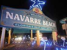
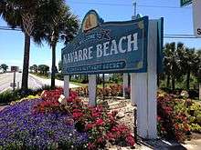
 Navarre Beach skyline  Navarre Beach | |
| Nickname(s): Florida's Best Kept Secret, Florida's Playground, Florida's Crossroads | |
| Country | United States |
| State | Florida |
| County | Santa Rosa |
| First Explored | 1693 |
| Settled | 1850 |
| Founded (as Navarre) | 1925 |
| Founded by | Guy Wyman |
| Named for | Province in Spain, Navarre |
| Government | |
| • Body | Santa Rosa County |
| Area | |
| • Unincorporated Community | 89.43 sq mi (231.6 km2) |
| Elevation | 10 ft (3 m) |
| Lowest elevation | 0 ft (0 m) |
| Population (2014) | |
| • Unincorporated Community | 42,200 |
| • Metro | 461,227 (Pensacola metropolitan area) |
| Time zone | CST (UTC+6:00) |
| ZIP code | 32566 |
| Area code(s) | 850 |
| Website | http://www.floridasplayground.com/navarre-beach/ |
| Historical population | |||
|---|---|---|---|
| Census | Pop. | %± | |
| 1990 | 8,673 | — | |
| 2000 | 19,255 | 122.0% | |
| 2010 | 31,378 | 63.0% | |
| Est. 2014 | 42,200 | 34.5% | |
Navarre is an unincorporated community in Santa Rosa County in the northwest Florida Panhandle. It is a bedroom community for mostly U.S. Military personnel, Federal Civil Servants, local population, retirees and defense contractors. Due to its proximity to Navarre Beach and its four miles of beach front on the Gulf of Mexico as well as the Gulf Islands National Seashore, it has a small, but growing community of nature enthusiasts and tourists.
Navarre is about 25 miles east of Pensacola and about 15 miles west of Fort Walton Beach. The community is roughly centered on the junction of U.S. Route 98 and State Road 87.[1] It is part of the Pensacola–Ferry Pass–Brent Metropolitan Statistical Area and is known for the untarnished natural beauty, swimming in the emerald colored water, having a picnic on the beach or in the county park which is located directly on the Gulf of Mexico. Residents and visitors alike enjoy riding or jogging on the several scenic bike paths.
History
The Pez-Sigüenza Expedition of 1693
In 1693, Spanish explorers, Carlos de Sigüenza y Góngora and Admiral Andrés de Pez y Malzarraga, set sail from Veracruz, Mexico. A skilled cartographer (as well as a scientist, mathematician and theologian), Sigüenza was responsible for scouting and mapping possible sites of Spanish colonization in Northwest Florida during the expedition. While traveling in the area of East Bay in April 1693, the Spanish discovered what is today called the East Bay River. In honor of Captain Jordan de Reina, an officer who had taken part in the Barroto-Romero voyage of 1686 as well as Sigüenza's in 1693, the Spanish dubbed the waters on which they traveled, "The River Jordan". On April 11, 1693, while sailing up East Bay River, sailors aboard the Spanish ships noticed a group of Native Americans observing them from a camp near the shore. In order to greet the natives, a landing party was sent out. By the time the Spanish reached the shore however, the Native Americans were gone. At the natives' quickly abandoned camp, the Spanish discovered half-cooked pieces of buffalo meat sitting over a fire, along with a fierce dog guarding the site. Due to the great number of oak trees in that place, the campsite was called “El Robledal”, meaning "The Oakgrove" in Spanish. After erecting a wooden cross and leaving gifts for the natives, the Spaniards continued their exploration upriver. Upon later return to El Robledal, the explorers noticed that their gifts had been taken. In return, the natives had also constructed a wooden cross and left a buffalo hide as a peace offering. The earliest-known map of Robledal is dates from 1693, the same year as the Pez-Sigüenza Expedition. Three years later, in a 1698 map by Don Andrés de Arriola y Guzmán (the first governor of a settlement in the Pensacola area after the Tristán de Luna y Arellano colony was abandoned), Robledal is again noted. [2]
Town of Eagan
About 41 years before Guy H. Wyman platted Navarre, a small settlement named Eagan arose in 1884. The settlement, composed of 40 families, was located off the Santa Rosa Sound and encompassed a portion of present-day Navarre. The settlement, which formerly existed as a post office location, was named after its first postmaster, John Eagan Esq., a famous Pensacola lawyer and politician. Following the post office’s discontinuation Sep. 11, 1884, families continued to live in the area, and the town continued to appear on area maps even into the 1890s. While what became of the town and the people who lived there at that time is unknown, the discovery of the town's existence in 1915 definitively established settlement of the Navarre-area in South Santa Rosa County as being prior to the 20th century. The land upon which Eagan existed would, in fact, later become what is now known as Navarre.[3]
Guy Wyman and town development
The founder of Navarre was Guy Wyman, a colonel in the United States Army. During World War I, he met a French nurse named Noel. At the time, immigration policies would not allow him to bring her to the United States as a fiancée or even as a wife, but he could bring her back as his legal child. Col. Wyman therefore adopted her, and brought her back to the Florida panhandle, where he purchased a large amount of land. Noel named their holdings Navarre, after the province in Spain, near France.[1][4] Wyman platted the town in 1925,[1] but made no steps towards development. However, during the Great Depression, the Wymans could not pay the taxes on it, and were forced to begin selling it off. Part of that property is where the Navarre Park is today. While protecting and enhancing the natural beauty of the area; several steps have been taken to develop luxury accommodations, water activities, boutique shopping, scenic trails, top rated schools and nature/educational opportunities.
Helicopter crash
On March 10, 2015, a UH-60 from Eglin Air Force Base crashed in the Santa Rosa Sound off the coast of the community of Navarre. All eleven on board were believed killed.[5] A memorial was recently built in Navarre Park in memory of the crash and to honor the large military and veteran population of the community.[6]
Geography
Navarre is located at 30°24′04″N 86°51′47″W / 30.401°N 86.863°WCoordinates: 30°24′04″N 86°51′47″W / 30.401°N 86.863°W. It is located within a portion of the Florida Panhandle observing the Central Time Zone. Elevation is 10 feet.[7]
Navarre is on roughly 12 miles of shoreline.[8]
The community of Navarre is located on the Gulf Coastal Plain and is built on mostly sandy soil. Navarre is located on the Fairpoint Peninsula. It is bunded geographically in the north by the East River and on the south by the Santa Rosa Sound.[1]
Demographics
According to different estimates the population ranges from 40,000 to 42,200 residents living in the unincorporated area of Navarre. The below racial characteristics of the community are from 2013 estimates.
If the town of Navarre was to be incorporated it would be the largest city between Pensacola and Tallahassee (based on population).
- White 93.5%
- Black 3.9%
- Hispanic 1.7%
- Native American and Alaska Native 0.7%
- Asian 1.1%
- Native Hawaiian and other Pacific Islander 0.5%
- Other 2.0%
- Multiracial 0.2%
Attractions
Navarre is centered near the junction of U.S. Highway 98, the primary east-west route between Pensacola and the Fort Walton Beach area, and State Road 87. It is located near several large military facilities: Naval Air Station Pensacola to the west; Hurlburt Field and Eglin Air Force Base to the east; and Naval Air Station Whiting Field to the North.
Tourism has increased in the Navarre area since 2010, being declared "Florida's Best Kept Secret" by the local hospitality business. Navarre has a park on the mainland next to Navarre Beach bridge and the Intracoastal Waterway that contains a Visitor Information Center; water splash pad, duck pond, butterfly house, playground, gazebos; pier and small beach area. Boating, Surfing, jet skiing, paddle boarding, fishing, bird watching, exploring scenic trails and walking/jogging are popular among the residents and visitors.
In 2010 the Navarre Beach fishing pier was rebuilt after repeated damage from hurricanes. At 1,545-feet, it is currently the longest fishing pier on the Gulf of Mexico and in the state of Florida.[9]
Hurricanes
As a low-elevation community near the Gulf of Mexico, Navarre is often threatened by hurricanes. Significant damage was incurred as a result of Hurricanes Erin, Opal, Ivan and Dennis. Many homes and businesses immediately along Santa Rosa Sound (generally south of U.S. Highway 98) suffered storm surge as a result of those storms. Recoveries have been rendered by the area with the population quickly flourishing. This area of Florida is consistently listed as one of the worst places for hurricanes.[10]
Education
Education in Navarre is administrated by the Santa Rosa County District School system headquartered in Milton, Florida. The schools that serve the Navarre community are:
- Navarre High School (Grades 9–12[11])
- Holley Navarre Middle School (Grades 6–8)
- Holley Navarre Intermediate School (Grades 3–5)
- Holley Navarre Primary School (Grades K–2)
- Woodlawn Beach Middle School (Grades 6–8)
- West Navarre Primary School (Grades K–2)
- West Navarre Intermediate School (Grades 3–5)
Popular Culture
Jaws 2

A large portion of the scenes in Jaws 2 were filmed off the coast of Navarre and Navarre Beach circa 1977.[12]
See also
References
- 1 2 3 4 "Navarre Town Center Plan" (PDF). Santa Rosa County Board of Commissioners. Archived from the original (PDF) on October 30, 2007. Retrieved 2007-12-07.
- ↑ "Navarre's earliest recorded heritage began with Spanish explorers in 1693". www.navarrepress.com. Retrieved 2016-06-13.
- ↑ "When Navarre was Eagan". www.navarrepress.com. Retrieved 2015-12-01.
- ↑ "Discover Navarre Beach Florida". Archived from the original on April 10, 2006.
- ↑ "Reports: Cause of Black Hawk crash released". Pensacola News Journal. Retrieved 2016-01-27.
- ↑ "Navarre Black Hawk Memorial taking shape". Pensacola News Journal. Retrieved 2016-01-27.
- ↑ "USGS Geographic Names Information System". US Geological Survey. Retrieved 2010-02-02.
- ↑ "Navarre". www.visitflorida.com. Retrieved 2015-11-27.
- ↑ "Welcome to Navarre Beach". www.santarosa.fl.gov. Retrieved 2015-11-27.
- ↑ "The Worst Places for Hurricanes". www.bestplaces.net. Retrieved 2015-11-27.
- ↑ "Home of the Navarre High School Raiders". www.santarosa.k12.fl.us. Retrieved 2015-11-27.
- ↑ Szwarc, Jeannot (1978-06-16), Jaws 2, retrieved 2016-02-23
External links
- Greatest Navarre Area Chamber of Commerce
- Holley-Navarre Historical Society
- Navarre Beach Area Official Visitor Information: Florida Beaches to Rivers
- Holley-Navarre Fire District
Municipalities and communities of Santa Rosa County, Florida, United States | ||
|---|---|---|
| Cities | 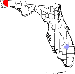 | |
| Town | ||
| CDPs |
| |
| Unincorporated communities |
| |