National System of Protected Areas in Uruguay
The National System of Protected Natural Areas of Uruguay (Spanish: Sistema nacional de áreas naturales protegidas de Uruguay, commonly abbreviated as SNAP) is an instrument of policy implementation and national environmental action plans for Uruguay.
Its creation was established by Law 17,234 of February 22, 2000, which was regulated by Executive Decree No. 52/005 of February 16, 2005. This law aims to "harmonize the criteria for planning and managing protected areas under certain categories, with a single regulation that sets the guidelines system" (Art. 1).[1][2]
Categories
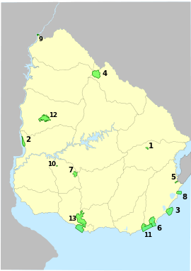
Uruguay Protected Areas included in SNAP until 2013:
1-Quebrada de los Cuervos; 2-Esteros de Fárrapos; 3-Cabo Polonio; 4-Valle del Lunarejo; 5-San Miguel; 6-Laguna de Rocha; 7-Chamangá; 8-Cerro Verde e Islas de la Coronilla; 9-Rincón de Franquía; 10-Palace Cave; 11-Laguna Garzón; 12-Montes del Queguay; 13-Humedales del Santa Lucía.
1-Quebrada de los Cuervos; 2-Esteros de Fárrapos; 3-Cabo Polonio; 4-Valle del Lunarejo; 5-San Miguel; 6-Laguna de Rocha; 7-Chamangá; 8-Cerro Verde e Islas de la Coronilla; 9-Rincón de Franquía; 10-Palace Cave; 11-Laguna Garzón; 12-Montes del Queguay; 13-Humedales del Santa Lucía.
According to Law 17234, four categories of definition and management of the protected natural areas were established (Art.3°):[1]
- National park: areas where there are one or more ecosystems that are not significantly altered by human explotation and occupation, plant and animal species; they are geomorphological sites and habitats that have special scientific, educational and recreational interest, or include natural landscapes which are considered of exceptional beauty.
- Natural monument: areas containing one or more specific natural elements of remarkable national importance, such as a geological formation, a unique natural site, species, habitats or plants that may be endangered. Areas where human intervention, if realized, is small in impact and is under strict control.
- Protected landscape
- Protection sites
References
- 1 2 Legislative Branch (February 22, 2000). "Law 17,234" (in Spanish). Retrieved February 21, 2014.
- ↑ Executive Branch (February 16, 2005). "Decreto 52/005 Sistema Nacional de Áreas Portegidas" (in Spanish). Retrieved February 21, 2014.
This article is issued from Wikipedia - version of the 9/5/2016. The text is available under the Creative Commons Attribution/Share Alike but additional terms may apply for the media files.