| [3] |
Name on the Register |
Image |
Date listed[4] |
Location |
City or town |
Description |
|---|
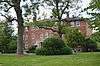
| 1 |
Airy Mount |
Upload image |
000000001978-11-15-0000November 15, 1978
(#78001417) |
Southwest of Versailles off U.S. Route 62
38°01′38″N 84°46′28″W / 38.027222°N 84.774444°W / 38.027222; -84.774444 (Airy Mount) |
Versailles |
|
| 2 |
Alexander Plantation House |
Upload image |
000000001983-06-23-0000June 23, 1983
(#83002891) |
Off Old Frankford Pike
38°08′45″N 84°44′29″W / 38.145833°N 84.741389°W / 38.145833; -84.741389 (Alexander Plantation House) |
Midway |
|
| 3 |
John Allen House |
Upload image |
000000001983-06-23-0000June 23, 1983
(#83002892) |
Off Kentucky Route 169
37°58′40″N 84°41′00″W / 37.977778°N 84.683333°W / 37.977778; -84.683333 (John Allen House) |
Keene |
|
| 4 |
Archeological Site 15Wd61 |
Upload image |
000000001982-06-02-0000June 2, 1982
(#82004853) |
Address Restricted
|
Nonesuch |
|
| 5 |
Arnold-Wooldridge House |
Upload image |
000000001979-05-29-0000May 29, 1979
(#79001048) |
South of Versailles
38°00′21″N 84°45′52″W / 38.005833°N 84.764444°W / 38.005833; -84.764444 (Arnold-Wooldridge House) |
Versailles |
|
| 6 |
Ayres House |
Upload image |
000000001994-01-27-0000January 27, 1994
(#93001522) |
Southern side of U.S. Route 421, less than 0.3 miles east of Drucker's Rd.
38°10′32″N 84°46′26″W / 38.175556°N 84.773889°W / 38.175556; -84.773889 (Ayres House) |
Midway |
|
| 7 |
Big Sink Rural Historic District |
Upload image |
000000001994-01-27-0000January 27, 1994
(#93001523) |
West of Midway off Interstate 64
38°07′17″N 84°43′17″W / 38.121389°N 84.721389°W / 38.121389; -84.721389 (Big Sink Rural Historic District) |
Versailles |
|
| 8 |
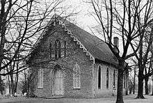
Big Spring Church |
|
000000001975-05-06-0000May 6, 1975
(#75000842) |
121 Rose Hill St.
38°03′07″N 84°43′54″W / 38.051806°N 84.731667°W / 38.051806; -84.731667 (Big Spring Church) |
Versailles |
|
| 9 |
Charles Black Farm |
Upload image |
000000001989-02-10-0000February 10, 1989
(#88003347) |
Faywood Rd.
38°06′18″N 84°38′34″W / 38.105°N 84.642778°W / 38.105; -84.642778 (Charles Black Farm) |
Versailles |
|
| 10 |
Edward M. Blackburn House |
Upload image |
000000001985-12-05-0000December 5, 1985
(#85003073) |
Spring Station Rd.
38°09′30″N 84°44′02″W / 38.158333°N 84.733889°W / 38.158333; -84.733889 (Edward M. Blackburn House) |
Midway |
|
| 11 |
Lucas Broadhead House |
Upload image |
000000001994-01-27-0000January 27, 1994
(#93001524) |
Southwestern corner of the junction of Midway Pike and Aiken Rd.
38°05′41″N 84°43′20″W / 38.094722°N 84.722222°W / 38.094722; -84.722222 (Lucas Broadhead House) |
Versailles |
|
| 12 |
Buck Pond |
Upload image |
000000001989-02-10-0000February 10, 1989
(#88003344) |
Paynes Mill Rd.
38°04′00″N 84°41′13″W / 38.066667°N 84.686944°W / 38.066667; -84.686944 (Buck Pond) |
Versailles |
|
| 13 |
Bullock Site |
Upload image |
000000002005-03-15-0000March 15, 2005
(#05000145) |
Address Restricted
|
Versailles |
|
| 14 |
Marquis Calmes Tomb |
Upload image |
000000001989-02-10-0000February 10, 1989
(#88003346) |
Paynes Mill Rd.
38°03′32″N 84°40′28″W / 38.058889°N 84.674444°W / 38.058889; -84.674444 (Marquis Calmes Tomb) |
Versailles |
|
| 15 |
Carter House |
|
000000001975-05-02-0000May 2, 1975
(#75000843) |
110 Morgan St.
38°03′05″N 84°43′48″W / 38.051389°N 84.730000°W / 38.051389; -84.730000 (Carter House) |
Versailles |
|
| 16 |
Cleveland House |
|
000000002007-04-10-0000April 10, 2007
(#07000287) |
140 Park St.
38°03′16″N 84°43′56″W / 38.054444°N 84.732222°W / 38.054444; -84.732222 (Cleveland House) |
Versailles |
|
| 17 |
Clifton Country Club |
Upload image |
000000001995-11-07-0000November 7, 1995
(#95001271) |
1190 Buck Run Rd.
38°04′19″N 84°50′17″W / 38.071944°N 84.838056°W / 38.071944; -84.838056 (Clifton Country Club) |
Versailles |
|
| 18 |
Clifton-McCraken Rural Historic District |
Upload image |
000000001999-01-25-0000January 25, 1999
(#98000326) |
Roughly along Clifton and McCraken Pikes, and Steele Rd.
38°04′26″N 84°47′54″W / 38.073889°N 84.798333°W / 38.073889; -84.798333 (Clifton-McCraken Rural Historic District) |
Versailles |
|
| 19 |
Richard Cole Homestead |
Upload image |
000000001994-01-27-0000January 27, 1994
(#93001525) |
Southern side of Leestown Rd., northwest of Midway
38°09′58″N 84°42′32″W / 38.166111°N 84.708889°W / 38.166111; -84.708889 (Richard Cole Homestead) |
Midway |
|
| 20 |
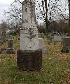
Confederate Monument in Versailles |
|
000000001997-07-17-0000July 17, 1997
(#97000662) |
City Cemetery, southeast of the junction of Clifton Rd. and Kentucky Route 33
38°02′57″N 84°43′44″W / 38.049167°N 84.728889°W / 38.049167; -84.728889 (Confederate Monument in Versailles) |
Versailles |
|
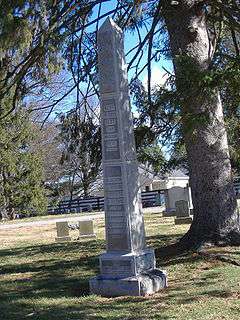
| 21 |
Cooper House |
Upload image |
000000001994-01-27-0000January 27, 1994
(#93001526) |
Northern side of Leestown Rd., 0.9 miles east of the Midway exit from Interstate 64
38°09′05″N 84°39′47″W / 38.151389°N 84.663056°W / 38.151389; -84.663056 (Cooper House) |
Midway |
|
| 22 |
Downtown Versailles Historic District |
|
000000001975-09-02-0000September 2, 1975
(#75000844) |
Both sides of Main St. between Rose Hill Ave. and Green St.
38°03′08″N 84°43′50″W / 38.052222°N 84.730556°W / 38.052222; -84.730556 (Downtown Versailles Historic District) |
Versailles |
|
| 23 |
Joel DuPuy House |
|
000000001983-06-23-0000June 23, 1983
(#83002893) |
Griers Creek Rd.
38°00′52″N 84°47′49″W / 38.014444°N 84.796944°W / 38.014444; -84.796944 (Joel DuPuy House) |
Tyrone |
|
| 24 |
Edgewood |
Upload image |
000000001976-05-28-0000May 28, 1976
(#76000960) |
1 mile east of Versailles on U.S. Route 60
38°03′11″N 84°42′15″W / 38.053056°N 84.704167°W / 38.053056; -84.704167 (Edgewood) |
Versailles |
|
| 25 |
Thomas Edwards House and Quarters |
Upload image |
000000001983-06-23-0000June 23, 1983
(#83002894) |
Kentucky Route 1659
38°05′02″N 84°46′44″W / 38.083889°N 84.778889°W / 38.083889; -84.778889 (Thomas Edwards House and Quarters) |
Tyrone |
|
| 26 |
Elkwood |
Upload image |
000000001994-01-27-0000January 27, 1994
(#93001527) |
158 Leestown Pike, W.
38°09′44″N 84°40′56″W / 38.162222°N 84.682222°W / 38.162222; -84.682222 (Elkwood) |
Midway |
|
| 27 |
William Garrett House |
Upload image |
000000001983-06-23-0000June 23, 1983
(#83002895) |
Off Kentucky Route 169
37°59′37″N 84°40′51″W / 37.993611°N 84.680833°W / 37.993611; -84.680833 (William Garrett House) |
Keene |
|
| 28 |
John Graham House |
Upload image |
000000001978-11-14-0000November 14, 1978
(#78001416) |
Southeast of Midway on Weisenberger Mill Rd.
38°08′20″N 84°40′26″W / 38.138889°N 84.673889°W / 38.138889; -84.673889 (John Graham House) |
Midway |
|
| 29 |
Guyn's Mill Historic District |
|
000000001983-08-29-0000August 29, 1983
(#83002897) |
Mundy's Landing and Pauls Mill Rds.
37°54′02″N 84°42′29″W / 37.900556°N 84.708056°W / 37.900556; -84.708056 (Guyn's Mill Historic District) |
Troy |
|
| 30 |
Robert Guyn, Jr. House |
Upload image |
000000001983-08-25-0000August 25, 1983
(#83002896) |
South of Troy on Kentucky Route 33
37°53′51″N 84°42′20″W / 37.8975°N 84.705556°W / 37.8975; -84.705556 (Robert Guyn, Jr. House) |
Troy |
|
| 31 |
Ezra Hammon House |
Upload image |
000000001983-08-22-0000August 22, 1983
(#83002898) |
Off Kentucky Route 33
37°56′18″N 84°42′02″W / 37.938333°N 84.700556°W / 37.938333; -84.700556 (Ezra Hammon House) |
Keene |
|
| 32 |
A.T. Harris House |
Upload image |
000000001989-02-10-0000February 10, 1989
(#88003345) |
Big Sink Pike
38°06′22″N 84°40′19″W / 38.106111°N 84.671944°W / 38.106111; -84.671944 (A.T. Harris House) |
Versailles |
|
| 33 |
Hogan Quarters |
Upload image |
000000001983-08-22-0000August 22, 1983
(#83002899) |
Off Kentucky Route 33
38°01′18″N 84°43′18″W / 38.021667°N 84.721667°W / 38.021667; -84.721667 (Hogan Quarters) |
Versailles |
|
| 34 |
Humphries Estate Quarters |
Upload image |
000000001983-06-23-0000June 23, 1983
(#83002900) |
Kentucky Route 1967
38°00′07″N 84°40′06″W / 38.001944°N 84.668333°W / 38.001944; -84.668333 (Humphries Estate Quarters) |
Versailles |
|
| 35 |
Dr. William Jennings House |
Upload image |
000000001983-01-12-0000January 12, 1983
(#83002901) |
South of Pinckard on Kentucky Route 169
37°58′24″N 84°40′49″W / 37.973333°N 84.680278°W / 37.973333; -84.680278 (Dr. William Jennings House) |
Pinckard |
|
| 36 |
Capt. Jack Jouett House |
Upload image |
000000001972-06-13-0000June 13, 1972
(#72000548) |
5 miles southwest of Versailles off Kentucky Route 1964
37°58′59″N 84°46′31″W / 37.983056°N 84.775278°W / 37.983056; -84.775278 (Capt. Jack Jouett House) |
Versailles |
|
| 37 |
Labrot & Graham Distillery |
Upload image |
000000001995-11-07-0000November 7, 1995
(#95001272) |
7855 McCracken Pike
38°06′46″N 84°48′43″W / 38.112778°N 84.811944°W / 38.112778; -84.811944 (Labrot & Graham Distillery) |
Frankfort |
|
| 38 |
Leavy Tobacco Barn |
Upload image |
000000001994-01-27-0000January 27, 1994
(#93001528) |
Eastern side of Georgetown Rd., 0.8 miles north of the Midway exit from Interstate 64
38°10′04″N 84°39′29″W / 38.167778°N 84.658056°W / 38.167778; -84.658056 (Leavy Tobacco Barn) |
Midway |
|
| 39 |
Lexington Extension of the Louisville Southern Railroad |
|
000000002004-08-04-0000August 4, 2004
(#04000789) |
Eastern Lawrenceburg to Milner
38°01′56″N 84°49′09″W / 38.032222°N 84.819167°W / 38.032222; -84.819167 (Lexington Extension of the Louisville Southern Railroad) |
Lawrenceburg |
Extends into Anderson County
|
| 40 |
Thomas Lyne House |
Upload image |
000000001980-11-28-0000November 28, 1980
(#80001691) |
South of Versailles on Smith Lane
37°57′28″N 84°41′06″W / 37.957778°N 84.685°W / 37.957778; -84.685 (Thomas Lyne House) |
Versailles |
|
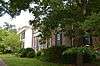
| 41 |
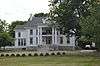
Margaret Hall |
|
000000001987-08-03-0000August 3, 1987
(#87001304) |
117 Elm St.
38°03′26″N 84°43′54″W / 38.057222°N 84.731667°W / 38.057222; -84.731667 (Margaret Hall) |
Versailles |
|
| 42 |
Martyrs Monument in Midway |
|
000000001997-07-17-0000July 17, 1997
(#97000663) |
City Cemetery, southwest of the junction of the L&N railroad tracks and U.S. Route 62
38°08′53″N 84°41′40″W / 38.148056°N 84.694444°W / 38.148056; -84.694444 (Martyrs Monument in Midway) |
Midway |
|
| 43 |
McCrackin Distillery and Mill |
Upload image |
000000001983-06-23-0000June 23, 1983
(#83002903) |
Kentucky Route 1659
38°05′31″N 84°47′17″W / 38.091944°N 84.788056°W / 38.091944; -84.788056 (McCrackin Distillery and Mill) |
Tyrone |
|
| 44 |
Cyrus McCrackin House and Quarters |
Upload image |
000000001983-08-22-0000August 22, 1983
(#83002902) |
Off Steele Rd.
38°06′22″N 84°46′52″W / 38.106111°N 84.781111°W / 38.106111; -84.781111 (Cyrus McCrackin House and Quarters) |
Tyrone |
|
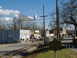
| 45 |
Midway Historic District |
|
000000001978-11-17-0000November 17, 1978
(#78001415) |
U.S. Route 62
38°08′48″N 84°41′14″W / 38.146667°N 84.687222°W / 38.146667; -84.687222 (Midway Historic District) |
Midway |
|
| 46 |
Miller's House at Mortonsville Mill |
Upload image |
000000001983-06-23-0000June 23, 1983
(#83002904) |
Kentucky Route 1965
37°58′19″N 84°45′25″W / 37.971944°N 84.756944°W / 37.971944; -84.756944 (Miller's House at Mortonsville Mill) |
Salvisa |
|
| 47 |
George F. Moore Place |
Upload image |
000000001983-06-23-0000June 23, 1983
(#83002905) |
Off U.S. Route 62
38°06′04″N 84°41′34″W / 38.101111°N 84.692778°W / 38.101111; -84.692778 (George F. Moore Place) |
Versailles |
|
| 48 |
Morgan Street Historic District |
|
000000001980-05-08-0000May 8, 1980
(#80001692) |
Morgan St.
38°03′06″N 84°43′37″W / 38.051667°N 84.726944°W / 38.051667; -84.726944 (Morgan Street Historic District) |
Versailles |
|
| 49 |
Moss Side |
Upload image |
000000001979-01-08-0000January 8, 1979
(#79001049) |
Southwest of Versailles on McCowans Ferry Pike
38°01′10″N 84°46′14″W / 38.019444°N 84.770556°W / 38.019444; -84.770556 (Moss Side) |
Versailles |
|
| 50 |
Andrew Muldrow Quarters |
Upload image |
000000001983-06-23-0000June 23, 1983
(#83002907) |
Griers Creek Rd.
38°01′06″N 84°49′11″W / 38.018333°N 84.819722°W / 38.018333; -84.819722 (Andrew Muldrow Quarters) |
Tyrone |
|
| 51 |
Munday's Landing |
Upload image |
000000001975-09-05-0000September 5, 1975
(#75000845) |
Munday's Landing Rd., south of Versailles on the Kentucky River
37°51′13″N 84°46′16″W / 37.853611°N 84.771111°W / 37.853611; -84.771111 (Munday's Landing) |
Versailles |
|
| 52 |
Claiborne W. Nuckols Farmstead |
Upload image |
000000001994-01-27-0000January 27, 1994
(#93001529) |
Northern side of U.S. Route 60, 1½ miles north of its junction with Midway Pike
38°05′59″N 84°44′45″W / 38.099722°N 84.745833°W / 38.099722; -84.745833 (Claiborne W. Nuckols Farmstead) |
Versailles |
|
| 53 |
Nugent's Crossroad Historic District |
Upload image |
000000001994-01-27-0000January 27, 1994
(#93001530) |
Junction of Midway and Old Frankfort Pikes
38°07′25″N 84°41′57″W / 38.123611°N 84.699167°W / 38.123611; -84.699167 (Nugent's Crossroad Historic District) |
Midway |
|
| 54 |
Offutt-Cole Tavern |
|
000000001977-11-23-0000November 23, 1977
(#77000664) |
North of Versailles on U.S. Route 62
38°07′24″N 84°42′00″W / 38.123333°N 84.7°W / 38.123333; -84.7 (Offutt-Cole Tavern) |
Versailles |
|
| 55 |
Paul Family Complex |
Upload image |
000000001980-09-23-0000September 23, 1980
(#80001690) |
West of Troy on Paul's Mill Rd.
37°54′18″N 84°42′42″W / 37.905°N 84.711667°W / 37.905; -84.711667 (Paul Family Complex) |
Troy |
|
| 56 |
Lewis Payne House |
Upload image |
000000001982-04-29-0000April 29, 1982
(#82002750) |
Lansing Lane
38°07′29″N 84°39′56″W / 38.124722°N 84.665556°W / 38.124722; -84.665556 (Lewis Payne House) |
Midway |
|
| 57 |
Pinkerton Hall |
Upload image |
000000001974-11-20-0000November 20, 1974
(#74000919) |
650 East St.
38°08′46″N 84°40′44″W / 38.146111°N 84.678889°W / 38.146111; -84.678889 (Pinkerton Hall) |
Midway |
|
| 58 |
Pisgah Presbyterian Church |
|
000000001983-08-22-0000August 22, 1983
(#83002906) |
Off U.S. Route 60
38°03′14″N 84°39′17″W / 38.053889°N 84.654722°W / 38.053889; -84.654722 (Pisgah Presbyterian Church) |
Versailles |
|
| 59 |
Pisgah Rural Historic District |
Upload image |
000000001989-02-10-0000February 10, 1989
(#88003348) |
Area northeast of Versailles roughly bounded by S. Elkhorn Creek, U.S. Route 60, and Big Sink Rd.
38°05′08″N 84°39′40″W / 38.085556°N 84.661111°W / 38.085556; -84.661111 (Pisgah Rural Historic District) |
Versailles |
|
| 60 |
Pleasant Lawn |
Upload image |
000000001978-11-15-0000November 15, 1978
(#78001418) |
North of Versailles off U.S. Route 62 at Bonita
38°05′10″N 84°42′29″W / 38.086111°N 84.708056°W / 38.086111; -84.708056 (Pleasant Lawn) |
Versailles |
|
| 61 |
Redd Road Rural Historic District |
Upload image |
000000001991-02-28-0000February 28, 1991
(#91000153) |
Area largely south and east of the junction of Redd and Frankfort Roads
38°05′30″N 84°37′34″W / 38.091667°N 84.626111°W / 38.091667; -84.626111 (Redd Road Rural Historic District) |
Lexington |
Extends into Fayette County
|
| 62 |
Robertson Place |
Upload image |
000000001983-06-23-0000June 23, 1983
(#83002908) |
Clifton and Steele Rds.
38°04′38″N 84°48′30″W / 38.077222°N 84.808333°W / 38.077222; -84.808333 (Robertson Place) |
Tyrone |
|
| 63 |
Rose Hill Historic District |
|
000000001982-12-17-0000December 17, 1982
(#82001578) |
Rose Hill Ave.
38°03′06″N 84°44′06″W / 38.051667°N 84.735°W / 38.051667; -84.735 (Rose Hill Historic District) |
Versailles |
|
| 64 |
Scearce House |
Upload image |
000000001987-04-09-0000April 9, 1987
(#87000602) |
McCracken Pike
38°05′35″N 84°46′30″W / 38.093056°N 84.775°W / 38.093056; -84.775 (Scearce House) |
Versailles |
|
| 65 |
Shipp House |
Upload image |
000000001983-06-30-0000June 30, 1983
(#83002909) |
Address Restricted
|
Midway |
|
| 66 |
South Main Street Historic District |
|
000000001987-07-02-0000July 2, 1987
(#87001106) |
298-321 S. Main St.
38°02′50″N 84°43′47″W / 38.047222°N 84.729722°W / 38.047222; -84.729722 (South Main Street Historic District) |
Versailles |
|
| 67 |
Stone House at Fisher's Mill |
Upload image |
000000001983-06-23-0000June 23, 1983
(#83002912) |
Off U.S. Route 421
38°10′21″N 84°42′16″W / 38.1725°N 84.704444°W / 38.1725; -84.704444 (Stone House at Fisher's Mill) |
Midway |
|
| 68 |
Stone House on Beale's Run |
Upload image |
000000001983-06-23-0000June 23, 1983
(#83002910) |
Off Kentucky Route 1685
38°11′02″N 84°44′32″W / 38.183889°N 84.742222°W / 38.183889; -84.742222 (Stone House on Beale's Run) |
Midway |
|
| 69 |
Stone House on Clifton Pike |
Upload image |
000000001983-06-23-0000June 23, 1983
(#83002911) |
Kentucky Route 1964
38°04′11″N 84°47′09″W / 38.069722°N 84.785833°W / 38.069722; -84.785833 (Stone House on Clifton Pike) |
Tyrone |
|
| 70 |
Stone House on Steele's Grant |
Upload image |
000000001983-06-23-0000June 23, 1983
(#83002575) |
Off Kentucky Route 1964
38°04′18″N 84°48′58″W / 38.071667°N 84.816111°W / 38.071667; -84.816111 (Stone House on Steele's Grant) |
Tyrone |
|
| 71 |
Stone House on Tanner's Creek |
Upload image |
000000001983-06-23-0000June 23, 1983
(#83002913) |
Carpenter Pike
37°58′49″N 84°45′29″W / 37.980278°N 84.758056°W / 37.980278; -84.758056 (Stone House on Tanner's Creek) |
Salvisa |
|
| 72 |
E.W. Taylor House |
Upload image |
000000001994-01-27-0000January 27, 1994
(#93001531) |
Eastern side of Midway Pike, about ½ mile north of its junction with Old Frankfort Pike
38°07′37″N 84°41′03″W / 38.126944°N 84.684167°W / 38.126944; -84.684167 (E.W. Taylor House) |
Midway |
|
| 73 |
Solomon Thomas House |
Upload image |
000000001983-06-23-0000June 23, 1983
(#83002914) |
Craigs Creek Rd.
37°59′21″N 84°48′06″W / 37.989167°N 84.801667°W / 37.989167; -84.801667 (Solomon Thomas House) |
Salvisa |
|
| 74 |
W.B. Spring House |
Upload image |
000000001983-06-23-0000June 23, 1983
(#83002915) |
Off U.S. Route 62
38°06′43″N 84°41′40″W / 38.111944°N 84.694444°W / 38.111944; -84.694444 (W.B. Spring House) |
Versailles |
|
| 75 |
Versailles Elementary School |
Upload image |
000000002015-07-10-0000July 10, 2015
(#15000459) |
299 S. Main St.
38°02′51″N 84°43′48″W / 38.0474°N 84.7299°W / 38.0474; -84.7299 (Versailles Elementary School) |
Versailles |
Now the Safe Harbor Academy
|
| 76 |
Wallace Station Historic District |
Upload image |
000000001994-01-27-0000January 27, 1994
(#93001534) |
Wallace Station, Old Frankfort Pike
38°07′16″N 84°41′39″W / 38.121111°N 84.694167°W / 38.121111; -84.694167 (Wallace Station Historic District) |
Midway |
|
| 77 |
Samuel Wallace House |
Upload image |
000000001994-01-27-0000January 27, 1994
(#93001532) |
Northern side of Old Frankfort Pike, east of Wallace
38°07′10″N 84°41′16″W / 38.119444°N 84.687778°W / 38.119444; -84.687778 (Samuel Wallace House) |
Midway |
|
| 78 |
Wallace-Alford Farmstead |
Upload image |
000000001994-01-27-0000January 27, 1994
(#93001533) |
S.S. Weisenberger (Craig's) Mill Rd. east of Lansing Ln.
38°07′42″N 84°39′21″W / 38.128333°N 84.655833°W / 38.128333; -84.655833 (Wallace-Alford Farmstead) |
Midway |
|
| 79 |
Weisenberger Mills and Related Buildings |
Upload image |
000000001984-08-16-0000August 16, 1984
(#84001987) |
Off U.S. Route 421
38°07′34″N 84°38′13″W / 38.126111°N 84.636944°W / 38.126111; -84.636944 (Weisenberger Mills and Related Buildings) |
Midway |
extends into Scott County, Kentucky
|
| 80 |
Welcome Hall |
Upload image |
000000001975-10-10-0000October 10, 1975
(#75000846) |
4 miles west of Versailles off Clifton Rd.
38°04′26″N 84°47′47″W / 38.073889°N 84.796389°W / 38.073889; -84.796389 (Welcome Hall) |
Versailles |
|
| 81 |
Benjamin Wilson House |
Upload image |
000000001983-06-23-0000June 23, 1983
(#83002916) |
Off U.S. Route 62
38°06′43″N 84°41′41″W / 38.111944°N 84.694722°W / 38.111944; -84.694722 (Benjamin Wilson House) |
Versailles |
|
| 82 |
Wyndehurst |
Upload image |
000000001978-11-15-0000November 15, 1978
(#78001419) |
5 miles (8 km) southwest of Versailles off Kentucky Route 1964
37°59′39″N 84°46′39″W / 37.994167°N 84.7775°W / 37.994167; -84.7775 (Wyndehurst) |
Versailles |
|