National Register of Historic Places listings in Wharton County, Texas
List of Registered Historic Places in Wharton County, Texas
This is intended to be a complete list of properties and districts listed on the National Register of Historic Places in Wharton County, Texas. The locations of National Register properties and districts (at least for all showing latitude and longitude coordinates below) may be seen in a map by clicking on "Map of all coordinates".[1]
- This National Park Service list is complete through NPS recent listings posted December 2, 2016.[2]
| [3] | Name on the Register[4] | Image | Date listed[5] | Location | City or town | Description |
|---|---|---|---|---|---|---|
| 1 | Willie Banker Jr. House | 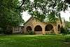 |
(#93000118) |
401 N. Rusk 29°18′49″N 96°05′52″W / 29.31372°N 96.09783°W |
Wharton | |
| 2 | Moses Bernstein House | Upload image | (#93000116) |
1705 N. Richmond 29°19′35″N 96°05′51″W / 29.326310°N 96.097411°W |
Wharton | |
| 3 | Bolton-Outlar House | 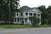 |
(#93000108) |
517 N. Richmond 29°18′57″N 96°06′05″W / 29.315778°N 96.101265°W |
Wharton | |
| 4 | Colorado River Bridge | 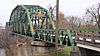 |
(#93000117) |
S. Richmond Rd. (Old US 59) across the Colorado R. 29°18′30″N 96°06′13″W / 29.308333°N 96.103611°W |
Wharton | |
| 5 | Wiley J. Croom House |  |
(#93000099) |
205 E. Milam 29°18′38″N 96°05′55″W / 29.31067°N 96.0987232°W |
Wharton | |
| 6 | F. F. Dannon House | Upload image | (#93000095) |
612 W. Caney 29°18′49″N 96°06′19″W / 29.313652°N 96.105228°W |
Wharton | |
| 7 | Dr. Green Davidson House | 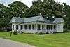 |
(#93000111) |
404 Bolton 29°18′56″N 96°06′07″W / 29.315528°N 96.102028°W |
Wharton | |
| 8 | Ben and Mary Davis House |  |
(#93000104) |
100 S. Resident 29°18′37″N 96°05′54″W / 29.31015°N 96.09823°W |
Wharton | |
| 9 | Nettie Elkins House |  |
(#93000114) |
109 E. Alabama 29°18′50″N 96°05′54″W / 29.313833°N 96.09831°W |
Wharton | |
| 10 | E. Clyde and Mary Elliott House |  |
(#93000122) |
707 N. Walnut 29°18′57″N 96°05′37″W / 29.315827°N 96.093736°W |
Wharton | |
| 11 | Old First Methodist Episcopal Church South |  |
(#93000097) |
200 N. Fulton 29°18′46″N 96°05′56″W / 29.312814°N 96.099025°W |
Wharton | |
| 12 | Henry B. Garrett House |  |
(#93000098) |
504 N. Fulton 29°18′56″N 96°05′46″W / 29.315588°N 96.096045°W |
Wharton | |
| 13 | John A. and Sophie Garrett House |  |
(#93000115) |
401 E. Alabama 29°18′47″N 96°05′44″W / 29.313023°N 96.095449°W |
Wharton | |
| 14 | George C. and Annie Gifford House |  |
(#93000096) |
615 W. Caney 29°18′47″N 96°06′20″W / 29.313165°N 96.105469°W |
Wharton | |
| 15 | Joseph Andrew Hamilton House |  |
(#93000106) |
325 N. Richmond 29°18′53″N 96°06′09″W / 29.314819°N 96.102451°W |
Wharton | |
| 16 | Gerard A. Harrison House |  |
(#93000112) |
209 E. Caney 29°18′42″N 96°05′53″W / 29.311564°N 96.098016°W |
Wharton | |
| 17 | Harrison-Dennis House |  |
(#93000110) |
409 W. Burleson 29°18′38″N 96°06′13″W / 29.310556°N 96.103611°W |
Wharton | |
| 18 | Edwin Hawes House |  |
(#93000102) |
309 N. Resident 29°18′45″N 96°05′50″W / 29.312602°N 96.0973°W |
Wharton | |
| 19 | Edwin Hawes Jr. House | Upload image | (#93000105) |
119 S. Resident 29°18′34″N 96°05′51″W / 29.309444°N 96.0975°W |
Wharton | Demolished |
| 20 | House at 401 North Richmond |  |
(#93000107) |
401 N. Richmond 29°18′54″N 96°06′08″W / 29.315127°N 96.102120°W |
Wharton | |
| 21 | House at 512 North Resident |  |
(#93000103) |
512 N. Resident 29°18′54″N 96°05′43″W / 29.315°N 96.095278°W |
Wharton | |
| 22 | Linn Street Historic District |  |
(#93000124) |
Roughly, the 500 blocks of Richmond Rd. and Houston St. and the 100-200 blocks of Linn St. 29°18′56″N 96°05′59″W / 29.315556°N 96.099722°W |
Wharton | |
| 23 | Merrell-Roten House |  |
(#93000113) |
520 Ave. A 29°18′56″N 96°05′34″W / 29.315494°N 96.092711°W |
Wharton | |
| 24 | Moran-Moore House |  |
(#93000120) |
501 N. Walnut 29°18′51″N 96°05′40″W / 29.314037°N 96.094410°W |
Wharton | |
| 25 | J. H. Speaker House |  |
(#93000109) |
414 E. Alabama 29°18′45″N 96°05′42″W / 29.312404°N 96.095117°W |
Wharton | |
| 26 | St. John's Evangelical Lutheran Church |  |
(#93000100) |
612 N. Pecan 29°18′55″N 96°05′40″W / 29.315284°N 96.094576°W |
Wharton | |
| 27 | Texas and New Orleans Railroad Bridge | 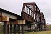 |
(#93000123) |
Southern Pacific RR tracks, 0.25 mi (0.40 km). W of Old US 59, over the Colorado R. 29°18′26″N 96°06′23″W / 29.307222°N 96.106389°W |
Wharton | |
| 28 | Texas and New Orleans Railroad Depot | 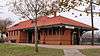 |
(#93000119) |
100 block of N. Sunset 29°18′49″N 96°06′23″W / 29.31364°N 96.10638°W |
Wharton | |
| 29 | West Milam Street Mercantile Historic District | 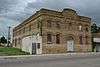 |
(#93000125) |
Roughly 637-668 W. Milam St. 29°18′46″N 96°06′23″W / 29.312833°N 96.106368°W |
Wharton | |
| 30 | Wharton County Courthouse Historic Commercial District |  |
(#91001624) |
Roughly bounded by the alley N of Milam St., Rusk St., Elm St. and Richmond St. 29°18′38″N 96°06′03″W / 29.31055°N 96.10083°W |
Wharton | |
| 31 | Louis F. Worthing House | 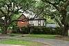 |
(#93000121) |
620 N. Walnut 29°18′55″N 96°05′36″W / 29.315147°N 96.093348°W |
Wharton |
See also
| Wikimedia Commons has media related to National Register of Historic Places in Wharton County, Texas. |
References
- ↑ The latitude and longitude information provided in this table was derived originally from the National Register Information System, which has been found to be fairly accurate for about 99% of listings. For about 1% of NRIS original coordinates, experience has shown that one or both coordinates are typos or otherwise extremely far off; some corrections may have been made. A more subtle problem causes many locations to be off by up to 150 yards, depending on location in the country: most NRIS coordinates were derived from tracing out latitude and longitudes off of USGS topographical quadrant maps created under the North American Datum of 1927, which differs from the current, highly accurate WGS84 GPS system used by most on-line maps. Chicago is about right, but NRIS longitudes in Washington are higher by about 4.5 seconds, and are lower by about 2.0 seconds in Maine. Latitudes differ by about 1.0 second in Florida. Some locations in this table may have been corrected to current GPS standards.
- ↑ "National Register of Historic Places: Weekly List Actions". National Park Service, United States Department of the Interior. Retrieved on December 2, 2016.
- ↑ Numbers represent an ordering by significant words. Various colorings, defined here, differentiate National Historic Landmarks and historic districts from other NRHP buildings, structures, sites or objects.
- ↑ National Park Service (2008-04-24). "National Register Information System". National Register of Historic Places. National Park Service.
- ↑ The eight-digit number below each date is the number assigned to each location in the National Register Information System database, which can be viewed by clicking the number.
| Topics | |
|---|---|
| Lists by states |
|
| Lists by insular areas | |
| Lists by associated states | |
| Other areas | |
| |
This article is issued from Wikipedia - version of the 7/3/2016. The text is available under the Creative Commons Attribution/Share Alike but additional terms may apply for the media files.