| [3] |
Name on the Register[4] |
Image |
Date listed[5] |
Location |
City or town |
Description |
|---|
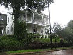
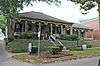
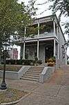
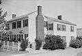
| 1 |
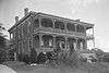
1300 Grove Street House |
Upload image |
000000001983-11-29-0000November 29, 1983
(#83003976) |
1300 Grove St.
32°21′03″N 90°52′28″W / 32.350833°N 90.874444°W / 32.350833; -90.874444 (1300 Grove Street House) |
Vicksburg |
|
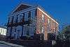
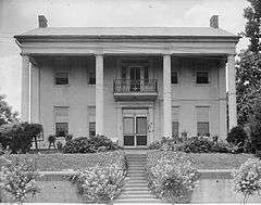
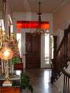
| 2 |
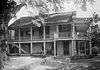
Anchuca |
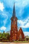
|
000000001982-03-22-0000March 22, 1982
(#82003113) |
1010 1st E. St.
32°21′16″N 90°52′38″W / 32.354444°N 90.877222°W / 32.354444; -90.877222 (Anchuca) |
Vicksburg |
|
| 3 |
Anshe Chesed Cemetery |
Upload image |
000000002014-09-10-0000September 10, 2014
(#14000569) |
Grove St.
32°20′43″N 90°51′14″W / 32.3454°N 90.8539°W / 32.3454; -90.8539 (Anshe Chesed Cemetery) |
Vicksburg |
|
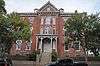
| 4 |
Balfour House |
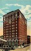
|
000000001971-10-26-0000October 26, 1971
(#71000458) |
1002 Crawford St.
32°20′51″N 90°52′43″W / 32.3475°N 90.878611°W / 32.3475; -90.878611 (Balfour House) |
Vicksburg |
|
| 5 |
Beck House |
Upload image |
000000001979-03-29-0000March 29, 1979
(#79001336) |
1101 South St.
32°20′52″N 90°52′38″W / 32.347778°N 90.877222°W / 32.347778; -90.877222 (Beck House) |
Vicksburg |
|
| 6 |
Belle Fleur |
Upload image |
000000001992-05-07-0000May 7, 1992
(#92000469) |
1123 South St.
32°20′52″N 90°53′17″W / 32.347778°N 90.888056°W / 32.347778; -90.888056 (Belle Fleur) |
Vicksburg |
|
| 7 |
Bethel African Methodist Episcopal Church |
Upload image |
000000001992-07-30-0000July 30, 1992
(#92000858) |
805 Monroe St.
32°21′16″N 90°52′44″W / 32.354444°N 90.878889°W / 32.354444; -90.878889 (Bethel African Methodist Episcopal Church) |
Vicksburg |
|
| 8 |
Beulah Cemetery |
Upload image |
000000001992-10-23-0000October 23, 1992
(#92001404) |
Junction of Openwood St. and Old Jackson Rd.
32°21′26″N 90°50′59″W / 32.357222°N 90.849722°W / 32.357222; -90.849722 (Beulah Cemetery) |
Vicksburg |
|
| 9 |
Biedenharn Candy Company Building |
|
000000001977-12-02-0000December 2, 1977
(#77000793) |
1107-1109 Washington St.
32°21′05″N 90°52′53″W / 32.351389°N 90.881389°W / 32.351389; -90.881389 (Biedenharn Candy Company Building) |
Vicksburg |
|
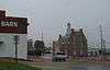
| 10 |
Big Black River Battlefield |
|
000000001971-11-23-0000November 23, 1971
(#71000451) |
On both banks of the Big Black River between Smith's Station and Bovina
32°21′36″N 90°43′35″W / 32.36°N 90.726389°W / 32.36; -90.726389 (Big Black River Battlefield) |
Bovina |
Extends into Hinds County
|
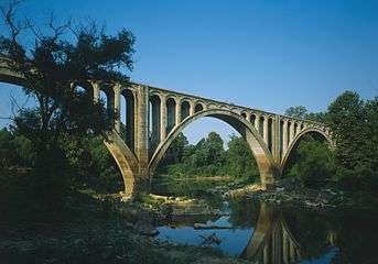
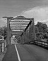
| 11 |
Big Black River Railroad Bridge |
|
000000001988-11-16-0000November 16, 1988
(#88002418) |
Spans the Big Black River east of Bovina
32°20′49″N 90°42′17″W / 32.346944°N 90.704722°W / 32.346944; -90.704722 (Big Black River Railroad Bridge) |
Bovina |
Extends into Hinds County
|
| 12 |
Blum House |
Upload image |
000000001992-07-30-0000July 30, 1992
(#92000859) |
1420 Cherry St.
31°37′36″N 90°53′45″W / 31.626667°N 90.895833°W / 31.626667; -90.895833 (Blum House) |
Vicksburg |
|
| 13 |
Bobb House |
Upload image |
000000001979-01-08-0000January 8, 1979
(#79001337) |
1503 Harrison St.
32°20′45″N 90°52′21″W / 32.345833°N 90.8725°W / 32.345833; -90.8725 (Bobb House) |
Vicksburg |
|
| 14 |
Isaac Bonham House |
Upload image |
000000001977-05-26-0000May 26, 1977
(#77000794) |
601 Klein St.
32°20′29″N 90°53′06″W / 32.341389°N 90.885°W / 32.341389; -90.885 (Isaac Bonham House) |
Vicksburg |
|
| 15 |
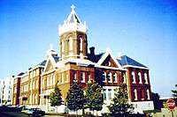
Carr Junior High School |
Upload image |
000000002002-04-05-0000April 5, 2002
(#00001055) |
1805 Cherry St.
32°20′41″N 90°52′42″W / 32.344722°N 90.878333°W / 32.344722; -90.878333 (Carr Junior High School) |
Vicksburg |
|
| 16 |
Cedar Grove |
|
000000001976-07-19-0000July 19, 1976
(#76001107) |
2200 Oak St.
32°20′25″N 90°53′08″W / 32.340278°N 90.885556°W / 32.340278; -90.885556 (Cedar Grove) |
Vicksburg |
|
| 17 |
Chickasaw Bayou Battlefield |
Upload image |
000000001973-04-24-0000April 24, 1973
(#73001028) |
North of Vicksburg on U.S. Route 61
32°24′45″N 90°51′24″W / 32.4125°N 90.856667°W / 32.4125; -90.856667 (Chickasaw Bayou Battlefield) |
Vicksburg |
Site of the Battle of Chickasaw Bayou
|
| 18 |
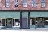
Christian and Brough Building |
Upload image |
000000002014-06-02-0000June 2, 2014
(#14000278) |
923 Washington St.
32°21′12″N 90°52′53″W / 32.35329°N 90.881404°W / 32.35329; -90.881404 (Christian and Brough Building) |
Vicksburg |
|
| 19 |
Church of the Holy Trinity |
|
000000001978-05-22-0000May 22, 1978
(#78001633) |
South and Monroe Sts.
32°20′50″N 90°52′47″W / 32.347222°N 90.879722°W / 32.347222; -90.879722 (Church of the Holy Trinity) |
Vicksburg |
|
| 20 |
Confederate Avenue Brick Arch Bridge |
Upload image |
000000001988-11-16-0000November 16, 1988
(#88002421) |
Confederate Ave.
32°19′44″N 90°52′31″W / 32.328889°N 90.875278°W / 32.328889; -90.875278 (Confederate Avenue Brick Arch Bridge) |
Vicksburg |
|
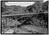
| 21 |
Craig-Flowers House |
|
000000001984-08-02-0000August 2, 1984
(#84002352) |
2011 Cherry St.
32°20′29″N 90°52′43″W / 32.341389°N 90.878611°W / 32.341389; -90.878611 (Craig-Flowers House) |
Vicksburg |
|
| 22 |
Davis-Mitchell House |
|
000000001982-06-01-0000June 1, 1982
(#82003114) |
901 Crawford St.
32°20′57″N 90°52′46″W / 32.349167°N 90.879444°W / 32.349167; -90.879444 (Davis-Mitchell House) |
Vicksburg |
|
| 23 |
Fairground Street Bridge |
|
000000001988-11-16-0000November 16, 1988
(#88002420) |
Spans the Illinois Central railroad yard on Fairground St.
32°20′16″N 90°53′25″W / 32.337778°N 90.890278°W / 32.337778; -90.890278 (Fairground Street Bridge) |
Vicksburg |
|
| 24 |
Federal Fortifications Along Bear Creek |
Upload image |
000000001974-08-30-0000August 30, 1974
(#74001066) |
Southwest of Youngton
32°25′40″N 90°38′06″W / 32.427778°N 90.635°W / 32.427778; -90.635 (Federal Fortifications Along Bear Creek) |
Youngton |
|
| 25 |
Feld House |
Upload image |
000000001982-08-02-0000August 2, 1982
(#82003115) |
2108 Cherry St.
32°20′26″N 90°52′46″W / 32.340556°N 90.879444°W / 32.340556; -90.879444 (Feld House) |
Vicksburg |
|
| 26 |
Fitz-Hugh Hall |
Upload image |
000000001986-11-06-0000November 6, 1986
(#86003030) |
1322 Chambers St.
32°20′18″N 90°52′41″W / 32.338333°N 90.878056°W / 32.338333; -90.878056 (Fitz-Hugh Hall) |
Vicksburg |
|
| 27 |
Col. Charles C. Flowerree House |
|
000000001975-05-29-0000May 29, 1975
(#75001058) |
2309 Pearl St.
32°20′25″N 90°53′14″W / 32.340278°N 90.887222°W / 32.340278; -90.887222 (Col. Charles C. Flowerree House) |
Vicksburg |
|
| 28 |
Fonsylvania |
Upload image |
000000001984-09-07-0000September 7, 1984
(#84002355) |
Fisher Ferry Rd., south of Vicksburg
32°11′33″N 90°49′14″W / 32.1925°N 90.820556°W / 32.1925; -90.820556 (Fonsylvania) |
Vicksburg |
|
| 29 |
Fort St. Pierre Site |
Upload image |
000000002000-02-16-0000February 16, 2000
(#00000263) |
Off U.S. Route 61 north of Vicksburg[6]
32°29′44″N 90°47′55″W / 32.4956°N 90.7986°W / 32.4956; -90.7986 (Fort St. Pierre Site) |
Vicksburg |
|
| 30 |
The Galleries |
Upload image |
000000001980-04-17-0000April 17, 1980
(#80002303) |
2421 Marshall St.
32°20′14″N 90°53′04″W / 32.337222°N 90.884444°W / 32.337222; -90.884444 (The Galleries) |
Vicksburg |
|
| 31 |
Glenwood-Vicklan Historic District |
Upload image |
000000002009-11-03-0000November 3, 2009
(#09000886) |
Including Vicklan St., Glenwood Cir., Edna Dr., and Chambers St. east of the bayou
32°20′20″N 90°52′14″W / 32.338778°N 90.87065°W / 32.338778; -90.87065 (Glenwood-Vicklan Historic District) |
Vicksburg |
|
| 32 |
Duff Green House |
|
000000001979-01-11-0000January 11, 1979
(#79001338) |
806 Locust St.
32°21′15″N 90°52′32″W / 32.354167°N 90.875556°W / 32.354167; -90.875556 (Duff Green House) |
Vicksburg |
|
| 33 |
Grove Street Houses |
Upload image |
000000001980-05-08-0000May 8, 1980
(#80002304) |
1117 and 1121 Grove St.
32°21′06″N 90°52′34″W / 32.351667°N 90.876111°W / 32.351667; -90.876111 (Grove Street Houses) |
Vicksburg |
|
| 34 |
Grove Street-Jackson Historic District |
|
000000002007-11-21-0000November 21, 2007
(#05001613) |
Along Grove and Jackson Sts. between Cherry St. and 1st N. St.
32°21′07″N 90°52′33″W / 32.351856°N 90.875906°W / 32.351856; -90.875906 (Grove Street-Jackson Historic District) |
Vicksburg |
|
| 35 |
Guider House |
Upload image |
000000001980-05-08-0000May 8, 1980
(#80002305) |
1115 Grove St.
32°21′05″N 90°52′35″W / 32.351389°N 90.876389°W / 32.351389; -90.876389 (Guider House) |
Vicksburg |
|
| 36 |
P.M. Harding House |
Upload image |
000000001986-07-17-0000July 17, 1986
(#86001674) |
1402 Chambers St.
32°20′18″N 90°52′35″W / 32.338333°N 90.876389°W / 32.338333; -90.876389 (P.M. Harding House) |
Vicksburg |
|
| 37 |
Hotel Vicksburg |
|
000000001979-06-04-0000June 4, 1979
(#79001339) |
801 Clay St.
32°21′00″N 90°52′50″W / 32.35°N 90.880556°W / 32.35; -90.880556 (Hotel Vicksburg) |
Vicksburg |
|
| 38 |
Joel and Margaret Hullum House |
Upload image |
000000001984-07-05-0000July 5, 1984
(#84002358) |
749 Mallet Rd.
32°12′47″N 90°52′27″W / 32.213056°N 90.874167°W / 32.213056; -90.874167 (Joel and Margaret Hullum House) |
Vicksburg |
|
| 39 |
Hyland Mound Archeological Site |
Upload image |
000000002001-08-30-0000August 30, 2001
(#01000920) |
Address Restricted
|
Vicksburg |
|
| 40 |
Fannie Willis Johnson House |
Upload image |
000000001988-04-08-0000April 8, 1988
(#88000241) |
2430 Drummond St.
32°20′09″N 90°52′54″W / 32.335833°N 90.881667°W / 32.335833; -90.881667 (Fannie Willis Johnson House) |
Vicksburg |
|
| 41 |
Dr. Isaac Cecil Knox House |
Upload image |
000000001990-09-18-0000September 18, 1990
(#90001478) |
2823 Confederate Ave.
32°19′14″N 90°53′02″W / 32.320556°N 90.883889°W / 32.320556; -90.883889 (Dr. Isaac Cecil Knox House) |
Vicksburg |
|
| 42 |
John Lane House |
|
000000001982-05-06-0000May 6, 1982
(#82003116) |
905 Crawford St.
32°20′56″N 90°52′45″W / 32.348889°N 90.879167°W / 32.348889; -90.879167 (John Lane House) |
Vicksburg |
|
| 43 |
W.W. Lassiter Wholesale Grocery Warehouse |
Upload image |
000000001994-03-07-0000March 7, 1994
(#94000149) |
1308 Levee St.
32°21′01″N 90°53′03″W / 32.350278°N 90.884167°W / 32.350278; -90.884167 (W.W. Lassiter Wholesale Grocery Warehouse) |
Vicksburg |
|
| 44 |
Loosa Yokena Archeological Site |
Upload image |
000000002001-05-08-0000May 8, 2001
(#01000481) |
Address Restricted
|
Kimberly |
|
| 45 |
Luckett Compound |
|
000000001983-07-28-0000July 28, 1983
(#83000968) |
1116-1122 Crawford St
32°20′53″N 90°52′36″W / 32.348056°N 90.876667°W / 32.348056; -90.876667 (Luckett Compound) |
Vicksburg |
|
| 46 |
The Magnolias |
Upload image |
000000001987-02-26-0000February 26, 1987
(#87000217) |
1617 Monroe St.
32°20′43″N 90°52′49″W / 32.345278°N 90.880278°W / 32.345278; -90.880278 (The Magnolias) |
Vicksburg |
|
| 47 |
Magruder-Morrissey House |
Upload image |
000000001984-05-24-0000May 24, 1984
(#84002361) |
1117 Cherry St.
32°21′03″N 90°52′40″W / 32.350833°N 90.877778°W / 32.350833; -90.877778 (Magruder-Morrissey House) |
Vicksburg |
|
| 48 |
Main Street Historic District |
|
000000001979-04-16-0000April 16, 1979
(#79001340) |
1st East, Adams, Main, and Openwoods Sts.; also roughly bounded by Adams St., Main St., Cherry St., and 1st East St.
32°21′12″N 90°52′32″W / 32.353333°N 90.875556°W / 32.353333; -90.875556 (Main Street Historic District) |
Vicksburg |
Second set of boundaries represents a boundary increase of 000000001989-01-05-0000January 5, 1989
|
| 49 |
McDermott House |
Upload image |
000000001984-07-12-0000July 12, 1984
(#84002359) |
1100 South St.
32°20′50″N 90°52′40″W / 32.347222°N 90.877778°W / 32.347222; -90.877778 (McDermott House) |
Vicksburg |
|
| 50 |
McNutt House |
|
000000001975-05-29-0000May 29, 1975
(#75001059) |
Northwestern corner of Monroe and E. 1st Sts.
32°21′17″N 90°52′45″W / 32.354722°N 90.879167°W / 32.354722; -90.879167 (McNutt House) |
Vicksburg |
|
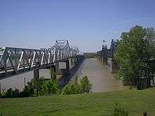
| 51 |
Mississippi River Bridge |
|
000000001989-02-14-0000February 14, 1989
(#88002423) |
Spans the Mississippi River on Old U.S. Route 80
32°18′54″N 90°54′20″W / 32.315°N 90.905556°W / 32.315; -90.905556 (Mississippi River Bridge) |
Vicksburg |
Extends into Madison Parish, Louisiana
|
| 52 |
Old Courthouse, Warren County |
|
000000001968-05-23-0000May 23, 1968
(#68000029) |
Court Sq.
32°21′07″N 90°52′43″W / 32.351944°N 90.878611°W / 32.351944; -90.878611 (Old Courthouse, Warren County) |
Vicksburg |
|
| 53 |
Pemberton's Headquarters |
|
000000001970-07-23-0000July 23, 1970
(#70000319) |
1018 Crawford St.
32°20′54″N 90°52′40″W / 32.348333°N 90.877778°W / 32.348333; -90.877778 (Pemberton's Headquarters) |
Vicksburg |
|
| 54 |
Planters Hall |
|
000000001971-06-21-0000June 21, 1971
(#71000459) |
822 Main St.
32°21′14″N 90°52′46″W / 32.353889°N 90.879444°W / 32.353889; -90.879444 (Planters Hall) |
Vicksburg |
|
| 55 |
Adolph Rose Building |
Upload image |
000000001992-11-12-0000November 12, 1992
(#92001567) |
717 Clay St.
32°21′01″N 90°52′55″W / 32.350278°N 90.881944°W / 32.350278; -90.881944 (Adolph Rose Building) |
Vicksburg |
|
| 56 |
St. Francis Xavier Convent |
|
000000001977-04-18-0000April 18, 1977
(#77000796) |
1021 Crawford St.
32°20′55″N 90°52′39″W / 32.348611°N 90.8775°W / 32.348611; -90.8775 (St. Francis Xavier Convent) |
Vicksburg |
|
| 57 |
Shlenker House |
Upload image |
000000001983-11-17-0000November 17, 1983
(#83003975) |
2212 Cherry St.
32°20′19″N 90°52′45″W / 32.338611°N 90.879167°W / 32.338611; -90.879167 (Shlenker House) |
Vicksburg |
|
| 58 |
Snyder's Bluff |
Upload image |
000000001973-02-06-0000February 6, 1973
(#73001027) |
Along the Yazoo River north of Redwood[7]
32°29′51″N 90°47′53″W / 32.4975°N 90.7981°W / 32.4975; -90.7981 (Snyder's Bluff) |
Redwood |
|
| 59 |
South Cherry Street Historic District |
|
000000002003-11-14-0000November 14, 2003
(#03001140) |
Along Cherry and Drummond Sts. from Harrison St. to Bowmar St. and including Chambers and Baum Sts.
32°20′25″N 90°52′42″W / 32.340278°N 90.878333°W / 32.340278; -90.878333 (South Cherry Street Historic District) |
Vicksburg |
|
| 60 |
South Drummond Street Neighborhood Historic District |
Upload image |
000000002015-09-28-0000September 28, 2015
(#15000667) |
Roughly bounded by Bowmar & Confederate Aves., Yerger, Green, 2nd, Oak Hill & Polk Sts., Halls Ferry Rd.
32°19′52″N 90°53′08″W / 32.331°N 90.8855°W / 32.331; -90.8855 (South Drummond Street Neighborhood Historic District) |
Vicksburg |
|
| 61 |
South Vicksburg Public School No. 200 |
Upload image |
000000001986-03-20-0000March 20, 1986
(#86000482) |
900 Speed St.
32°20′18″N 90°53′06″W / 32.338333°N 90.885°W / 32.338333; -90.885 (South Vicksburg Public School No. 200) |
Vicksburg |
|
| 62 |
Uptown Vicksburg Historic District |
|
000000001993-08-19-0000August 19, 1993
(#93000850) |
Roughly bounded by Locust, South, Washington, and Clay Sts.; also mostly on Washington St. between Grove and Veto Sts.
32°20′55″N 90°52′45″W / 32.348611°N 90.879167°W / 32.348611; -90.879167 (Uptown Vicksburg Historic District) |
Vicksburg |
Second set of boundaries represents a boundary increase of 000000002004-09-10-0000September 10, 2004
|
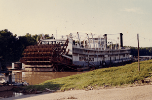
| 63 |
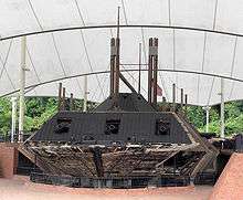
U.S.S. CAIRO |
|
000000001971-09-03-0000September 3, 1971
(#71000068) |
U.S.S. Cairo Museum
32°22′33″N 90°52′00″W / 32.375833°N 90.866667°W / 32.375833; -90.866667 (U.S.S. CAIRO) |
Vicksburg |
|
| 64 |
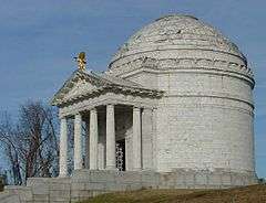
Vicksburg National Military Park |
|
000000001966-10-15-0000October 15, 1966
(#66000100) |
North and east of Vicksburg
32°20′28″N 90°51′44″W / 32.341111°N 90.862222°W / 32.341111; -90.862222 (Vicksburg National Military Park) |
Vicksburg |
|
| 65 |
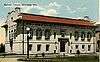
Old Vicksburg Public Library |
|
000000001992-07-30-0000July 30, 1992
(#92000857) |
819 South St.
32°20′53″N 90°52′51″W / 32.348056°N 90.880833°W / 32.348056; -90.880833 (Old Vicksburg Public Library) |
Vicksburg |
|
| 66 |
Vicksburg Siege Cave |
Upload image |
000000001973-03-14-0000March 14, 1973
(#73001029) |
Near the Vicksburg City Cemetery
32°21′59″N 90°51′41″W / 32.366389°N 90.861389°W / 32.366389; -90.861389 (Vicksburg Siege Cave) |
Vicksburg |
|
| 67 |
Walnut Hills |
|
000000001982-03-19-0000March 19, 1982
(#82003117) |
1214 Adams St.
32°20′59″N 90°52′39″W / 32.349722°N 90.8775°W / 32.349722; -90.8775 (Walnut Hills) |
Vicksburg |
|
| 68 |
Waterways Experiment Station |
Upload image |
000000002000-12-13-0000December 13, 2000
(#00001511) |
Roughly bounded by Spillway, Durden Creek, Tennessee Rd., and Dam Spillway
32°17′50″N 90°52′10″W / 32.297222°N 90.869444°W / 32.297222; -90.869444 (Waterways Experiment Station) |
Vicksburg |
|
| 69 |
Yazoo And Mississippi Valley Depot |
|
000000001979-11-13-0000November 13, 1979
(#79001341) |
500 Grove St.
32°21′09″N 90°52′59″W / 32.352553°N 90.882924°W / 32.352553; -90.882924 (Yazoo And Mississippi Valley Depot) |
Vicksburg |
|
| 70 |
Yokena Presbyterian Church |
Upload image |
000000001984-09-07-0000September 7, 1984
(#84002442) |
South of Vicksburg on U.S. Route 61
32°10′24″N 90°56′31″W / 32.173333°N 90.941944°W / 32.173333; -90.941944 (Yokena Presbyterian Church) |
Vicksburg |
|
| 71 |
Young-Bradfield House |
|
000000001982-05-06-0000May 6, 1982
(#82003118) |
913 Crawford St.
32°20′56″N 90°52′44″W / 32.348889°N 90.878889°W / 32.348889; -90.878889 (Young-Bradfield House) |
Vicksburg |
|

.jpg)
.jpg)


.jpg)