National Register of Historic Places listings in Walworth County, South Dakota

Location of Walworth County in South Dakota
This is a list of the National Register of Historic Places listings in Walworth County, South Dakota.
This is intended to be a complete list of the properties on the National Register of Historic Places in Walworth County, South Dakota, United States. The locations of National Register properties for which the latitude and longitude coordinates are included below, may be seen in a map.[1]
There are 13 properties listed on the National Register in the county.
- This National Park Service list is complete through NPS recent listings posted December 2, 2016.[2]
Current listings
| [3] | Name on the Register[4] | Image | Date listed[5] | Location | City or town | Description |
|---|---|---|---|---|---|---|
| 1 | Brown Palace Hotel | Upload image | (#83003022) |
301 Main St. 45°32′08″N 100°26′02″W / 45.535556°N 100.433889°W |
Mobridge | |
| 2 | A. H. Brown Public Library | 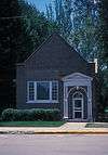 |
(#78002573) |
N. Main St. 45°32′17″N 100°26′02″W / 45.538056°N 100.433889°W |
Mobridge | |
| 3 | Brown-Evans House | Upload image | (#90000960) |
405 1st Ave., W. 45°32′12″N 100°26′07″W / 45.536667°N 100.435278°W |
Mobridge | |
| 4 | Gravel Pit Site (39WW203) | Upload image | (#86000834) |
Address Restricted |
Mobridge | |
| 5 | Java Depot | Upload image | (#01000640) |
Northwestern corner of Railway Ave. and Main St. 45°30′17″N 99°53′12″W / 45.504722°N 99.886667°W |
Java | |
| 6 | Johnson Barn | Upload image | (#05000950) |
Approximately 4 miles west-northwest of Glenham 45°32′55″N 100°21′36″W / 45.548611°N 100.36°W |
Mobridge | |
| 7 | Mobridge Auditorium |  |
(#86001189) |
212 Main St. 45°32′10″N 100°25′58″W / 45.536111°N 100.432778°W |
Mobridge | |
| 8 | Mobridge Masonic Temple | 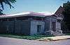 |
(#77001259) |
6th and Main Sts. 45°32′17″N 100°26′00″W / 45.538056°N 100.433333°W |
Mobridge | |
| 9 | Molstad Lake Park | Upload image | (#10000953) |
1¾ mi. north of US 12 on 293rd Ave. 45°33′38″N 100°18′20″W / 45.560556°N 100.305556°W |
Glenham | Federal Relief Construction in South Dakota MPS |
| 10 | Wilhelm Moser House-Barn | Upload image | (#84001299) |
North of Java in the middle of the western half of Section 6, T124, R74W[6] Coordinates missing |
Java | |
| 11 | Jacob Ochszbner Sr. House | Upload image | (#84003421) |
North of Java in the southern half of Section 18, T124N, R75W[6] Coordinates missing |
Java | |
| 12 | Selby Opera House | Upload image | (#87001730) |
3409 Main St. 45°30′23″N 100°01′06″W / 45.506389°N 100.018333°W |
Selby | |
| 13 | Walworth County Courthouse | Upload image | (#99000680) |
4304 4th Ave. 45°30′25″N 100°02′03″W / 45.506944°N 100.034167°W |
Selby |
See also
| Wikimedia Commons has media related to National Register of Historic Places in Walworth County, South Dakota. |
- List of National Historic Landmarks in South Dakota
- National Register of Historic Places listings in South Dakota
References
- ↑ The latitude and longitude information provided in this table was derived originally from the National Register Information System, which has been found to be fairly accurate for about 99% of listings. For about 1% of NRIS original coordinates, experience has shown that one or both coordinates are typos or otherwise extremely far off; some corrections may have been made. A more subtle problem causes many locations to be off by up to 150 yards, depending on location in the country: most NRIS coordinates were derived from tracing out latitude and longitudes off of USGS topographical quadrant maps created under the North American Datum of 1927, which differs from the current, highly accurate WGS84 GPS system used by most on-line maps. Chicago is about right, but NRIS longitudes in Washington are higher by about 4.5 seconds, and are lower by about 2.0 seconds in Maine. Latitudes differ by about 1.0 second in Florida. Some locations in this table may have been corrected to current GPS standards.
- ↑ "National Register of Historic Places: Weekly List Actions". National Park Service, United States Department of the Interior. Retrieved on December 2, 2016.
- ↑ Numbers represent an ordering by significant words. Various colorings, defined here, differentiate National Historic Landmarks and historic districts from other NRHP buildings, structures, sites or objects.
- ↑ National Park Service (2008-04-24). "National Register Information System". National Register of Historic Places. National Park Service.
- ↑ The eight-digit number below each date is the number assigned to each location in the National Register Information System database, which can be viewed by clicking the number.
- 1 2 Location derived from its NRHP nomination form; the NRIS lists it as "Address Restricted"
| Topics | |
|---|---|
| Lists by states |
|
| Lists by insular areas | |
| Lists by associated states | |
| Other areas | |
| |
Municipalities and communities of Walworth County, South Dakota, United States | ||
|---|---|---|
| Cities | | |
| Towns | ||
This article is issued from Wikipedia - version of the 5/9/2016. The text is available under the Creative Commons Attribution/Share Alike but additional terms may apply for the media files.