National Register of Historic Places listings in Trumbull County, Ohio

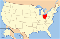
Location of Trumbull County in Ohio
This is a list of the National Register of Historic Places listings in Trumbull County, Ohio.
This is intended to be a complete list of the properties and districts on the National Register of Historic Places in Trumbull County, Ohio, United States. The locations of National Register properties and districts for which the latitude and longitude coordinates are included below, may be seen in an online map.[1]
There are 35 properties and districts listed on the National Register in the county, including 1 National Historic Landmark. Another property was once listed but has been removed.
- This National Park Service list is complete through NPS recent listings posted December 2, 2016.[2]
Current listings
| [3] | Name on the Register[4] | Image | Date listed[5] | Location | City or town | Description |
|---|---|---|---|---|---|---|
| 1 | Dr. Peter Allen House | .jpg) |
(#71000653) |
W. Williamsfield State Rd., north of its intersection with State Route 87, in Kinsman 41°27′17″N 80°35′41″W / 41.454722°N 80.594722°W |
Kinsman Township | |
| 2 | Henry Barnhisel, II House | 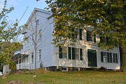 |
(#82001492) |
1011 N. State St. 41°09′52″N 80°42′19″W / 41.164444°N 80.705278°W |
Girard | |
| 3 | Brookfield Center Historic District |  |
(#85002922) |
Roughly the western side of State Route 7 from Sharon-Warren Rd. to N. Wood St. and Brookfield Village Green 41°13′59″N 80°34′06″W / 41.233056°N 80.568333°W |
Brookfield Township | |
| 4 | Charles Brown Gothic Cottage |  |
(#75001545) |
State Route 45, S. in North Bloomfield 41°27′36″N 80°52′08″W / 41.460000°N 80.868889°W |
Bloomfield Township | |
| 5 | Brown-Wing House |  |
(#75001546) |
Park West Rd. in North Bloomfield 41°27′50″N 80°52′29″W / 41.463889°N 80.874722°W |
Bloomfield Township | |
| 6 | Brownwood | 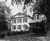 |
(#71000655) |
State Route 45 in North Bloomfield 41°27′39″N 80°51′21″W / 41.460833°N 80.855833°W |
Bloomfield Township | |
| 7 | Congregational-Presbyterian Church | 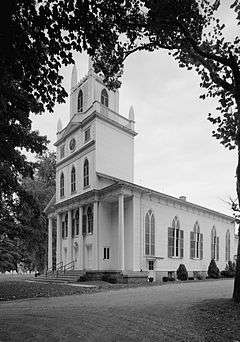 |
(#71000654) |
Near State Routes 5 and 7 in Kinsman 41°26′56″N 80°35′21″W / 41.448889°N 80.589167°W |
Kinsman Township | |
| 8 | Clarence Darrow Octagon House | 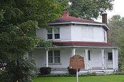 |
(#71001025) |
State Routes 5 and 7 in Kinsman 41°26′59″N 80°35′04″W / 41.449722°N 80.584444°W |
Kinsman Township | |
| 9 | John Stark Edwards House | 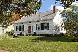 |
(#78002199) |
309 South St., SE. 41°14′03″N 80°49′00″W / 41.234167°N 80.816667°W |
Warren | |
| 10 | Fowler Center Historic District | 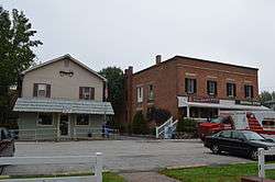 |
(#85002921) |
Roughly the area around the Fowler Township Village Green at the junction of State Routes 193 and 305, in Fowler 41°18′39″N 80°39′23″W / 41.310833°N 80.656389°W |
Fowler Township | |
| 11 | Richard Garlick House | 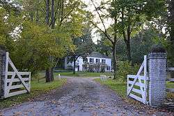 |
(#90001500) |
1025 Ravine Dr., north of Youngstown 41°08′49″N 80°38′36″W / 41.146944°N 80.643333°W |
Liberty Township | |
| 12 | Greene Township Center | 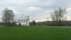 |
(#78002198) |
East of North Bloomfield on State Route 87 at Greene Center 41°27′41″N 80°45′44″W / 41.461389°N 80.762222°W |
Greene Township | |
| 13 | Gustavus Center Historic District | 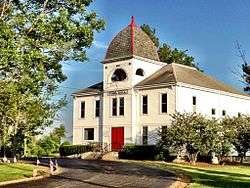 |
(#75001542) |
Town of Gustavus situated at the junction of State Routes 87 and 193 41°27′42″N 80°39′56″W / 41.461667°N 80.665556°W |
Gustavus Township | |
| 14 | Charles Harshman House | 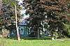 |
(#83002062) |
3932 Painesville-Warren State Rd., NW. 41°19′35″N 80°56′39″W / 41.326389°N 80.944167°W |
Southington Township | |
| 15 | Elam Jones Public House | 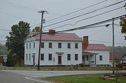 |
(#02001687) |
3365 State Route 7 in Hartford 41°18′43″N 80°34′05″W / 41.311806°N 80.568056°W |
Hartford Township | |
| 16 | Mahoning Avenue Historic District | 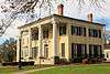 |
(#71000656) |
241-391 Mahoning Ave., NW.; also Mahoning Ave. between Perkins Dr. and High St. 41°14′19″N 80°49′22″W / 41.238611°N 80.822778°W |
Warren | Second set of boundaries represents a boundary increase |
| 17 | John Wesley Mason Gothic Cottage | 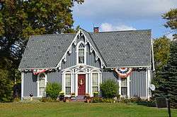 |
(#75001541) |
Northwest of Braceville on State Route 534 41°14′49″N 80°58′33″W / 41.246806°N 80.975972°W |
Braceville Township | |
| 18 | Almon G. McCorkle House | 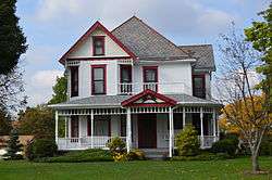 |
(#82003659) |
1180 Salt Springs Rd. 41°09′59″N 80°50′28″W / 41.166389°N 80.841111°W |
Lordstown | |
| 19 | McKinley Memorial |  |
(#75001544) |
40 N. Main St. 41°10′51″N 80°45′58″W / 41.180833°N 80.766111°W |
Niles | Beaux-Arts memorial to President McKinley designed by McKim, Mead & White. |
| 20 | McLain-Gillmer House | 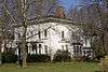 |
(#78002200) |
720 Mahoning Ave., NW. 41°14′30″N 80°49′29″W / 41.241667°N 80.824722°W |
Warren | |
| 21 | Mesopotamia Village District | 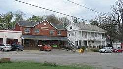 |
(#74001635) |
State Routes 87 and 534 at Mesopotamia 41°27′37″N 80°57′16″W / 41.460278°N 80.954444°W |
Mesopotamia Township | |
| 22 | Newton Falls Covered Bridge | 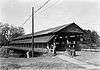 |
(#74001636) |
Off State Route 534 41°11′17″N 80°58′17″W / 41.188056°N 80.971389°W |
Newton Falls | |
| 23 | Niles Masonic Temple | 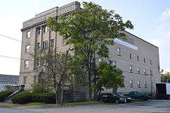 |
(#06000274) |
22 W. Church St. 41°10′55″N 80°45′58″W / 41.181944°N 80.766111°W |
Niles | |
| 24 | James Ward Packard House |  |
(#85003577) |
319 Oak Knoll Ave., NE. 41°14′21″N 80°47′38″W / 41.239167°N 80.793889°W |
Warren | |
| 25 | Liberty G. Raymond Tavern and Barn |  |
(#75001543) |
State Route 87 and Dennison-Ashtabula Rd. in Kenilworth 41°27′44″N 80°44′18″W / 41.462222°N 80.738333°W |
Greene Township | |
| 26 | Dr. John W. Seely House | 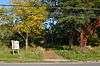 |
(#72001048) |
2245 Niles-Cortland Rd., south of Howland Corners 41°12′45″N 80°44′24″W / 41.212500°N 80.740000°W |
Howland Township | |
| 27 | Southington Township School | 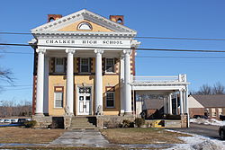 |
(#10001214) |
4432 State Route 305 41°18′30″N 80°57′27″W / 41.308333°N 80.9575°W |
Southington Township | Originally listed as Chalker High School (10001214),[6] renamed Southington Township School and boundary expanded (12000464)[7] based on Ohio request to add adjacent elementary school and Civil War memorial.[8] |
| 28 | Swift-Kinsman House | Upload image | (#16000114) |
8426 State Rd. 41°27′02″N 80°35′27″W / 41.450556°N 80.590833°W |
Kinsman Township | |
| 29 | Trumbull County Courthouse |  |
(#74001637) |
160 High St., NW. 41°14′13″N 80°49′09″W / 41.236944°N 80.819167°W |
Warren | |
| 30 | Harriet Taylor Upton House | 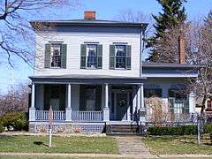 |
(#92001884) |
380 Mahoning Ave., NW. 41°14′22″N 80°49′21″W / 41.239444°N 80.8225°W |
Warren | |
| 31 | Ward-Thomas House |  |
(#84003809) |
503 Brown St. 41°10′26″N 80°45′53″W / 41.173889°N 80.764722°W |
Niles | |
| 32 | Warren Commercial Historic District | 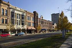 |
(#83002063) |
Roughly bounded by Mahoning, Monroe, Franklin, and Pine Sts. 41°14′17″N 80°49′13″W / 41.238056°N 80.820278°W |
Warren | |
| 33 | Warren Public Library |  |
(#73001543) |
120 High St., NW. 41°14′15″N 80°49′06″W / 41.2375°N 80.818333°W |
Warren | |
| 34 | Wells-Clark-Strouss House | 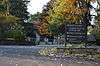 |
(#93000877) |
50 Warner Rd. at Logan Rd., east of Churchill 41°10′19″N 80°37′55″W / 41.171944°N 80.631944°W |
Liberty Township | |
| 35 | William Woodrow House | 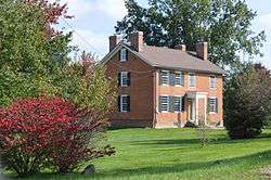 |
(#82003658) |
138 Champion St., E., in Champion Heights 41°17′28″N 80°50′44″W / 41.291111°N 80.845556°W |
Champion Township |
Former listing
| [3] | Name on the Register | Image | Date listed | Date removed | Location | City or town | Summary |
|---|---|---|---|---|---|---|---|
| 1 | Augustus Elwell House | Upload image | (#75001540) | Northwest of Braceville on State Route 82 |
Braceville |
See also
| Wikimedia Commons has media related to National Register of Historic Places in Trumbull County, Ohio. |
References
- ↑ The latitude and longitude information provided in this table was derived originally from the National Register Information System, which has been found to be fairly accurate for about 99% of listings. For about 1% of NRIS original coordinates, experience has shown that one or both coordinates are typos or otherwise extremely far off; some corrections may have been made. A more subtle problem causes many locations to be off by up to 150 yards, depending on location in the country: most NRIS coordinates were derived from tracing out latitude and longitudes off of USGS topographical quadrant maps created under the North American Datum of 1927, which differs from the current, highly accurate WGS84 GPS system used by most on-line maps. Chicago is about right, but NRIS longitudes in Washington are higher by about 4.5 seconds, and are lower by about 2.0 seconds in Maine. Latitudes differ by about 1.0 second in Florida. Some locations in this table may have been corrected to current GPS standards.
- ↑ "National Register of Historic Places: Weekly List Actions". National Park Service, United States Department of the Interior. Retrieved on December 2, 2016.
- 1 2 Numbers represent an ordering by significant words. Various colorings, defined here, differentiate National Historic Landmarks and historic districts from other NRHP buildings, structures, sites or objects.
- ↑ National Park Service (2008-04-24). "National Register Information System". National Register of Historic Places. National Park Service.
- ↑ The eight-digit number below each date is the number assigned to each location in the National Register Information System database, which can be viewed by clicking the number.
- ↑ "Weekly list of actions taken on properties: 1/31/11 through 2/04/11". National Park Service. February 11, 2011. Retrieved September 3, 2015.
- ↑ "Weekly list of actions taken on properties: 7/30/12 through 8/03/12". National Park Service. August 10, 2012. Retrieved September 3, 2015.
- ↑ "Board recommends change to Southington historic site". Vindy.com. Archived from the original on 2012-04-21. Retrieved 3 September 2015.

Municipalities and communities of Trumbull County, Ohio, United States | ||
|---|---|---|
| Cities | | |
| Villages | ||
| Townships | ||
| CDPs |
| |
| Unincorporated communities | ||
| Footnotes | ‡This populated place also has portions in an adjacent county or counties | |
This article is issued from Wikipedia - version of the 9/11/2016. The text is available under the Creative Commons Attribution/Share Alike but additional terms may apply for the media files.