| [3] |
Name on the Register |
Image |
Date listed[4] |
Location |
City or town |
Description |
|---|
| 1 |
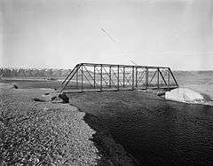
Araphoe and Lost Creek Site (48SW4882) |
Upload image |
000000001986-03-12-0000March 12, 1986
(#86000352) |
Address restricted
|
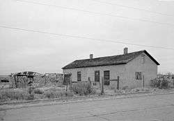
Hadsell Cabin |
|
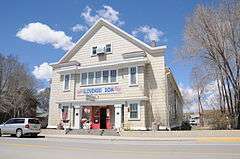
| 2 |
Bairoil Town Hall |
Upload image |
000000002015-11-30-0000November 30, 2015
(#15000858) |
505 Antelope Dr.
42°14′34″N 107°33′35″W / 42.2428°N 107.5598°W / 42.2428; -107.5598 (Bairoil Town Hall) |
Bairoil |
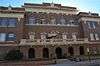
|
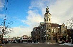
| 3 |
City Hall |
|
000000001980-05-15-0000May 15, 1980
(#80004053) |
4th and B Sts.
41°35′06″N 109°13′14″W / 41.585°N 109.220556°W / 41.585; -109.220556 (City Hall) |
Rock Springs |
|
| 4 |
Dean Decker Site (48FR916; 48SW541) |
Upload image |
000000001986-03-12-0000March 12, 1986
(#86000354) |
Address restricted
|
Honeycomb Buttes |
Extends into Fremont County
|
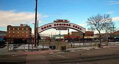
| 5 |
Downtown Rock Springs Historic District |
|
000000001994-01-19-0000January 19, 1994
(#93001492) |
Roughly bounded by K, 4th, C, 2nd, A, and 5th Sts.
41°35′13″N 109°13′11″W / 41.586944°N 109.219722°W / 41.586944; -109.219722 (Downtown Rock Springs Historic District) |
Rock Springs |
|
| 6 |
Dug Springs Station Site |
Upload image |
000000001977-09-22-0000September 22, 1977
(#77001384) |
Address restricted
|
Rock Springs |
|
| 7 |
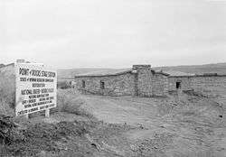
Eden-Farson Site |
Upload image |
000000002014-09-22-0000September 22, 2014
(#14000710) |
Address restricted
|
Eden vicinity |
|
| 8 |
Eldon-Wall Terrace Site (48SW4320) |
Upload image |
000000001985-12-13-0000December 13, 1985
(#85003223) |
Address restricted
|
Westvaco |
|
| 9 |
ETD Bridge over Green River |
|
000000001985-02-22-0000February 22, 1985
(#85000439) |
County Road CN4-8SS
41°58′49″N 110°02′43″W / 41.980278°N 110.045278°W / 41.980278; -110.045278 (ETD Bridge over Green River) |
Fontenelle |
|
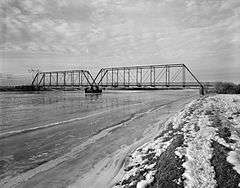
| 10 |
ETR Big Island Bridge |
|
000000001985-02-22-0000February 22, 1985
(#85000440) |
County Road CN4-4
41°45′52″N 109°44′05″W / 41.764444°N 109.734722°W / 41.764444; -109.734722 (ETR Big Island Bridge) |
Green River |
|
| 11 |
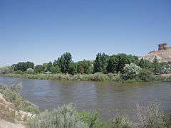
Expedition Island |
|
000000001968-11-24-0000November 24, 1968
(#68000056) |
South of the Union Pacific railroad bridge, near the eastern bank of the Green River
41°31′28″N 109°28′19″W / 41.524444°N 109.471944°W / 41.524444; -109.471944 (Expedition Island) |
Green River |
|
| 12 |
The Finley Site |
Upload image |
000000002010-11-17-0000November 17, 2010
(#10000929) |
4 miles southeast of Eden
Coordinates missing |
Eden |
|
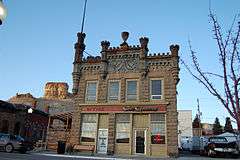
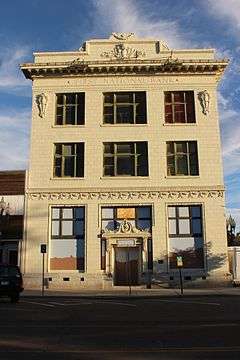
| 13 |
First National Bank Building |
|
000000001980-03-13-0000March 13, 1980
(#80004054) |
502 S. Main St.
41°35′30″N 109°13′12″W / 41.591667°N 109.22°W / 41.591667; -109.22 (First National Bank Building) |
Rock Springs |
|
| 14 |
Granger Station |
|
000000001970-02-26-0000February 26, 1970
(#70000678) |
In Granger
41°35′25″N 109°58′08″W / 41.590278°N 109.968889°W / 41.590278; -109.968889 (Granger Station) |
Granger |
|
| 15 |
Gras House |
|
000000001986-03-13-0000March 13, 1986
(#86000355) |
616 W. Elias
41°35′24″N 109°13′10″W / 41.59°N 109.219444°W / 41.59; -109.219444 (Gras House) |
Rock Springs |
|
| 16 |
Green River Downtown Historic District |
Upload image |
000000002009-01-08-0000January 8, 2009
(#08001306) |
72-142 Flaming Gorge Way, 58-94 N. 1st St., 125-200 E. Railroad Ave., 62-94 N. 1st E. St., and the pedestrian overpass
41°31′42″N 109°27′59″W / 41.52847°N 109.46634°W / 41.52847; -109.46634 (Green River Downtown Historic District) |
Green River |
|
| 17 |
Laclede Station Ruin |
|
000000001978-12-06-0000December 6, 1978
(#78002833) |
Off BLM Road 4409 along Bitter Creek, southeast of the community of Bitter Creek[5]
41°25′21″N 108°24′45″W / 41.422500°N 108.412500°W / 41.422500; -108.412500 (Laclede Station Ruin) |
Rock Springs |
|
| 18 |
Natural Corrals Archeological Site (48SW336) |
Upload image |
000000001987-08-17-0000August 17, 1987
(#87000873) |
Address restricted
|
Superior |
|
| 19 |
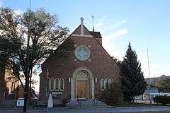
Our Lady of Sorrows Catholic Church |
|
000000001997-11-06-0000November 6, 1997
(#97001326) |
A at Broadway
41°34′58″N 109°13′18″W / 41.582778°N 109.221667°W / 41.582778; -109.221667 (Our Lady of Sorrows Catholic Church) |
Rock Springs |
|
| 20 |
Parting of the Ways |
Upload image |
000000001976-01-11-0000January 11, 1976
(#76001962) |
15 miles northeast of Farson
42°15′27″N 109°13′42″W / 42.2575°N 109.228333°W / 42.2575; -109.228333 (Parting of the Ways) |
Farson |
|
| 21 |
Point of Rocks Stage Station |
|
000000001970-04-03-0000April 3, 1970
(#70000679) |
Off Interstate 80
41°40′30″N 108°47′30″W / 41.675°N 108.791667°W / 41.675; -108.791667 (Point of Rocks Stage Station) |
Rock Springs |
|
| 22 |
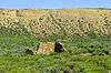
Red Rock |
Upload image |
000000001978-11-21-0000November 21, 1978
(#78002832) |
Southwest of Rawlins
41°25′46″N 108°00′05″W / 41.429444°N 108.001389°W / 41.429444; -108.001389 (Red Rock) |
Rawlins |
|
| 23 |
Reliance School and Gymnasium |
|
000000001988-05-13-0000May 13, 1988
(#87002303) |
1321 Main St.
41°39′38″N 109°11′31″W / 41.660556°N 109.191944°W / 41.660556; -109.191944 (Reliance School and Gymnasium) |
Reliance |
|
| 24 |
Reliance Tipple |
|
000000001991-05-23-0000May 23, 1991
(#91000619) |
East of U.S. Route 187
41°40′05″N 109°11′46″W / 41.668056°N 109.196111°W / 41.668056; -109.196111 (Reliance Tipple) |
Reliance |
|
| 25 |
Rock Springs Elks' Lodge No. 624 |
|
000000001993-12-10-0000December 10, 1993
(#93001383) |
307 C St.
41°35′03″N 109°13′07″W / 41.584167°N 109.218611°W / 41.584167; -109.218611 (Rock Springs Elks' Lodge No. 624) |
Rock Springs |
|
| 26 |
Saints Cyril and Methodius Catholic Church and Rectory |
Upload image |
000000002015-12-22-0000December 22, 2015
(#15000929) |
633 Bridger Ave.
41°35′29″N 109°13′12″W / 41.591304°N 109.219958°W / 41.591304; -109.219958 (Saints Cyril and Methodius Catholic Church and Rectory) |
Rock Springs |
|
| 26 |
Slovenski Dom |
|
000000001997-12-30-0000December 30, 1997
(#97001601) |
513 Bridger Ave.
41°35′29″N 109°13′15″W / 41.591389°N 109.220833°W / 41.591389; -109.220833 (Slovenski Dom) |
Rock Springs |
|
| 27 |
South Superior Union Hall |
|
000000001983-11-25-0000November 25, 1983
(#83004305) |
Main and Bridge Sts.
41°45′45″N 108°58′03″W / 41.7625°N 108.9675°W / 41.7625; -108.9675 (South Superior Union Hall) |
Superior |
|
| 28 |
Elinore Pruitt Stewart Homestead |
Upload image |
000000001985-04-25-0000April 25, 1985
(#85000871) |
Off Wyoming Highway 414
41°00′44″N 109°59′35″W / 41.012222°N 109.993056°W / 41.012222; -109.993056 (Elinore Pruitt Stewart Homestead) |
McKinnon |
|
| 29 |
Sweetwater Brewery |
|
000000001982-11-01-0000November 1, 1982
(#82001838) |
48 W. Railroad Ave.
41°31′44″N 109°28′05″W / 41.528889°N 109.468056°W / 41.528889; -109.468056 (Sweetwater Brewery) |
Green River |
|
| 30 |
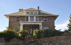
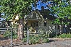
Taliaferro House |
|
000000001998-07-23-0000July 23, 1998
(#98000909) |
106 Cedar St.
41°34′53″N 109°13′07″W / 41.581389°N 109.218611°W / 41.581389; -109.218611 (Taliaferro House) |
Rock Springs |
|
| 31 |
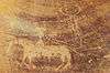
Tolar Petroglyph Site |
|
000000002014-09-30-0000September 30, 2014
(#14000822) |
Address Restricted
|
Point of Rocks vicinity |
|
| 32 |
US Post Office-Green River |
Upload image |
000000001997-12-11-0000December 11, 1997
(#97001535) |
3 W. Flaming Gorge Way
41°30′42″N 109°27′31″W / 41.511667°N 109.458611°W / 41.511667; -109.458611 (US Post Office-Green River) |
Green River |
|
| 33 |
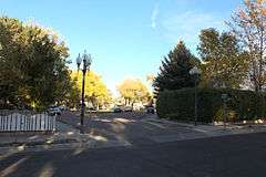
Wardell Court Historic Residential District |
|
000000001997-01-30-0000January 30, 1997
(#96001630) |
Wardell Court at its junction with D St.
41°34′56″N 109°12′50″W / 41.582222°N 109.213889°W / 41.582222; -109.213889 (Wardell Court Historic Residential District) |
Rock Springs |
|

.jpg)
_from_South_Street.jpg)