National Register of Historic Places listings in Sublette County, Wyoming
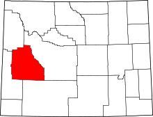
Location of Sublette County in Wyoming
This is a list of the National Register of Historic Places listings in Sublette County, Wyoming. It is intended to be a complete list of the properties and districts on the National Register of Historic Places in Sublette County, Wyoming, United States. The locations of National Register properties and districts for which the latitude and longitude coordinates are included below, may be seen in a map.[1]
There are 20 properties and districts listed on the National Register in the county, 1 of which is a National Historic Landmark.
- This National Park Service list is complete through NPS recent listings posted December 2, 2016.[2]
Listings county-wide
| [3] |
Name on the Register |
Image |
Date listed[4] |
Location |
City or town |
Description |
|---|
| 1 |
Calpet Rockshelter |
Upload image |
000000001994-05-13-0000May 13, 1994
(#94000439) |
Address Restricted
|
Big Piney |
|
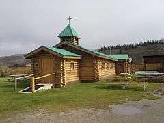
| 2 |
Church of St. Hubert the Hunter and Library |
|
000000002002-01-24-0000January 24, 2002
(#01001525) |
U.S. Routes 189 and 191
43°12′05″N 110°24′22″W / 43.201389°N 110.406111°W / 43.201389; -110.406111 (Church of St. Hubert the Hunter and Library) |
Bondurant |
|
| 3 |
Circle Ranch |
Upload image |
000000001987-05-14-0000May 14, 1987
(#87000778) |
4 miles southwest of Big Piney off Wyoming Highway 350
42°31′19″N 110°10′49″W / 42.521944°N 110.180278°W / 42.521944; -110.180278 (Circle Ranch) |
Big Piney |
|
| 4 |
Craig Cabin |
Upload image |
000000002016-09-19-0000September 19, 2016
(#16000648) |
Approx. 4 miles (6.4 km) E. of Dell & Jack Creeks
Coordinates missing |
Bondurant vicinity |
|
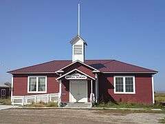
| 5 |
Daniel School |
|
000000001990-09-05-0000September 5, 1990
(#90001387) |
U.S. Route 189
42°51′53″N 110°04′29″W / 42.864722°N 110.074722°W / 42.864722; -110.074722 (Daniel School) |
Daniel |
|
| 6 |
DDZ Bridge over New Fork River |
|
000000001985-02-22-0000February 22, 1985
(#85000437) |
County Road 136
42°45′02″N 109°43′33″W / 42.750556°N 109.725833°W / 42.750556; -109.725833 (DDZ Bridge over New Fork River) |
Boulder |
|
| 7 |
ENP Bridge over Green River |
|
000000001985-02-22-0000February 22, 1985
(#85000438) |
County Road CN23-145
42°46′47″N 109°58′07″W / 42.779722°N 109.968611°W / 42.779722; -109.968611 (ENP Bridge over Green River) |
Daniel |
|
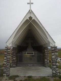
| 8 |
Father DeSmet's Prairie Mass Site |
|
000000001970-04-28-0000April 28, 1970
(#70000676) |
Off U.S. Route 187
42°52′10″N 110°02′29″W / 42.869444°N 110.041389°W / 42.869444; -110.041389 (Father DeSmet's Prairie Mass Site) |
Daniel |
|
| 9 |
Fort Bonneville |
Upload image |
000000001970-04-28-0000April 28, 1970
(#70000677) |
Off U.S. Route 189
42°53′40″N 110°08′03″W / 42.894444°N 110.134167°W / 42.894444; -110.134167 (Fort Bonneville) |
Pinedale |
|
| 10 |
Green River Drift Trail Traditional Cultural Property |
Upload image |
000000002013-11-22-0000November 22, 2013
(#12001224) |
Generally follows upper Green River
42°54′50″N 109°58′44″W / 42.913944°N 109.979008°W / 42.913944; -109.979008 (Green River Drift Trail Traditional Cultural Property) |
Cora |
|
| 11 |
Jensen Ranch |
Upload image |
000000001988-05-05-0000May 5, 1988
(#88000552) |
Martin Jensen County Rd.
42°38′22″N 109°31′28″W / 42.639444°N 109.524444°W / 42.639444; -109.524444 (Jensen Ranch) |
Boulder |
|
| 12 |
Log Cabin Motel |
|
000000001993-03-25-0000March 25, 1993
(#93000230) |
49 E. Magnolia St.
42°52′04″N 109°51′34″W / 42.867778°N 109.859444°W / 42.867778; -109.859444 (Log Cabin Motel) |
Pinedale |
|
| 13 |
New Fork |
Upload image |
000000001987-07-16-0000July 16, 1987
(#87000773) |
3 miles south of Boulder on U.S. Route 187
42°42′13″N 109°42′55″W / 42.703611°N 109.715278°W / 42.703611; -109.715278 (New Fork) |
Boulder |
|
| 14 |
Redick Lodge |
Upload image |
000000001983-03-18-0000March 18, 1983
(#83003364) |
North of Pinedale
42°59′34″N 109°48′08″W / 42.992778°N 109.802222°W / 42.992778; -109.802222 (Redick Lodge) |
Pinedale |
|
| 15 |
Sommers Ranch Headquarters Historic District |
Upload image |
000000002009-06-18-0000June 18, 2009
(#09000454) |
734 County Road 23-110
Coordinates missing |
Pinedale |
|
| 16 |
Steele Homestead |
Upload image |
000000001985-04-25-0000April 25, 1985
(#85000870) |
Wyoming Highway 191
42°45′17″N 109°37′14″W / 42.754722°N 109.620556°W / 42.754722; -109.620556 (Steele Homestead) |
Boulder |
|
| 17 |
Trappers Point Site |
Upload image |
000000002007-05-14-0000May 14, 2007
(#07000368) |
6 miles (9.7 km) west of Pinedale[5]
42°52′47″N 109°58′57″W / 42.879722°N 109.982500°W / 42.879722; -109.982500 (Trappers Point Site) |
Pinedale |
|
| 18 |
Union Pass |
Upload image |
000000001969-04-16-0000April 16, 1969
(#69000367) |
On the Continental Divide in Teton National Forest
43°28′54″N 109°52′24″W / 43.481667°N 109.873333°W / 43.481667; -109.873333 (Union Pass) |
Unknown |
|
| 19 |
Upper Green River Rendezvous Site |
|
000000001966-10-15-0000October 15, 1966
(#66000763) |
On the Green River above and below Daniel
42°52′25″N 110°02′14″W / 42.873611°N 110.037222°W / 42.873611; -110.037222 (Upper Green River Rendezvous Site) |
Daniel |
|
| 20 |
Wardell Buffalo Trap |
Upload image |
000000001971-08-12-0000August 12, 1971
(#71000892) |
Address Restricted
|
Big Piney |
|
See also
References
- ↑ The latitude and longitude information provided in this table was derived originally from the National Register Information System, which has been found to be fairly accurate for about 99% of listings. For about 1% of NRIS original coordinates, experience has shown that one or both coordinates are typos or otherwise extremely far off; some corrections may have been made. A more subtle problem causes many locations to be off by up to 150 yards, depending on location in the country: most NRIS coordinates were derived from tracing out latitude and longitudes off of USGS topographical quadrant maps created under the North American Datum of 1927, which differs from the current, highly accurate WGS84 GPS system used by most on-line maps. Chicago is about right, but NRIS longitudes in Washington are higher by about 4.5 seconds, and are lower by about 2.0 seconds in Maine. Latitudes differ by about 1.0 second in Florida. Some locations in this table may have been corrected to current GPS standards.
- ↑ "National Register of Historic Places: Weekly List Actions". National Park Service, United States Department of the Interior. Retrieved on December 2, 2016.
- ↑ Numbers represent an ordering by significant words. Various colorings, defined here, differentiate National Historic Landmarks and historic districts from other NRHP buildings, structures, sites or objects.
- ↑ The eight-digit number below each date is the number assigned to each location in the National Register Information System database, which can be viewed by clicking the number.
- ↑ Miller, Mark E., and Paul H. Sanders. "The Tappers Point Site (48SU1006): Early Archaic Adaptations and Pronghorn Procurement in the Upper Green River Basin, Wyoming". Plains Anthropologist 45.174 (2000): 39-52: 46.
|
|---|
|
| Topics | |
|---|
|
| Lists by states | |
|---|
|
| Lists by insular areas | |
|---|
|
| Lists by associated states | |
|---|
|
| Other areas | |
|---|
|
-
 Portal Portal
-
 WikiProject WikiProject
|