National Register of Historic Places listings in Stephenson County, Illinois
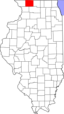
Location of Stephenson County in Illinois
This is a list of the National Register of Historic Places listings in Stephenson County, Illinois.
This is intended to be a complete list of the properties and districts on the National Register of Historic Places in Stephenson County, Illinois, United States. Latitude and longitude coordinates are provided for many National Register properties and districts; these locations may be seen together in a map.[1]
There are 17 properties and districts listed on the National Register in the county.
- This National Park Service list is complete through NPS recent listings posted December 16, 2016.[2]
Current listings
| [3] |
Name on the Register |
Image |
Date listed[4] |
Location |
City or town |
Description |
|---|
| 1 |
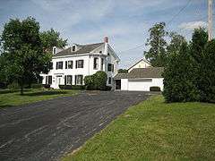
John H. Addams Homestead |
|
000000001979-04-17-0000April 17, 1979
(#79000871) |
425 N. Mill St.
42°23′26″N 89°38′16″W / 42.390556°N 89.637778°W / 42.390556; -89.637778 (John H. Addams Homestead) |
Cedarville |
|
| 2 |
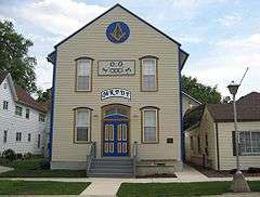
AF and AM Lodge 687, Orangeville |
|
000000002003-05-09-0000May 9, 2003
(#03000354) |
203 W. High St.
42°28′06″N 89°38′44″W / 42.468333°N 89.645556°W / 42.468333; -89.645556 (AF and AM Lodge 687, Orangeville) |
Orangeville |
|
| 3 |
James Bruce Round Barn |
|
000000001984-02-23-0000February 23, 1984
(#84001157) |
S of Freeport
42°15′07″N 89°38′57″W / 42.251944°N 89.649167°W / 42.251944; -89.649167 (James Bruce Round Barn) |
Freeport |
|
| 4 |
Central House |
|
000000001999-05-20-0000May 20, 1999
(#99000585) |
210 W. High St.
42°28′09″N 89°38′47″W / 42.469167°N 89.646389°W / 42.469167; -89.646389 (Central House) |
Orangeville |
|
| 5 |
Charles Fehr Round Barn |
|
000000001984-02-23-0000February 23, 1984
(#84001152) |
NE of Orangeville
42°29′46″N 89°31′20″W / 42.496111°N 89.522222°W / 42.496111; -89.522222 (Charles Fehr Round Barn) |
Orangeville |
|
| 6 |
Freeport City Hall |
|
000000002016-06-07-0000June 7, 2016
(#16000329) |
230 W. Stephenson St.
42°17′51″N 89°37′24″W / 42.297495°N 89.623231°W / 42.297495; -89.623231 (Freeport City Hall) |
Freeport |
|
| 7 |
Gerald Harbach Round Barn |
|
000000001984-02-23-0000February 23, 1984
(#84001155) |
US 20
42°19′40″N 89°44′04″W / 42.327778°N 89.734444°W / 42.327778; -89.734444 (Gerald Harbach Round Barn) |
Eleroy |
|
| 8 |
Chris Jensen Round Barn |
Upload image |
000000001984-02-23-0000February 23, 1984
(#84001150) |
11723 W. Galena Rd.
42°23′30″N 89°50′06″W / 42.391667°N 89.835°W / 42.391667; -89.835 (Chris Jensen Round Barn) |
Lena |
Demolished[5]
|
| 9 |
Kellogg's Grove |
|
000000001978-06-23-0000June 23, 1978
(#78001191) |
SE of Kent
42°17′46″N 89°53′13″W / 42.296111°N 89.886944°W / 42.296111; -89.886944 (Kellogg's Grove) |
Kent |
|
| 10 |
Lena Water Tower |
|
000000001997-02-20-0000February 20, 1997
(#97000034) |
201 Vernon St.
42°22′49″N 89°49′41″W / 42.380278°N 89.828056°W / 42.380278; -89.828056 (Lena Water Tower) |
Lena |
|
| 11 |
Dennis Otte Round Barn |
|
000000001984-02-23-0000February 23, 1984
(#84001164) |
E of Eleroy
42°20′01″N 89°44′16″W / 42.333611°N 89.737778°W / 42.333611; -89.737778 (Dennis Otte Round Barn) |
Eleroy |
|
| 12 |
People's State Bank |
|
000000002004-08-20-0000August 20, 2004
(#04000868) |
300 W. High St.
42°28′15″N 89°38′49″W / 42.470833°N 89.646944°W / 42.470833; -89.646944 (People's State Bank) |
Orangeville |
|
| 13 |
William Ritzman House |
|
000000002000-10-27-0000October 27, 2000
(#00000949) |
10715 IL 26 N
42°27′33″N 89°38′30″W / 42.459167°N 89.641667°W / 42.459167; -89.641667 (William Ritzman House) |
Orangeville |
|
| 14 |
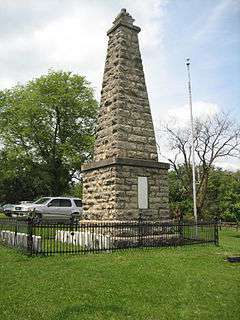
Soldiers' Monument |
|
000000001998-06-01-0000June 1, 1998
(#98000461) |
15 N. Galena Ave.
42°17′52″N 89°37′19″W / 42.297778°N 89.621944°W / 42.297778; -89.621944 (Soldiers' Monument) |
Freeport |
|
| 15 |
Stephenson County Courthouse |
|
000000001974-01-17-0000January 17, 1974
(#74002284) |
Courthouse Sq.
42°17′53″N 89°37′19″W / 42.298056°N 89.621944°W / 42.298056; -89.621944 (Stephenson County Courthouse) |
Freeport |
Demolished; the building shown is the new courthouse, which was built on the site of the old one
|
| 16 |
Oscar Taylor House |
|
000000001984-05-11-0000May 11, 1984
(#84001165) |
1440 S. Carroll Ave.
42°17′04″N 89°36′54″W / 42.284444°N 89.615°W / 42.284444; -89.615 (Oscar Taylor House) |
Freeport |
|
| 17 |
Union House |
|
000000002000-05-11-0000May 11, 2000
(#00000472) |
207 W. High St.
42°28′06″N 89°38′45″W / 42.468333°N 89.645833°W / 42.468333; -89.645833 (Union House) |
Orangeville |
|
| [3] |
Name on the Register |
Image |
Date listed | Date removed |
Location |
City or town |
Summary |
|---|
| 1 |
Clyde Leek Round Barn |
Upload image |
000000001984-02-23-0000February 23, 1984
(#84001161) | 000000001995-12-08-0000December 8, 1995 |
N Dakota Rd.
|
Dakota |
|
See also
References
- ↑ The latitude and longitude information provided in this table was derived originally from the National Register Information System, which has been found to be fairly accurate for about 99% of listings. For about 1% of NRIS original coordinates, experience has shown that one or both coordinates are typos or otherwise extremely far off; some corrections may have been made. A more subtle problem causes many locations to be off by up to 150 yards, depending on location in the country: most NRIS coordinates were derived from tracing out latitude and longitudes off of USGS topographical quadrant maps created under the North American Datum of 1927, which differs from the current, highly accurate WGS84 GPS system used by most on-line maps. Chicago is about right, but NRIS longitudes in Washington are higher by about 4.5 seconds, and are lower by about 2.0 seconds in Maine. Latitudes differ by about 1.0 second in Florida. Some locations in this table may have been corrected to current GPS standards.
- ↑ "National Register of Historic Places: Weekly List Actions". National Park Service, United States Department of the Interior. Retrieved on December 16, 2016.
- 1 2 Numbers represent an ordering by significant words. Various colorings, defined here, differentiate National Historic Landmarks and historic districts from other NRHP buildings, structures, sites or objects.
- ↑ The eight-digit number below each date is the number assigned to each location in the National Register Information System database, which can be viewed by clicking the number.
- ↑ Travis, Dale. "Illinois Round Barns List". Retrieved June 18, 2015.
|
|---|
|
| Topics | |
|---|
|
| Lists by states | |
|---|
|
| Lists by insular areas | |
|---|
|
| Lists by associated states | |
|---|
|
| Other areas | |
|---|
|
-
 Portal Portal
-
 WikiProject WikiProject
|