| [1] |
Name on the Register |
Image |
Date listed[2] |
Location |
Quadrant |
Description |
|---|
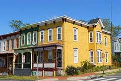
| 1 |
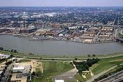
Anacostia Historic District |
|
000000001978-10-11-0000October 11, 1978
(#78003050) |
Roughly bounded by Martin Luther King, Jr. Avenue; Good Hope Road; 16th Street; Fendall Street; V Street; 15th Street and the Frederick Douglass National Historic Site; Maple View Place
38°51′53″N 76°59′08″W / 38.864722°N 76.985556°W / 38.864722; -76.985556 (Anacostia Historic District) |
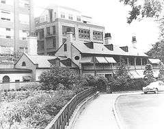
SE |
Comprises approximately 20 squares and about 550 buildings built between 1854 and 1930
|
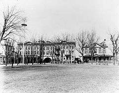
| 2 |
Capitol Hill Historic District |
|
000000001976-08-27-0000August 27, 1976
(#76002127) |
Roughly bounded by Virginia Ave., SE., S. Capitol St., F St. NE., and 14th Sts. SE & NE.
38°53′13″N 76°59′51″W / 38.886944°N 76.9975°W / 38.886944; -76.9975 (Capitol Hill Historic District) |
NE, SE and NW |
Boundary increase (listed July 3, 2003): Roughly bounded by 7th St. NE, I-295, M St. SE and 11th St. SE
|
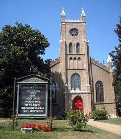
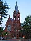
| 3 |
Christ Church |
|
000000001969-05-25-0000May 25, 1969
(#69000291) |
620 G St., SE.
38°52′53″N 76°59′52″W / 38.881389°N 76.997778°W / 38.881389; -76.997778 (Christ Church) |
SE |
|
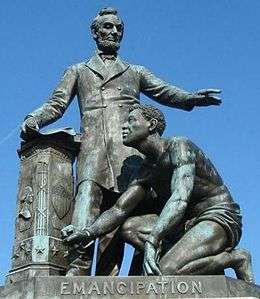
| 4 |
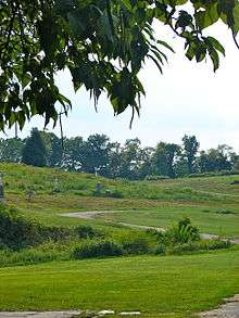
Civil War Monuments in Washington, DC |
|
000000001978-09-20-0000September 20, 1978
(#78000257) |
Various parks within the original boundaries of city
38°53′23″N 76°59′25″W / 38.889722°N 76.990278°W / 38.889722; -76.990278 (Civil War Monuments in Washington, DC) |
Various |
18 statues about people and topics related to the Civil War, including 1 in Lincoln Park (NE & SE quadrants), 6 in the upper NW quadrant, and 11 in central Washington.
|
| 5 |
Commandant's Office, Washington Navy Yard |
|
000000001973-08-14-0000August 14, 1973
(#73002077) |
Montgomery Sq. and Dahlgren Ave., SE.
38°52′23″N 76°59′43″W / 38.873056°N 76.995278°W / 38.873056; -76.995278 (Commandant's Office, Washington Navy Yard) |
SE |
See Washington Navy Yard
|
| 6 |
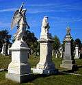
Congressional Cemetery |
|
000000001969-06-23-0000June 23, 1969
(#69000292) |
1801 E St., SE.
38°52′52″N 76°58′38″W / 38.881111°N 76.977222°W / 38.881111; -76.977222 (Congressional Cemetery) |
SE |
Designated a National Historic Landmark June 14, 2011[3]
|
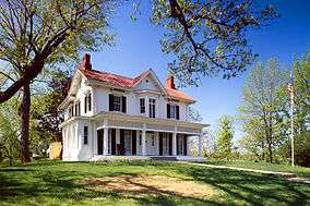
| 7 |
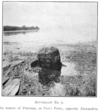
Frederick Douglass National Historic Site |
|
000000001966-10-15-0000October 15, 1966
(#66000033) |
1411 W St., SE.
38°51′45″N 76°59′04″W / 38.8625°N 76.984444°W / 38.8625; -76.984444 (Frederick Douglass National Historic Site) |
SE |
|
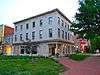
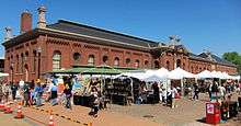
| 8 |
Eastern Market |
|
000000001971-05-27-0000May 27, 1971
(#71000998) |
7th and C Sts., SE.
38°53′11″N 76°59′48″W / 38.886389°N 76.996667°W / 38.886389; -76.996667 (Eastern Market) |
SE |
Badly damaged by an early-morning fire on April 30, 2007; reopened on June 26, 2009
|
| 9 |
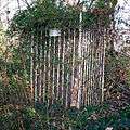
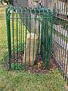
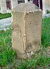
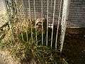
East Corner Boundary Marker of the Original District of Columbia |
|
000000001996-11-01-0000November 1, 1996
(#96001249) |
100 ft. E of jct. of Eastern and Southern Aves.
38°53′35″N 76°54′34″W / 38.893056°N 76.909444°W / 38.893056; -76.909444 (East Corner Boundary Marker of the Original District of Columbia) |
NE and SE |
See List of Boundary Markers of the Original District of Columbia
|
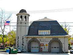
| 10 |
Engine Company No. 19 |
|
000000002010-05-10-0000May 10, 2010
(#10000238) |
2813 Pennsylvania Ave., SE
38°52′24″N 76°58′01″W / 38.873333°N 76.966944°W / 38.873333; -76.966944 (Engine Company No. 19) |
SE |
|
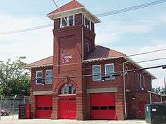
| 11 |
Engine Company No. 25 |
|
000000002007-06-27-0000June 27, 2007
(#07000593) |
3203 Martin Luther King Jr., Ave SE
38°50′35″N 77°00′03″W / 38.843056°N 77.000833°W / 38.843056; -77.000833 (Engine Company No. 25) |
SE |
|
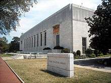
| 12 |
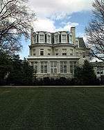
Folger Shakespeare Library |
|
000000001969-06-23-0000June 23, 1969
(#69000294) |
201 E. Capitol St., SE.
38°53′22″N 77°00′11″W / 38.889444°N 77.003056°W / 38.889444; -77.003056 (Folger Shakespeare Library) |
SE |
|
| 13 |
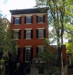
Friendship House – The Maples |
|
000000001973-01-18-0000January 18, 1973
(#73002086) |
619 D St., SE., or 630 South Carolina Ave., SE.
38°53′02″N 76°59′53″W / 38.883889°N 76.998056°W / 38.883889; -76.998056 (Friendship House – The Maples) |
SE |
|
| 14 |
The Furies Collective |
|
000000002016-05-02-0000May 2, 2016
(#16000211) |
219 11th St., SE
38°53′13″N 76°59′29″W / 38.887024°N 76.991494°W / 38.887024; -76.991494 (The Furies Collective) |
SE |
|
| 15 |
Gallinger Municipal Hospital Psychopathic Ward |
|
000000001989-02-27-0000February 27, 1989
(#89000074) |
Reservation 13, 19th St. and Massachusetts Ave., SE
38°53′04″N 76°58′37″W / 38.884444°N 76.976944°W / 38.884444; -76.976944 (Gallinger Municipal Hospital Psychopathic Ward) |
SE |
|
| 16 |
Main Gate, Washington Navy Yard |
|
000000001973-08-14-0000August 14, 1973
(#73002098) |
8th and M Sts., SE.
38°52′35″N 76°59′43″W / 38.876389°N 76.995278°W / 38.876389; -76.995278 (Main Gate, Washington Navy Yard) |
SE |
More commonly known as the Latrobe Gate.
|
| 17 |
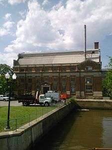
Main Sewerage Pumping Station, District of Columbia |
|
000000002012-05-24-0000May 24, 2012
(#12000297) |
125 O Street, SE
38°52′26″N 77°00′12″W / 38.873828°N 77.003426°W / 38.873828; -77.003426 (Main Sewerage Pumping Station, District of Columbia) |
SE |
|
| 18 |
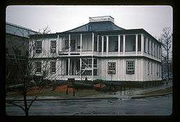
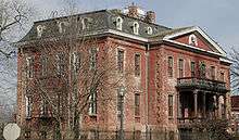
Old Naval Hospital |
|
000000001974-05-03-0000May 3, 1974
(#74002171) |
921 Pennsylvania Ave., SE.
38°52′58″N 76°59′36″W / 38.882778°N 76.993333°W / 38.882778; -76.993333 (Old Naval Hospital) |
SE |
|
| 19 |
Quarters A, Washington Navy Yard |
|
000000001973-08-14-0000August 14, 1973
(#73002111) |
E of Main Gate and S of M St., SE., in the Navy Yard
38°52′34″N 76°59′41″W / 38.876111°N 76.994722°W / 38.876111; -76.994722 (Quarters A, Washington Navy Yard) |
SE |
|
| 20 |
Quarters B, Washington Navy Yard |
|
000000001973-08-14-0000August 14, 1973
(#73002112) |
Charles Morris Ave., SE.
38°52′32″N 76°59′39″W / 38.875556°N 76.994167°W / 38.875556; -76.994167 (Quarters B, Washington Navy Yard) |
SE |
|
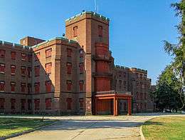
| 21 |
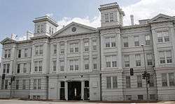
St. Elizabeths Hospital |
|
000000001979-04-26-0000April 26, 1979
(#79003101) |
1100 Alabama Avenue SE.[4]
38°51′01″N 76°59′40″W / 38.850278°N 76.994444°W / 38.850278; -76.994444 (St. Elizabeths Hospital) |
SE |
|
| 22 |
St. Mark's Church |
|
000000001973-05-08-0000May 8, 1973
(#73002117) |
3rd and A Sts., SE.
38°53′18″N 77°00′06″W / 38.888333°N 77.001667°W / 38.888333; -77.001667 (St. Mark's Church) |
SE |
|
| 23 |
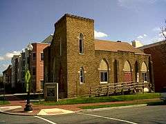
Saint Paul African Union Methodist Church |
|
000000002011-07-28-0000July 28, 2011
(#11000481) |
401 I St., SE.
38°52′45″N 77°00′02″W / 38.879167°N 77.000556°W / 38.879167; -77.000556 (Saint Paul African Union Methodist Church) |
SE |
|
| 24 |
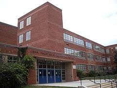
John Philip Sousa Junior High School |
|
000000002001-08-07-0000August 7, 2001
(#01001045) |
3650 Ely Place, SE
38°53′01″N 76°57′08″W / 38.883497°N 76.952217°W / 38.883497; -76.952217 (John Philip Sousa Junior High School) |
SE |
In 1950, eleven African American students were denied admission to the newly constructed all-white Sousa school. This action was eventually overturned in the landmark 1954 Supreme Court decision in Bolling v. Sharpe, which made segregated public schools illegal in the District of Columbia. This defeat of the principle of "separate but equal" was a significant landmark in the modern Civil Rights Movement.
|
| 25 |
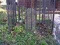
Southeast No. 1 Boundary Marker of the Original District of Columbia |
|
000000001996-11-01-0000November 1, 1996
(#96001248) |
30 ft. south of the junction of Southern Ave. and D St., SE
38°52′58″N 76°55′20″W / 38.882786°N 76.922303°W / 38.882786; -76.922303 (Southeast No. 1 Boundary Marker of the Original District of Columbia) |
SE |
|
| 26 |
Southeast No. 2 Boundary Marker of the Original District of Columbia |
|
000000001996-11-01-0000November 1, 1996
(#96001247) |
4345 Southern Ave.
38°52′20″N 76°56′09″W / 38.872222°N 76.935833°W / 38.872222; -76.935833 (Southeast No. 2 Boundary Marker of the Original District of Columbia) |
SE |
|
| 27 |
Southeast No. 3 Boundary Marker of the Original District of Columbia |
|
000000001996-11-01-0000November 1, 1996
(#96001246) |
3908 Southern Ave.
38°51′43″N 76°56′55″W / 38.861944°N 76.948611°W / 38.861944; -76.948611 (Southeast No. 3 Boundary Marker of the Original District of Columbia) |
SE |
|
| 28 |
Southeast No. 5 Boundary Marker of the Original District of Columbia |
|
000000001996-11-01-0000November 1, 1996
(#96001245) |
280 ft. NE of jct. of Southern Ave. and Valley Terrace
38°50′31″N 76°58′29″W / 38.841944°N 76.974722°W / 38.841944; -76.974722 (Southeast No. 5 Boundary Marker of the Original District of Columbia) |
SE |
|
| 29 |
Southeast No. 6 Boundary Marker of the Original District of Columbia |
|
000000001996-11-01-0000November 1, 1996
(#96001244) |
901 Southern Ave.
38°49′54″N 76°59′17″W / 38.831667°N 76.988056°W / 38.831667; -76.988056 (Southeast No. 6 Boundary Marker of the Original District of Columbia) |
SE |
|
| 30 |
Southeast No. 7 Boundary Marker of the Original District of Columbia |
|
000000001996-11-01-0000November 1, 1996
(#96001243) |
25 ft. NE of jct. of Southern Ave. and Indian Head Rd.
38°49′17″N 77°00′05″W / 38.821389°N 77.001389°W / 38.821389; -77.001389 (Southeast No. 7 Boundary Marker of the Original District of Columbia) |
SE |
|
| 31 |
Southeast No. 9 Boundary Marker of the Original District of Columbia |
|
000000001996-11-01-0000November 1, 1996
(#96001242) |
.225 mi. S of Oxon Cove Br. and 420 ft. E of Shepherd Pkwy.
38°48′14″N 77°01′27″W / 38.803889°N 77.024167°W / 38.803889; -77.024167 (Southeast No. 9 Boundary Marker of the Original District of Columbia) |
SE |
|
| 32 |
U.S. Marine Corps Barracks and Commandant's House |
|
000000001972-12-27-0000December 27, 1972
(#72001435) |
8th and I Sts., SE
38°52′48″N 76°59′41″W / 38.88°N 76.994722°W / 38.88; -76.994722 (U.S. Marine Corps Barracks and Commandant's House) |
SE |
|
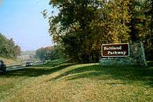
| 33 |
Suitland Parkway |
|
000000001995-06-02-0000June 2, 1995
(#95000604) |
From the Anacostia R. in the District of Columbia to Pennsylvania Ave. in Prince George's County, Maryland
38°50′29″N 76°55′17″W / 38.841389°N 76.921389°W / 38.841389; -76.921389 (Suitland Parkway) |
SE |
|
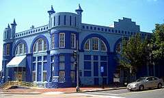
| 34 |
Washington and Georgetown Railroad Car House |
|
000000002006-11-14-0000November 14, 2006
(#06000516) |
770 M St. SE
38°52′44″N 76°59′45″W / 38.878889°N 76.995833°W / 38.878889; -76.995833 (Washington and Georgetown Railroad Car House) |
SE |
Commonly known as the Blue Castle
|
| 35 |
Washington Navy Yard |
|
000000001973-06-19-0000June 19, 1973
(#73002124) |
8th and M Sts., SE
38°52′25″N 76°59′47″W / 38.873611°N 76.996389°W / 38.873611; -76.996389 (Washington Navy Yard) |
SE |
|
| 36 |
Watterston House |
|
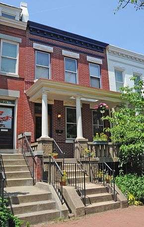
000000001992-01-17-0000January 17, 1992
(#91001942) |
224 2nd St., SE.
38°53′11″N 77°00′13″W / 38.886389°N 77.003611°W / 38.886389; -77.003611 (Watterston House) |
SE |
|
| 37 |
Woodlawn Cemetery |
|
000000001996-12-20-0000December 20, 1996
(#96001499) |
4611 Benning Rd., SE
38°53′06″N 76°56′19″W / 38.885°N 76.938611°W / 38.885; -76.938611 (Woodlawn Cemetery) |
SE |
|