National Register of Historic Places listings in Santa Rosa County, Florida
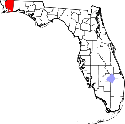
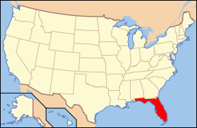
Location of Santa Rosa County in Florida
This is a list of the National Register of Historic Places listings in Santa Rosa County, Florida.
This is intended to be a complete list of the properties and districts on the National Register of Historic Places in Santa Rosa County, Florida, United States. The locations of National Register properties and districts for which the latitude and longitude coordinates are included below, may be seen in a map.[1]
There are 16 properties and districts listed on the National Register in the county.
- This National Park Service list is complete through NPS recent listings posted December 16, 2016.[2]
| Alachua - Baker - Bay - Bradford - Brevard - Broward - Calhoun - Charlotte - Citrus - Clay - Collier - Columbia - DeSoto - Dixie - Duval - Escambia - Flagler - Franklin - Gadsden - Gilchrist - Glades - Gulf - Hamilton - Hardee - Hendry - Hernando - Highlands - Hillsborough - Holmes - Indian River - Jackson - Jefferson - Lafayette - Lake - Lee - Leon - Levy - Liberty - Madison - Manatee - Marion - Martin - Miami-Dade (Miami) - Monroe - Nassau - Okaloosa - Okeechobee - Orange - Osceola - Palm Beach - Pasco - Pinellas - Polk - Putnam - St. Johns - St. Lucie - Santa Rosa - Sarasota - Seminole - Sumter - Suwannee - Taylor - Union - Volusia - Wakulla - Walton - Washington |
Current listings
| [3] | Name on the Register[4] | Image | Date listed[5] | Location | City or town | Description |
|---|---|---|---|---|---|---|
| 1 | Arcadia Sawmill and Arcadia Cotton Mill |  |
(#87001300) |
Address Restricted 30°36′35″N 87°05′03″W / 30.609722°N 87.084167°W |
Milton | |
| 2 | Bagdad Village Historic District | 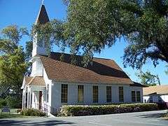 |
(#87001991) |
Roughly bounded by Main, Water, and Oak Streets, Cobb and Woodville Roads, and Cemetery, Pooley, and School Streets 30°36′01″N 87°02′04″W / 30.600278°N 87.034444°W |
Bagdad | |
| 3 | Bethune Blackwater Schooner |  |
(#91000948) |
Address Restricted |
Milton | |
| 4 | Big Heart West | |
(#98001167) |
Address Restricted |
Gulf Breeze | Part of the Archeological Properties of the Naval Live Oaks Reservation MPS |
| 5 | Butcherpen Mound | |
(#98001165) |
Address Restricted |
Gulf Breeze | Part of the Archeological Properties of the Naval Live Oaks Reservation MPS |
| 6 | First American Road in Florida | 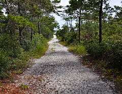 |
(#98001168) |
Gulf Islands National Seashore-Naval Live Oaks Area 30°22′09″N 87°08′21″W / 30.369167°N 87.139167°W |
Gulf Breeze | Part of the Archeological Properties of the Naval Live Oaks Reservation MPS |
| 7 | Florida State Road No. 1 | 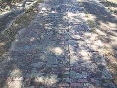 |
(#94000626) |
Roughly, three sections east of Milton, parallel to U.S. Route 90, between Marquis Bayou and Harold 30°37′54″N 86°59′28″W / 30.631667°N 86.991111°W |
Milton | |
| 8 | Louisville and Nashville Depot | 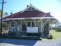 |
(#82001041) |
206 Henry Street 30°37′14″N 87°02′02″W / 30.620556°N 87.033889°W |
Milton | |
| 9 | Milton Historic District | 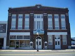 |
(#87001944) |
U.S. Route 90 at the Blackwater River, bounded by Berryhill, Willing, Hill, Canal, Margaret, and Susan Streets 30°37′16″N 87°02′20″W / 30.621111°N 87.038889°W |
Milton | |
| 10 | Mt. Pilgrim African Baptist Church | 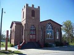 |
(#92000634) |
Junction of Alice and Clara Streets 30°37′11″N 87°02′26″W / 30.619722°N 87.040556°W |
Milton | |
| 11 | Naval Live Oaks Cemetery | |
(#98001166) |
Address Restricted |
Gulf Breeze | Part of the Archeological Properties of the Naval Live Oaks Reservation MPS |
| 12 | Naval Live Oaks Reservation | 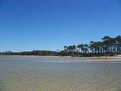 |
(#98001169) |
Gulf Islands National Seashore-Naval Live Oaks Area 30°22′04″N 87°08′24″W / 30.367778°N 87.14°W |
Gulf Breeze | Part of the Archeological Properties of the Naval Live Oaks Reservation MPS |
| 13 | Ollinger-Cobb House | 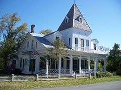 |
(#83001440) |
302 Pine Street 30°37′09″N 87°02′16″W / 30.619167°N 87.037778°W |
Milton | |
| 14 | St. Mary's Episcopal Church and Rectory | 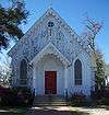 |
(#82002380) |
300-301 Oak Street 30°37′16″N 87°02′10″W / 30.621111°N 87.036111°W |
Milton | |
| 15 | Third Gulf Breeze | |
(#98001164) |
Address Restricted |
Gulf Breeze | Part of the Archeological Properties of the Naval Live Oaks Reservation MPS |
| 16 | Thomas Creek Archeological District | |
(#85003482) |
Address Restricted |
Chumuckla |
See also
| Wikimedia Commons has media related to National Register of Historic Places in Santa Rosa County, Florida. |
- List of National Historic Landmarks in Florida
- National Register of Historic Places listings in Florida
References
- ↑ The latitude and longitude information provided in this table was derived originally from the National Register Information System, which has been found to be fairly accurate for about 99% of listings. For about 1% of NRIS original coordinates, experience has shown that one or both coordinates are typos or otherwise extremely far off; some corrections may have been made. A more subtle problem causes many locations to be off by up to 150 yards, depending on location in the country: most NRIS coordinates were derived from tracing out latitude and longitudes off of USGS topographical quadrant maps created under the North American Datum of 1927, which differs from the current, highly accurate WGS84 GPS system used by most on-line maps. Chicago is about right, but NRIS longitudes in Washington are higher by about 4.5 seconds, and are lower by about 2.0 seconds in Maine. Latitudes differ by about 1.0 second in Florida. Some locations in this table may have been corrected to current GPS standards.
- ↑ "National Register of Historic Places: Weekly List Actions". National Park Service, United States Department of the Interior. Retrieved on December 16, 2016.
- ↑ Numbers represent an ordering by significant words. Various colorings, defined here, differentiate National Historic Landmarks and historic districts from other NRHP buildings, structures, sites or objects.
- ↑ National Park Service (2009-03-13). "National Register Information System". National Register of Historic Places. National Park Service.
- ↑ The eight-digit number below each date is the number assigned to each location in the National Register Information System database, which can be viewed by clicking the number.

Municipalities and communities of Santa Rosa County, Florida, United States | ||
|---|---|---|
| Cities | | |
| Town | ||
| CDPs |
| |
| Unincorporated communities |
| |
This article is issued from Wikipedia - version of the 3/4/2016. The text is available under the Creative Commons Attribution/Share Alike but additional terms may apply for the media files.