| [3] |
Name on the Register[4] |
Image |
Date listed[5] |
Location |
Description |
|---|
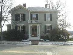
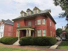
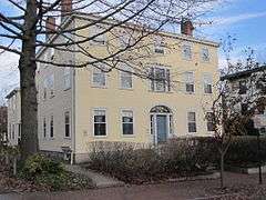
| 1 |
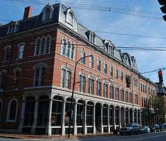
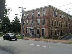
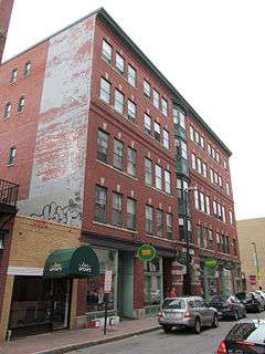
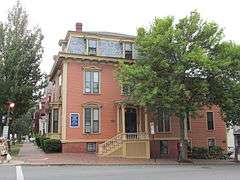
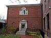
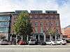
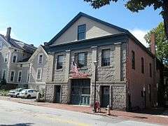
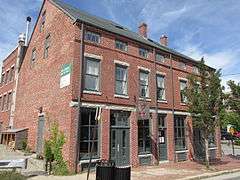
Abyssinian Meeting House |
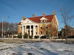
|
000000002006-02-03-0000February 3, 2006
(#05001612) |
73-75 Newbury St.
43°39′44″N 70°14′58″W / 43.662222°N 70.249444°W / 43.662222; -70.249444 (Abyssinian Meeting House) |
|
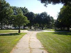
| 2 |
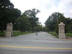
Back Cove |
|
000000001989-10-16-0000October 16, 1989
(#89001706) |
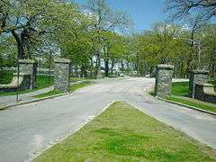
Roughly Baxter Boulevard along Back Cove from Baxter to Veranda Sts.
43°40′25″N 70°16′15″W / 43.673611°N 70.270833°W / 43.673611; -70.270833 (Back Cove) |
|
| 3 |
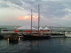
BAGHEERA (schooner) |
|
000000002009-11-04-0000November 4, 2009
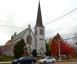
(#09000878) |
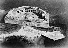
Maine State Pier, Commercial St.
43°39′24″N 70°14′52″W / 43.656606°N 70.247739°W / 43.656606; -70.247739 (BAGHEERA (schooner)) |
|
| 4 |
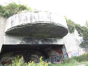
Battery Steele |
|
000000002005-10-20-0000October 20, 2005
(#05001176) |
Florida Ave. on Peaks Island
43°39′32″N 70°10′50″W / 43.658889°N 70.180556°W / 43.658889; -70.180556 (Battery Steele) |
|
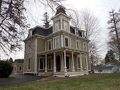
| 5 |
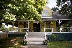
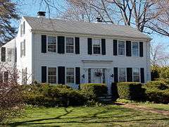
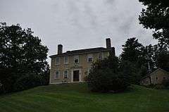
Harrison B. Brown House |
|
000000001980-06-23-0000June 23, 1980
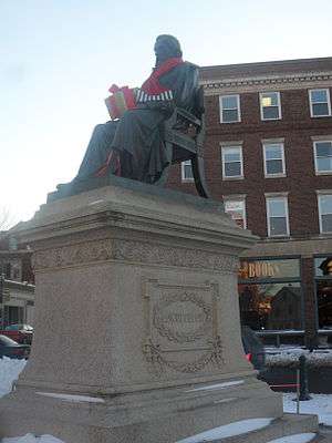
(#80000227) |
400 Danforth St.
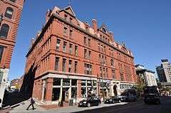
43°38′39″N 70°16′19″W / 43.644167°N 70.271944°W / 43.644167; -70.271944 (Harrison B. Brown House) |
|
| 6 |
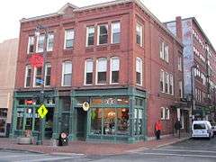
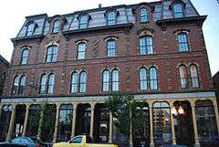
J.B. Brown Memorial Block |
|
000000001978-05-23-0000May 23, 1978
(#78000167) |
Congress and Casco Sts.
43°39′21″N 70°15′42″W / 43.655833°N 70.261667°W / 43.655833; -70.261667 (J.B. Brown Memorial Block) |
|
| 7 |
A.B. Butler House |
|
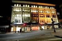
000000001974-05-08-0000May 8, 1974
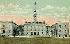
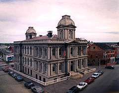
(#74000158) |
4 Walker St.
43°39′09″N 70°16′10″W / 43.6526°N 70.2695°W / 43.6526; -70.2695 (A.B. Butler House) |
|
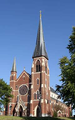
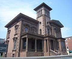
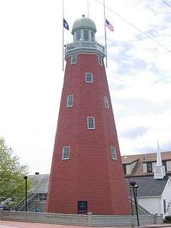
| 8 |
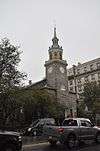
Cathedral of the Immaculate Conception |
|
000000001985-06-20-0000June 20, 1985
(#85001257) |
Cumberland Ave. and Congress St.
43°39′41″N 70°15′17″W / 43.661389°N 70.254722°W / 43.661389; -70.254722 (Cathedral of the Immaculate Conception) |
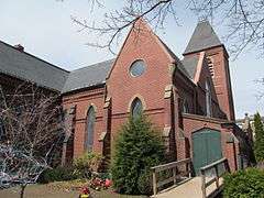
|
| 9 |
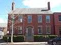
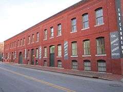
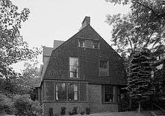
Leonard Bond Chapman House |
|
000000001980-04-23-0000April 23, 1980
(#80000228) |
90 Capisic St.
43°39′43″N 70°18′10″W / 43.661944°N 70.302778°W / 43.661944; -70.302778 (Leonard Bond Chapman House) |
|
| 10 |
Chestnut Street Methodist Church |
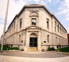
|
000000001977-10-20-0000October 20, 1977
(#77000063) |
11-19 Chestnut St.
43°39′34″N 70°15′30″W / 43.659444°N 70.258333°W / 43.659444; -70.258333 (Chestnut Street Methodist Church) |
|
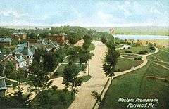
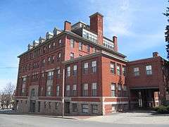
| 11 |
Children's Hospital |
|
000000002012-03-07-0000March 7, 2012
(#12000065) |
68 High St.
43°39′08″N 70°15′38″W / 43.652206°N 70.260441°W / 43.652206; -70.260441 (Children's Hospital) |
|
| 12 |
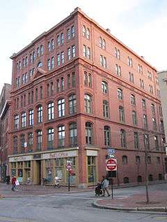
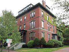
Charles Q. Clapp Block |
|
000000001978-01-31-0000January 31, 1978
(#78000168) |
Congress Sq.
43°39′15″N 70°15′47″W / 43.654167°N 70.263056°W / 43.654167; -70.263056 (Charles Q. Clapp Block) |
|
| 13 |
Charles Q. Clapp House |
|
000000001972-02-23-0000February 23, 1972
(#72000072) |
97 Spring St.
43°39′13″N 70°15′43″W / 43.653611°N 70.261944°W / 43.653611; -70.261944 (Charles Q. Clapp House) |
|
| 14 |
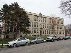
Nathan Clifford School |
|
000000002013-12-18-0000December 18, 2013
(#13000925) |
180 Falmouth St.
43°39′37″N 70°16′49″W / 43.660281°N 70.280317°W / 43.660281; -70.280317 (Nathan Clifford School) |
|
| 15 |
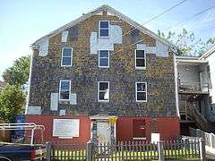
Deering Estate Barn |
Upload image |
000000001969-08-13-0000August 13, 1969
(#09000089) |
Falmouth St. on the University of Southern Maine campus
43°39′49″N 70°16′40″W / 43.663611°N 70.277778°W / 43.663611; -70.277778 (Deering Estate Barn) |
Demolished c. 1970.[6]
|
| 16 |
Deering Oaks |
|
000000001989-10-16-0000October 16, 1989
(#89001708) |
Roughly bounded by Interstate 295, Forest St., Park Ave., and Deering Ave.
43°39′32″N 70°16′20″W / 43.658889°N 70.272222°W / 43.658889; -70.272222 (Deering Oaks) |
|
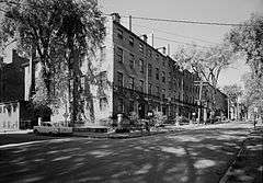
| 17 |
Deering Street Historic District |
|
000000001983-01-27-0000January 27, 1983
(#83000448) |
Congress, Deering, Mellen, and State Sts.
43°39′17″N 70°16′07″W / 43.654722°N 70.268611°W / 43.654722; -70.268611 (Deering Street Historic District) |
|
| 18 |
Gen. Neal Dow House |
|
000000001973-04-11-0000April 11, 1973
(#73000236) |
714 Congress St.
43°39′11″N 70°16′12″W / 43.653056°N 70.27°W / 43.653056; -70.27 (Gen. Neal Dow House) |
|
| 19 |
Nathaniel Dyer House |
|
000000001987-04-15-0000April 15, 1987
(#86003534) |
168 York St.
43°38′58″N 70°15′34″W / 43.6495°N 70.2594°W / 43.6495; -70.2594 (Nathaniel Dyer House) |
|
| 20 |
Eastern Cemetery |
|
000000001973-12-12-0000December 12, 1973
(#73000112) |
Congress St. at its junction with Mountfort St.
43°39′46″N 70°15′03″W / 43.662778°N 70.250833°W / 43.662778; -70.250833 (Eastern Cemetery) |
|
| 21 |
Eastern Promenade |
|
000000001989-10-16-0000October 16, 1989
(#89001707) |
Roughly bounded by Eastern Promenade and Casco Bay
43°40′20″N 70°14′50″W / 43.672222°N 70.247222°W / 43.672222; -70.247222 (Eastern Promenade) |
|
| 22 |
Eighth Maine Regiment Memorial |
Upload image |
000000002006-10-04-0000October 4, 2006
(#06000919) |
13 8th Main Ave., Peaks Island
43°39′09″N 70°11′32″W / 43.6525°N 70.192222°W / 43.6525; -70.192222 (Eighth Maine Regiment Memorial) |
|
| 23 |
Engine Company Number Nine Firehouse |
|
000000002010-10-28-0000October 28, 2010
(#10000876) |
17 Arbor St.
43°41′08″N 70°17′34″W / 43.685556°N 70.292778°W / 43.685556; -70.292778 (Engine Company Number Nine Firehouse) |
|
| 24 |
Everett Chambers |
|
000000002006-05-19-0000May 19, 2006
(#06000397) |
47-55 Oak St.
43°39′18″N 70°15′42″W / 43.655°N 70.261667°W / 43.655; -70.261667 (Everett Chambers) |
|
| 25 |
Evergreen Cemetery |
|
000000001992-06-18-0000June 18, 1992
(#92000791) |
Off the western side of Stevens Ave., north of its junction with Brighton Ave.
43°40′51″N 70°18′04″W / 43.680833°N 70.301111°W / 43.680833; -70.301111 (Evergreen Cemetery) |
|
| 26 |
Fifth Maine Regiment Community Center |
|
000000001978-01-05-0000January 5, 1978
(#78000169) |
Seashore Ave. on Peaks Island
43°39′10″N 70°11′36″W / 43.652778°N 70.193333°W / 43.652778; -70.193333 (Fifth Maine Regiment Community Center) |
|
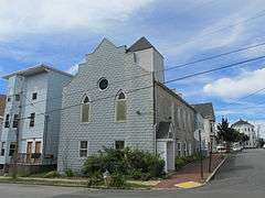
| 27 |
First Parish Church |
|
000000001973-01-12-0000January 12, 1973
(#73000113) |
425 Congress St.
43°39′30″N 70°15′32″W / 43.658333°N 70.258889°W / 43.658333; -70.258889 (First Parish Church) |
|
| 28 |
Fort Gorges |
|
000000001973-08-28-0000August 28, 1973
(#73000114) |
East of Portland on Hog Island in Portland Harbor
43°39′46″N 70°13′18″W / 43.662778°N 70.221667°W / 43.662778; -70.221667 (Fort Gorges) |
|
| 29 |
Fort McKinley Historic District |
Upload image |
000000001985-03-21-0000March 21, 1985
(#85000611) |
Great Diamond Island
43°41′00″N 70°11′47″W / 43.683333°N 70.196389°W / 43.683333; -70.196389 (Fort McKinley Historic District) |
|
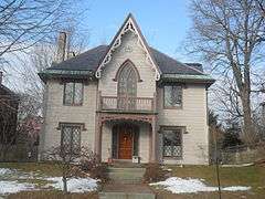
| 30 |
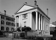
The Gothic House |
|
000000001974-12-31-0000December 31, 1974
(#72001539) |
387 Spring St.
43°38′45″N 70°16′30″W / 43.645833°N 70.275°W / 43.645833; -70.275 (The Gothic House) |
|
| 31 |
Green Memorial A.M.E. Zion Church |
|
000000001973-01-17-0000January 17, 1973
(#73000115) |
46 Sheridan St.
43°39′50″N 70°14′58″W / 43.663889°N 70.249444°W / 43.663889; -70.249444 (Green Memorial A.M.E. Zion Church) |
|
| 32 |
Byron Greenough Block |
|
000000001977-03-10-0000March 10, 1977
(#77000065) |
Free and Middle Sts.
43°39′25″N 70°15′28″W / 43.656944°N 70.257778°W / 43.656944; -70.257778 (Byron Greenough Block) |
|
| 33 |
Griffin House |
|
000000001984-07-19-0000July 19, 1984
(#84001360) |
200 High St.
43°39′21″N 70°15′59″W / 43.655833°N 70.266389°W / 43.655833; -70.266389 (Griffin House) |
|
| 34 |
Hamblen Block |
|
000000001983-07-21-0000July 21, 1983
(#83000449) |
188-194 Danforth St.
43°38′54″N 70°15′50″W / 43.648333°N 70.263889°W / 43.648333; -70.263889 (Hamblen Block) |
|
| 35 |
Hamblen Development Historic District |
|
000000001992-06-18-0000June 18, 1992
(#92000802) |
188-208 Danforth St.
43°38′54″N 70°15′50″W / 43.648333°N 70.263889°W / 43.648333; -70.263889 (Hamblen Development Historic District) |
|
| 36 |
Asa Hanson Block |
|
000000002001-12-31-0000December 31, 2001
(#01001418) |
548-550 Congress St.
43°39′19″N 70°15′43″W / 43.655278°N 70.261944°W / 43.655278; -70.261944 (Asa Hanson Block) |
|
| 37 |
How Houses |
|
000000001980-01-20-0000January 20, 1980
(#80000377) |
23 Danforth St., 30-32, 40 Pleasant Sts.
43°39′14″N 70°15′30″W / 43.653889°N 70.258333°W / 43.653889; -70.258333 (How Houses) |
A small group of houses belonging to the How family
|
| 38 |
Daniel How House |
|
000000001973-04-24-0000April 24, 1973
(#73000265) |
23 Danforth St.
43°39′14″N 70°15′30″W / 43.653889°N 70.258333°W / 43.653889; -70.258333 (Daniel How House) |
|
| 39 |
Joseph Holt Ingraham House |
|
000000001973-07-16-0000July 16, 1973
(#73000116) |
51 State St.
43°39′00″N 70°15′41″W / 43.65°N 70.261389°W / 43.65; -70.261389 (Joseph Holt Ingraham House) |
|
| 40 |
Lancaster Block |
|
000000001982-09-29-0000September 29, 1982
(#82000745) |
474 Congress St.
43°39′25″N 70°15′35″W / 43.656944°N 70.259722°W / 43.656944; -70.259722 (Lancaster Block) |
|
| 41 |
Adam P. Leighton House |
|
000000001982-09-29-0000September 29, 1982
(#82000746) |
261 Western Promenade
43°39′04″N 70°16′34″W / 43.651111°N 70.276111°W / 43.651111; -70.276111 (Adam P. Leighton House) |
|
| 42 |
Lincoln Park |
|
000000001989-10-16-0000October 16, 1989
(#89001709) |
Bounded by Pearl, Franklin, Market, and Federal Sts.
43°39′35″N 70°15′18″W / 43.659722°N 70.255°W / 43.659722; -70.255 (Lincoln Park) |
|
| 43 |
Henry Wadsworth Longfellow Monument |
|
000000001990-04-05-0000April 5, 1990
(#90000580) |
Southeastern corner of State and Congress Sts.
43°39′11″N 70°16′02″W / 43.653056°N 70.267222°W / 43.653056; -70.267222 (Henry Wadsworth Longfellow Monument) |
|
| 44 |
Maine Archeological Site No. 9-16 |
Upload image |
000000001979-05-07-0000May 7, 1979
(#79000141) |
Great Diamond Island[7]
|
Native American site
|
| 45 |
Maine Central Railroad General Office Building |
|
000000001988-01-07-0000January 7, 1988
(#87002192) |
222-224 St. John St.
43°39′03″N 70°16′48″W / 43.650833°N 70.28°W / 43.650833; -70.28 (Maine Central Railroad General Office Building) |
|
| 46 |
Maine Eye and Ear Infirmary |
|
000000001986-09-25-0000September 25, 1986
(#86002469) |
794-800 Congress St.
43°39′13″N 70°16′24″W / 43.653611°N 70.273333°W / 43.653611; -70.273333 (Maine Eye and Ear Infirmary) |
|
| 47 |
Maine Historical Society |
|
000000001980-11-17-0000November 17, 1980
(#80000230) |
485 Congress St.
43°39′25″N 70°15′38″W / 43.656944°N 70.260556°W / 43.656944; -70.260556 (Maine Historical Society) |
The Society's 1907 Library Building, located next to the Wadsworth-Longfellow House.
|
| 48 |
Maine Publicity Bureau Building |
|
000000001990-01-26-0000January 26, 1990
(#89002344) |
501 Danforth St.
43°38′38″N 70°16′34″W / 43.643895°N 70.276083°W / 43.643895; -70.276083 (Maine Publicity Bureau Building) |
|
| 49 |
Marine Hospital |
|
000000001974-08-21-0000August 21, 1974
(#74000161) |
331 Veranda St.
43°41′18″N 70°14′51″W / 43.688333°N 70.2475°W / 43.688333; -70.2475 (Marine Hospital) |
|
| 50 |
Mariner's Church |
|
000000001973-04-23-0000April 23, 1973
(#73000117) |
368-374 Fore St.
43°39′23″N 70°15′11″W / 43.656389°N 70.253056°W / 43.656389; -70.253056 (Mariner's Church) |
|
| 51 |
Masonic Temple |
|
000000001982-02-11-0000February 11, 1982
(#82000748) |
415 Congress St.
43°39′32″N 70°15′30″W / 43.658889°N 70.258333°W / 43.658889; -70.258333 (Masonic Temple) |
|
| 52 |
McLellan-Sweat Mansion |
|
000000001970-03-05-0000March 5, 1970
(#70000073) |
111 High St.
43°39′12″N 70°15′45″W / 43.653333°N 70.2625°W / 43.653333; -70.2625 (McLellan-Sweat Mansion) |
|
| 53 |
Mechanics' Hall |
|
000000001973-10-03-0000October 3, 1973
(#73000118) |
519 Congress St.
43°39′23″N 70°15′43″W / 43.656389°N 70.261944°W / 43.656389; -70.261944 (Mechanics' Hall) |
|
| 54 |
William Minott House |
|
000000001979-07-10-0000July 10, 1979
(#79000142) |
45 Park St.
43°39′03″N 70°15′38″W / 43.650833°N 70.260556°W / 43.650833; -70.260556 (William Minott House) |
|
| 55 |
Morse-Libby Mansion |
|
000000001970-05-19-0000May 19, 1970
(#70000074) |
109 Danforth St.
43°39′06″N 70°15′40″W / 43.651667°N 70.261111°W / 43.651667; -70.261111 (Morse-Libby Mansion) |
|
| 56 |
North School |
|
000000001982-04-12-0000April 12, 1982
(#82000749) |
248-264 Congress Street
43°39′44″N 70°15′07″W / 43.662222°N 70.251944°W / 43.662222; -70.251944 (North School) |
|
| 57 |
Park Street Row |
|
000000001972-02-23-0000February 23, 1972
(#72000074) |
88-114 Park St.
43°39′06″N 70°15′46″W / 43.651667°N 70.262778°W / 43.651667; -70.262778 (Park Street Row) |
|
| 58 |
Porteous, Mitchell and Braun Company Building |
|
000000001996-09-27-0000September 27, 1996
(#96001039) |
522-528 Congress St.
43°39′21″N 70°15′40″W / 43.655833°N 70.261111°W / 43.655833; -70.261111 (Porteous, Mitchell and Braun Company Building) |
|
| 59 |
Portland City Hall |
|
000000001973-05-07-0000May 7, 1973
(#73000119) |
389 Congress St.
43°39′34″N 70°15′27″W / 43.659444°N 70.2575°W / 43.659444; -70.2575 (Portland City Hall) |
|
| 60 |
Portland City Hospital |
|
000000001985-03-21-0000March 21, 1985
(#85000612) |
Brighton Ave.
43°40′37″N 70°19′31″W / 43.676944°N 70.325278°W / 43.676944; -70.325278 (Portland City Hospital) |
|
| 61 |
Portland Club |
|
000000001973-01-25-0000January 25, 1973
(#73000120) |
156 State St.
43°39′07″N 70°15′58″W / 43.651944°N 70.266111°W / 43.651944; -70.266111 (Portland Club) |
|
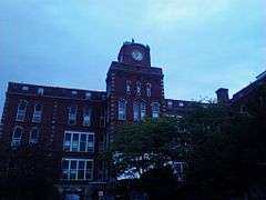
| 62 |
Portland High School |
|
000000001984-11-23-0000November 23, 1984
(#84003879) |
284 Cumberland Ave.
43°39′33″N 70°15′34″W / 43.659167°N 70.259444°W / 43.659167; -70.259444 (Portland High School) |
|
| 63 |
Portland Observatory |
|
000000001973-04-24-0000April 24, 1973
(#73000122) |
138 Congress St.
43°39′56″N 70°14′11″W / 43.665556°N 70.236389°W / 43.665556; -70.236389 (Portland Observatory) |
|
| 64 |
Portland Packing Company Factory |
|
000000001996-06-07-0000June 7, 1996
(#96000651) |
14-26 York St.
43°39′14″N 70°15′27″W / 43.653889°N 70.2575°W / 43.653889; -70.2575 (Portland Packing Company Factory) |
|
| 65 |
Portland Soldiers and Sailors Monument |
|
000000001998-04-01-0000April 1, 1998
(#98000308) |
Junction of Congress St. and Federal St.
43°39′26″N 70°15′34″W / 43.657222°N 70.259444°W / 43.657222; -70.259444 (Portland Soldiers and Sailors Monument) |
|
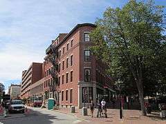
| 66 |
Portland Waterfront |
|
000000001974-05-02-0000May 2, 1974
(#74000353) |
Waterfront area; also 79-85 and 295-309 Commercial and 3 Center Sts.; also Merrill's Wharf, 252-260 Commercial St.
43°39′17″N 70°15′37″W / 43.654722°N 70.260278°W / 43.654722; -70.260278 (Portland Waterfront) |
Addresses on Commercial and Center Sts. represent boundary increases of 000000001984-12-23-0000December 23, 1984 and 000000002012-03-07-0000March 7, 2012
|
| 67 |
Rackleff Building |
|
000000001973-05-09-0000May 9, 1973
(#73000123) |
127, 129, 131, and 133 Middle St.
43°39′31″N 70°15′14″W / 43.658611°N 70.253889°W / 43.658611; -70.253889 (Rackleff Building) |
|
| 68 |
Thomas Brackett Reed House |
|
000000001973-05-07-0000May 7, 1973
(#73000239) |
30-32 Deering St.
43°39′15″N 70°16′03″W / 43.654167°N 70.2675°W / 43.654167; -70.2675 (Thomas Brackett Reed House) |
Home of Thomas Brackett Reed, nineteenth-century Speaker of the United States House of Representatives
|
| 69 |
John B. Russwurm House |
|
000000001983-07-21-0000July 21, 1983
(#83000450) |
238 Ocean Ave.
43°40′44″N 70°16′49″W / 43.678889°N 70.280278°W / 43.678889; -70.280278 (John B. Russwurm House) |
Home of John B. Russwurm, abolitionist
|
| 70 |
St. Lawrence Church |
|
000000001979-10-01-0000October 1, 1979
(#79000145) |
76 Congress St.
43°40′01″N 70°14′48″W / 43.666944°N 70.246667°W / 43.666944; -70.246667 (St. Lawrence Church) |
Church demolished; parish hall converted to a performing arts center.
|
| 71 |
St. Paul's Church and Rectory |
|
000000001978-12-22-0000December 22, 1978
(#78000176) |
279 Congress St.
43°39′43″N 70°15′12″W / 43.661944°N 70.253333°W / 43.661944; -70.253333 (St. Paul's Church and Rectory) |
|
| 72 |
Schlotterbeck and Foss Building |
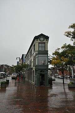
Upload image |
000000002016-07-11-0000July 11, 2016
(#16000436) |
117 Preble St.
43°39′37″N 70°15′47″W / 43.660280°N 70.263176°W / 43.660280; -70.263176 (Schlotterbeck and Foss Building) |
|
| 73 |
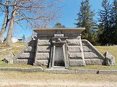
F.O.J. Smith Tomb |
|
000000001974-12-31-0000December 31, 1974
(#74000166) |
Evergreen Cemetery
43°40′47″N 70°18′08″W / 43.679665°N 70.302195°W / 43.679665; -70.302195 (F.O.J. Smith Tomb) |
|
| 74 |
Sparrow House |
|
000000001982-10-29-0000October 29, 1982
(#82000421) |
35 Arlington St.
43°40′12″N 70°16′58″W / 43.67°N 70.282778°W / 43.67; -70.282778 (Sparrow House) |
|
| 75 |
Spring Street Historic District |
|
000000001970-04-03-0000April 3, 1970
(#70000043) |
Roughly bounded by Forest, Oak, Danforth, Brackett and Pine Sts.
43°39′08″N 70°15′50″W / 43.652222°N 70.263889°W / 43.652222; -70.263889 (Spring Street Historic District) |
|
| 76 |
John Calvin Stevens House |
|
000000001973-07-16-0000July 16, 1973
(#73000125) |
52 Bowdoin St.
43°38′48″N 70°16′30″W / 43.646667°N 70.275°W / 43.646667; -70.275 (John Calvin Stevens House) |
|
| 77 |
Stroudwater Historic District |
|
000000001973-02-16-0000February 16, 1973
(#73000126) |
Residential area at the confluence of the Stroudwater and Fore Rivers
43°39′24″N 70°18′52″W / 43.656667°N 70.314444°W / 43.656667; -70.314444 (Stroudwater Historic District) |
|
| 78 |
Tate House |
|
000000001970-01-12-0000January 12, 1970
(#70000072) |
1270 Westbrook St.
43°39′25″N 70°18′43″W / 43.656944°N 70.311944°W / 43.656944; -70.311944 (Tate House) |
|
| 79 |
Thompson Block |
|
000000001973-02-28-0000February 28, 1973
(#73000127) |
117, 119, 121, 123, and 125 Middle St.
43°39′32″N 70°15′11″W / 43.658889°N 70.253056°W / 43.658889; -70.253056 (Thompson Block) |
|
| 80 |
Tracy-Causer Block |
|
000000001994-03-17-0000March 17, 1994
(#89001941) |
505-509 Fore St.
43°39′18″N 70°15′26″W / 43.655°N 70.257222°W / 43.655; -70.257222 (Tracy-Causer Block) |
|
| 81 |
U.S. Courthouse |
|
000000001974-02-12-0000February 12, 1974
(#74000168) |
156 Federal St.
43°39′31″N 70°15′42″W / 43.658611°N 70.261667°W / 43.658611; -70.261667 (U.S. Courthouse) |
|
| 82 |
U.S. Customhouse |
|
000000001973-05-17-0000May 17, 1973
(#73000128) |
312 Fore St.
43°39′26″N 70°15′05″W / 43.657222°N 70.251389°W / 43.657222; -70.251389 (U.S. Customhouse) |
|
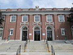
| 83 |
US Post Office-Portland Main |
|
000000001986-05-09-0000May 9, 1986
(#86001011) |
125 Forest Ave.
43°39′30″N 70°16′00″W / 43.658333°N 70.266667°W / 43.658333; -70.266667 (US Post Office-Portland Main) |
|
| 84 |
Wadsworth-Longfellow House |
|
000000001966-10-15-0000October 15, 1966
(#66000090) |
487 Congress St.
43°39′23″N 70°15′40″W / 43.656389°N 70.261111°W / 43.656389; -70.261111 (Wadsworth-Longfellow House) |
|
| 85 |
Wendameen (Yacht) |
|
000000001992-03-26-0000March 26, 1992
(#92000273) |
Maine State Pier, Commercial St.
43°39′26″N 70°14′55″W / 43.657160°N 70.248559°W / 43.657160; -70.248559 (Wendameen (Yacht)) |
Although listed in Camden, she is now based in Portland.[8]
|
| 86 |
Westbrook College Historic District |
|
000000001977-09-15-0000September 15, 1977
(#77000066) |
716 Stevens Ave.
43°41′00″N 70°17′45″W / 43.683333°N 70.295833°W / 43.683333; -70.295833 (Westbrook College Historic District) |
|
| 87 |
Western Promenade |
|
000000001989-10-16-0000October 16, 1989
(#89001710) |
Roughly Western Promenade from Maine Medical Center to Valley St.
43°38′48″N 70°16′32″W / 43.646667°N 70.275556°W / 43.646667; -70.275556 (Western Promenade) |
|
| 88 |
Western Promenade Historic District |
|
000000001984-02-16-0000February 16, 1984
(#84001363) |
Roughly bounded by Western Promenade and Bramhall, Brackett, Emery, and Danforth Sts.
43°38′54″N 70°16′19″W / 43.648333°N 70.271944°W / 43.648333; -70.271944 (Western Promenade Historic District) |
|
| 89 |
Williston-West Church and Parish House |
|
000000001980-06-22-0000June 22, 1980
(#80000232) |
32 Thomas St.
43°38′52″N 70°16′16″W / 43.647778°N 70.271111°W / 43.647778; -70.271111 (Williston-West Church and Parish House) |
|
| 90 |
Woodman Building |
|
000000001972-02-23-0000February 23, 1972
(#72000075) |
133-141 Middle St.
43°39′31″N 70°15′15″W / 43.658611°N 70.254167°W / 43.658611; -70.254167 (Woodman Building) |
|


.jpg)
.jpg)