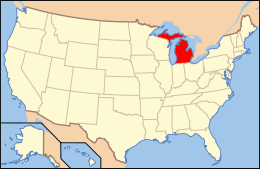
National Register of Historic Places listings in Ottawa County, Michigan
The following is a list of Registered Historic Places in Ottawa County, Michigan.
- This National Park Service list is complete through NPS recent listings posted December 16, 2016.[1]
| [2] | Name on the Register[3] | Image | Date listed[4] | Location | City or town | Description |
|---|---|---|---|---|---|---|
| 1 | Battle Point Site | 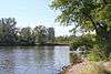 |
(#73000956) |
Address Restricted |
Northwestern Ottawa County | |
| 2 | Aloys Bilz House |  |
(#87002139) |
107 S. Division St. 43°04′34″N 86°12′03″W / 43.076111°N 86.200833°W |
Spring Lake | |
| 3 | Isaac Cappon House | 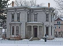 |
(#84001478) |
228 W. 9th St. 42°47′21″N 86°07′04″W / 42.789167°N 86.117778°W |
Holland | |
| 4 | Edward P. Ferry House | 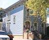 |
(#82002860) |
514 Lafayette St. 43°03′35″N 86°13′38″W / 43.059722°N 86.227222°W |
Grand Haven | |
| 5 | Fruitport Road-Pettys Bayou Bridge | 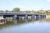 |
(#99001535) |
Fruitport Rd. over Pettys Bayou 43°05′22″N 86°10′31″W / 43.089444°N 86.175278°W |
Spring Lake Township | |
| 6 | Egbert H. Gold Estate |  |
(#84000548) |
1116 Marigold Ln. 42°46′51″N 86°09′21″W / 42.780833°N 86.155833°W |
Holland | |
| 7 | Grand Haven Historic District | Upload image | (#16000584) |
Washington Ave, adjacent Sts Harbor Dr. through 600 blks. 43°03′53″N 86°14′01″W / 43.064734°N 86.233632°W |
Grand Haven | |
| 8 | Grand Rapids, Grand Haven and Muskegon Railway Depot | 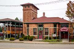 |
(#73002294) |
363 W. Main St. 43°03′51″N 85°56′13″W / 43.064203°N 85.937017°W |
Coopersville | |
| 9 | Grand Trunk Western Railroad Grand Haven Coal Tipple | Upload image | (#16000583) |
300 Block of N. Harbor Dr. in Chinook Pier Park 43°04′05″N 86°13′51″W / 43.068080°N 86.230757°W |
Grand Haven | |
| 10 | Holland Downtown Historic District | 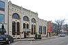 |
(#90001534) |
Roughly Eighth St. from just east of College Ave. to River Ave. and River Ave. from Ninth St. to just north of Eighth St. 42°47′24″N 86°06′26″W / 42.79°N 86.107222°W |
Holland | |
| 11 | Holland Harbor Lighthouse | 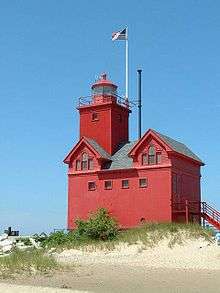 |
(#78001509) |
South Pier, Holland Harbor 42°46′22″N 86°12′44″W / 42.772778°N 86.212222°W |
Holland | |
| 12 | Holland Historic District | 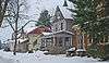 |
(#83000889) |
11th, 12th, 13th Sts., and Washington, Maple, and Pine Aves. 42°47′12″N 86°06′48″W / 42.786667°N 86.113333°W |
Holland | Boundary increase (added 1990-08-10): Roughly bounded by River Ave., Pine Ave., 16th St., 14th St., Columbia Ave., 13th St., Central Ave., and 10th St. |
| 13 | Holland Old City Hall and Fire Station | 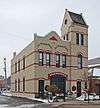 |
(#85000063) |
108 E. 8th St. 42°47′24″N 86°06′08″W / 42.79°N 86.102222°W |
Holland | |
| 14 | Holland Reformed Protestant Dutch Church |  |
(#90001243) |
57 E. 10th St. 42°47′20″N 86°06′17″W / 42.788882°N 86.104833°W |
Holland | Also known as the Pillar Church |
| 15 | Hudsonville Christian School | 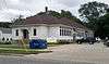 |
(#08000224) |
5692 School Ave. 42°52′20″N 85°51′53″W / 42.872222°N 85.864722°W |
Hudsonville | |
| 16 | Thomas and Anna Morrissey House |  |
(#99000337) |
190 W. 9th St. 42°47′21″N 86°06′58″W / 42.789167°N 86.116111°W |
Holland | |
| 17 | Olive Township District No. 1 School |  |
(#98001061) |
11611 Stanton St. 42°56′11″N 86°04′21″W / 42.936389°N 86.0725°W |
Olive Township | |
| 18 | Ottawa Beach Historic District | Upload image | (#95000451) |
Ottawa Beach Rd., Park Township 42°46′34″N 86°12′22″W / 42.776111°N 86.206111°W |
Ottawa Beach | |
| 19 | Pere Marquette Railway Locomotive #1223 | 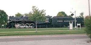 |
(#00001490) |
Chinook Pier Park, Jackson Ave. 43°04′04″N 86°13′48″W / 43.067778°N 86.23°W |
Grand Haven | |
| 20 | Piers and Revetments at Grand Haven, Michigan | 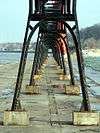 |
(#95001161) |
Mouth of Grand R. 43°03′32″N 86°15′22″W / 43.058889°N 86.256111°W |
Grand Haven | |
| 21 | Nathaniel and Esther (Savidge) Robbins House | 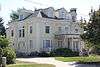 |
(#09000203) |
20 S. 5th Ave. 43°03′45″N 86°13′35″W / 43.062369°N 86.226294°W |
Grand Haven | |
| 22 | Spoonville Site |  |
(#73002158) |
Address Restricted |
Crockery | |
| 23 | Third Reformed Church of Holland | 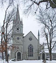 |
(#71000418) |
110 W. 12th St. 42°47′07″N 86°06′45″W / 42.785278°N 86.1125°W |
Holland | |
| 24 | Benjamin Van Raalte House | 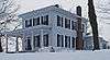 |
(#89000790) |
1076 Sixteenth St. 42°46′53″N 86°03′43″W / 42.781389°N 86.061944°W |
Holland |
See also
| Wikimedia Commons has media related to National Register of Historic Places in Ottawa County, Michigan. |
- List of Registered Historic Places in Michigan
- List of Michigan State Historic Sites in Ottawa County, Michigan
References
- ↑ "National Register of Historic Places: Weekly List Actions". National Park Service, United States Department of the Interior. Retrieved on December 16, 2016.
- ↑ Numbers represent an ordering by significant words. Various colorings, defined here, differentiate National Historic Landmarks and historic districts from other NRHP buildings, structures, sites or objects.
- ↑ National Park Service (2008-04-24). "National Register Information System". National Register of Historic Places. National Park Service.
- ↑ The eight-digit number below each date is the number assigned to each location in the National Register Information System database, which can be viewed by clicking the number.
| Lists by county |
|   |
|---|---|---|
| Other lists |
| |
| Topics | |
|---|---|
| Lists by states |
|
| Lists by insular areas | |
| Lists by associated states | |
| Other areas | |
| |
This article is issued from Wikipedia - version of the 9/20/2016. The text is available under the Creative Commons Attribution/Share Alike but additional terms may apply for the media files.