National Register of Historic Places listings in Osceola County, Florida
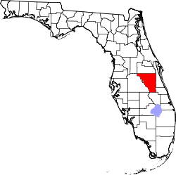
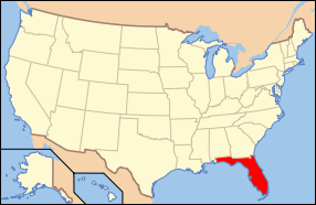
Location of Osceola County in Florida
This is a list of the National Register of Historic Places listings in Osceola County, Florida.
This is intended to be a complete list of the properties and districts on the National Register of Historic Places in Osceola County, Florida, United States. The locations of National Register properties and districts for which the latitude and longitude coordinates are included below, may be seen in a map.[1]
There are 8 properties and districts listed on the National Register in the county.
- This National Park Service list is complete through NPS recent listings posted December 16, 2016.[2]
| Alachua - Baker - Bay - Bradford - Brevard - Broward - Calhoun - Charlotte - Citrus - Clay - Collier - Columbia - DeSoto - Dixie - Duval - Escambia - Flagler - Franklin - Gadsden - Gilchrist - Glades - Gulf - Hamilton - Hardee - Hendry - Hernando - Highlands - Hillsborough - Holmes - Indian River - Jackson - Jefferson - Lafayette - Lake - Lee - Leon - Levy - Liberty - Madison - Manatee - Marion - Martin - Miami-Dade (Miami) - Monroe - Nassau - Okaloosa - Okeechobee - Orange - Osceola - Palm Beach - Pasco - Pinellas - Polk - Putnam - St. Johns - St. Lucie - Santa Rosa - Sarasota - Seminole - Sumter - Suwannee - Taylor - Union - Volusia - Wakulla - Walton - Washington |
Current listings
| [3] | Name on the Register[4] | Image | Date listed[5] | Location | City or town | Description |
|---|---|---|---|---|---|---|
| 1 | Colonial Estate | 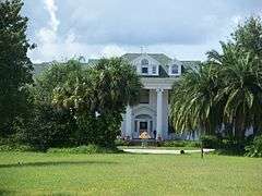 |
(#93001455) |
2450 Old Dixie Highway 28°18′59″N 81°24′13″W / 28.316389°N 81.403611°W |
Kissimmee | NRHP# 93001455, Part of the Kissimmee MPS |
| 2 | Desert Inn |  |
(#93001158) |
5570 South Kenansville Road 27°42′00″N 80°54′18″W / 27.7°N 80.905°W |
Yeehaw Junction | NRHP# 93001158 |
| 3 | First United Methodist Church | 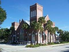 |
(#93001457) |
215 East Church Street 28°17′22″N 81°24′24″W / 28.289444°N 81.406667°W |
Kissimmee | NRHP# 93001457, Part of the Kissimmee MPS |
| 4 | Grand Army of the Republic Memorial Hall | 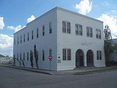 |
(#97000097) |
1101 Massachusetts Avenue 28°14′51″N 81°17′05″W / 28.2475°N 81.284722°W |
St. Cloud | NRHP# 97000097 |
| 5 | Kissimmee Historic District |  |
(#93001454) |
Roughly bounded by Aultman Street, Monument Avenue, Penfield Street, and Randolph Avenue 28°17′31″N 81°24′40″W / 28.291944°N 81.411111°W |
Kissimmee | NRHP# 93001454, Part of the Kissimmee MPS |
| 6 | Monument of States | 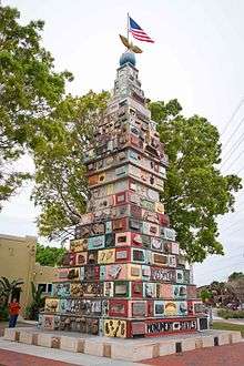 |
(#15000862) |
East Monument Avenue & Lakeview Drive 28°17′30″N 81°24′17″W / 28.291676°N 81.404604°W |
Kissimmee | NRHP #15000862 |
| 7 | Old Holy Redeemer Catholic Church |  |
(#93001456) |
120 North Spoule Avenue 28°17′45″N 81°24′24″W / 28.295833°N 81.406667°W |
Kissimmee | NRHP# 93001456, Part of the Kissimmee MPS |
| 8 | Osceola County Courthouse |  |
(#77000406) |
Bounded by Emmett, Bryan, Rose, and Vernon Streets 28°17′28″N 81°24′42″W / 28.291111°N 81.411667°W |
Kissimmee | NRHP# 77000406 |
See also
| Wikimedia Commons has media related to National Register of Historic Places in Osceola County, Florida. |
- List of National Historic Landmarks in Florida
- National Register of Historic Places listings in Florida
References
- ↑ The latitude and longitude information provided in this table was derived originally from the National Register Information System, which has been found to be fairly accurate for about 99% of listings. For about 1% of NRIS original coordinates, experience has shown that one or both coordinates are typos or otherwise extremely far off; some corrections may have been made. A more subtle problem causes many locations to be off by up to 150 yards, depending on location in the country: most NRIS coordinates were derived from tracing out latitude and longitudes off of USGS topographical quadrant maps created under the North American Datum of 1927, which differs from the current, highly accurate WGS84 GPS system used by most on-line maps. Chicago is about right, but NRIS longitudes in Washington are higher by about 4.5 seconds, and are lower by about 2.0 seconds in Maine. Latitudes differ by about 1.0 second in Florida. Some locations in this table may have been corrected to current GPS standards.
- ↑ "National Register of Historic Places: Weekly List Actions". National Park Service, United States Department of the Interior. Retrieved on December 16, 2016.
- ↑ Numbers represent an ordering by significant words. Various colorings, defined here, differentiate National Historic Landmarks and historic districts from other NRHP buildings, structures, sites or objects.
- ↑ National Park Service (2009-03-13). "National Register Information System". National Register of Historic Places. National Park Service.
- ↑ The eight-digit number below each date is the number assigned to each location in the National Register Information System database, which can be viewed by clicking the number.

Municipalities and communities of Osceola County, Florida, United States | ||
|---|---|---|
| Cities | | |
| CDPs | ||
| Unincorporated communities |
| |
| Footnotes | ‡This populated place also has portions in an adjacent county or counties | |
This article is issued from Wikipedia - version of the 3/4/2016. The text is available under the Creative Commons Attribution/Share Alike but additional terms may apply for the media files.