National Register of Historic Places listings in Nueces County, Texas
List of Registered Historic Places in Nueces County, Texas
This is intended to be a complete list of properties and districts listed on the National Register of Historic Places in Nueces County, Texas. The locations of National Register properties and districts (at least for all showing latitude and longitude coordinates below) may be seen in a map by clicking on "Map of all coordinates".[1]
- This National Park Service list is complete through NPS recent listings posted December 2, 2016.[2]
| [3] | Name on the Register[4] | Image | Date listed[5] | Location | City or town | Description |
|---|---|---|---|---|---|---|
| 1 | 600 Building | 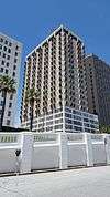 |
(#16000121) |
600 Leopard Street 27°47′47″N 97°23′48″W / 27.796455°N 97.396661°W |
Corpus Christi | |
| 2 | Britton-Evans House | 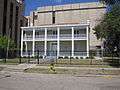 |
(#76002054) |
411 N. Upper Broadway 27°47′37″N 97°23′48″W / 27.793611°N 97.396597°W |
Corpus Christi | also known as the Centennial House |
| 3 | Broadway Bluff Improvement | 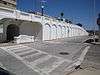 |
(#88001829) |
Roughly bounded by Upper and Lower Broadway, I-37, Mann and Mesquite Sts. 27°47′48″N 97°23′46″W / 27.796736°N 97.396181°W |
Corpus Christi | |
| 4 | Galvan Ballroom | 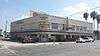 |
(#15000336) |
1632 Agnes 27°47′14″N 97°24′33″W / 27.787249°N 97.409076°W |
Corpus Christi | |
| 5 | Simon Gugenheim House | 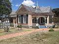 |
(#83003155) |
1601 N. Chaparral St. 27°48′24″N 97°23′43″W / 27.806528°N 97.395347°W |
Corpus Christi | |
| 6 | King Ranch | 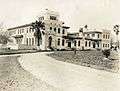 |
(#66000820) |
Kingsville and its environs 27°31′07″N 97°55′01″W / 27.518611°N 97.916944°W |
Kingsville | |
| 7 | Richard King House | 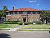 |
(#93000129) |
611 S. Upper Broadway 27°47′14″N 97°23′49″W / 27.787222°N 97.396806°W |
Corpus Christi | |
| 8 | S. Julius Lichtenstein House | 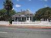 |
(#83003156) |
1617 N. Chaparral St. 27°48′25″N 97°23′44″W / 27.807083°N 97.395625°W |
Corpus Christi | now the Institute of Hispanic Culture |
| 9 | Old Nueces County Courthouse | 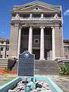 |
(#76002055) |
701 Mesquite at Belden Sts. 27°48′06″N 97°23′45″W / 27.801667°N 97.395833°W |
Corpus Christi | |
| 10 | Old St. Anthony's Catholic Church | 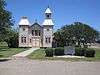 |
(#79003003) |
S. Violet Rd. and TX 44 27°46′57″N 97°35′40″W / 27.7825°N 97.594444°W |
Violet | |
| 11 | Oso Dune Site (41NU37) | Upload image | (#85001799) |
Address Restricted |
Corpus Christi | |
| 12 | Wynn Seale Junior High School | 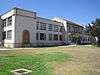 |
(#96000065) |
1701 Ayers St. 27°46′12″N 97°24′12″W / 27.77°N 97.40333°W |
Corpus Christi | |
| 13 | Sherman Building | 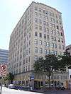 |
(#10000863) |
317 Peoples St. 27°47′48″N 97°23′37″W / 27.796667°N 97.393611°W |
Corpus Christi | |
| 14 | Charlotte Sidbury House | 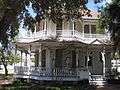 |
(#83003157) |
1609 N. Chaparral St. 27°48′25″N 97°23′44″W / 27.806806°N 97.395625°W |
Corpus Christi | |
| 15 | Tarpon Inn | 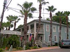 |
(#79003002) |
200 E. Cotter St 27°50′15″N 97°03′36″W / 27.8375°N 97.06°W |
Port Aransas | |
| 16 | Tucker Site (41NU46) | Upload image | (#85001940) |
Address Restricted |
Corpus Christi | |
| 17 | USS Lexington |  |
(#03001043) |
USS Lexington Museum on the Bay, 2914 North Shoreline Blvd. 27°48′54″N 97°23′20″W / 27.815°N 97.388889°W |
Corpus Christi |
See also
| Wikimedia Commons has media related to National Register of Historic Places in Nueces County, Texas. |
References
- ↑ The latitude and longitude information provided in this table was derived originally from the National Register Information System, which has been found to be fairly accurate for about 99% of listings. For about 1% of NRIS original coordinates, experience has shown that one or both coordinates are typos or otherwise extremely far off; some corrections may have been made. A more subtle problem causes many locations to be off by up to 150 yards, depending on location in the country: most NRIS coordinates were derived from tracing out latitude and longitudes off of USGS topographical quadrant maps created under the North American Datum of 1927, which differs from the current, highly accurate WGS84 GPS system used by most on-line maps. Chicago is about right, but NRIS longitudes in Washington are higher by about 4.5 seconds, and are lower by about 2.0 seconds in Maine. Latitudes differ by about 1.0 second in Florida. Some locations in this table may have been corrected to current GPS standards.
- ↑ "National Register of Historic Places: Weekly List Actions". National Park Service, United States Department of the Interior. Retrieved on December 2, 2016.
- ↑ Numbers represent an ordering by significant words. Various colorings, defined here, differentiate National Historic Landmarks and historic districts from other NRHP buildings, structures, sites or objects.
- ↑ National Park Service (2008-04-24). "National Register Information System". National Register of Historic Places. National Park Service.
- ↑ The eight-digit number below each date is the number assigned to each location in the National Register Information System database, which can be viewed by clicking the number.
 |
San Patricio County | | ||
| Jim Wells County | |
Gulf of Mexico | ||
| ||||
| | ||||
| Kleberg County |
| Topics | |
|---|---|
| Lists by states |
|
| Lists by insular areas | |
| Lists by associated states | |
| Other areas | |
| |
This article is issued from Wikipedia - version of the 11/18/2016. The text is available under the Creative Commons Attribution/Share Alike but additional terms may apply for the media files.