National Register of Historic Places listings in Monroe County, Mississippi
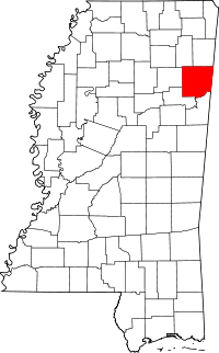
Location of Monroe County in Mississippi
This is a list of the National Register of Historic Places listings in Monroe County, Mississippi.
This is intended to be a complete list of the properties and districts on the National Register of Historic Places in Monroe County, Mississippi, United States. Latitude and longitude coordinates are provided for many National Register properties and districts; these locations may be seen together in a map.[1]
There are 35 properties and districts listed on the National Register in the county, including 1 National Historic Landmark.
- This National Park Service list is complete through NPS recent listings posted December 16, 2016.[2]
Current listings
| [3] | Name on the Register[4] | Image | Date listed[5] | Location | City or town | Description |
|---|---|---|---|---|---|---|
| 1 | Aberdeen City Hall | 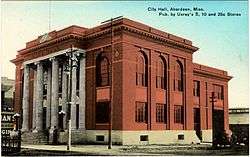 |
(#88000126) |
125 W. Commerce St. 33°49′30″N 88°32′41″W / 33.825°N 88.544722°W |
Aberdeen | |
| 2 | Aberdeen Downtown Historic District |  |
(#97000634) |
Roughly bounded by James, Quincy, Maple, and Washington Sts. 33°49′34″N 88°32′47″W / 33.826111°N 88.546389°W |
Aberdeen | |
| 3 | Adams-French House |  |
(#88000125) |
N. Meridian and Marshall Sts. 33°49′42″N 88°32′39″W / 33.828333°N 88.544167°W |
Aberdeen | |
| 4 | Baker Mound | Upload image | (#80002291) |
Address Restricted |
Aberdeen | |
| 5 | Building at 133 East Commerce Street | Upload image | (#88000136) |
133 E. Commerce St. 33°49′28″N 88°32′32″W / 33.824444°N 88.542222°W |
Aberdeen | |
| 6 | Buildings at 110-122 East Commerce Street | 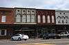 |
(#88000138) |
110-122 E. Commerce St. 33°49′31″N 88°32′34″W / 33.825278°N 88.542778°W |
Aberdeen | |
| 7 | Buildings at NW Corner of Commerce and Meridian Streets | Upload image | (#88000135) |
100-104 W. Commerce St. and 107 N. Meridian St. 33°49′31″N 88°32′38″W / 33.825278°N 88.543889°W |
Aberdeen | |
| 8 | Capt. Thomas Coopwood House | 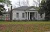 |
(#88000492) |
205 Thayer Ave. 33°49′25″N 88°33′42″W / 33.823611°N 88.561667°W |
Aberdeen | |
| 9 | Cotton Gin Port Site | Upload image | (#72000700) |
Along the Tombigbee River west of Amory[6] 33°58′15″N 88°32′35″W / 33.9708°N 88.5431°W |
Amory | |
| 10 | Crawford Site | Upload image | (#80002292) |
Address Restricted |
Aberdeen | |
| 11 | Reuben Davis House | 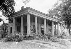 |
(#78001622) |
803 W. Commerce St. 33°49′30″N 88°33′22″W / 33.825°N 88.556111°W |
Aberdeen | |
| 12 | C.C. Day House | Upload image | (#88000123) |
517 S. Meridian St. 33°49′10″N 88°32′40″W / 33.819444°N 88.544444°W |
Aberdeen | |
| 13 | William A. Dunklin House | Upload image | (#88000122) |
301 High St. 33°49′08″N 88°32′46″W / 33.818889°N 88.546111°W |
Aberdeen | |
| 14 | Harmon Subdivision Historic District | Upload image | (#88000121) |
933-939 and 943 W. Commerce St. 33°49′30″N 88°33′36″W / 33.825°N 88.56°W |
Aberdeen | |
| 15 | Hester-Standifer Creek Site | Upload image | (#75001051) |
Address Restricted |
Amory | |
| 16 | John Holliday House | .jpg) |
(#88000120) |
609 S. Meridian St. 33°49′07″N 88°32′39″W / 33.818611°N 88.544167°W |
Aberdeen | |
| 17 | Inzer Site | Upload image | (#73001022) |
Address Restricted |
Amory | |
| 18 | Johnson-Butler House | Upload image | (#88000119) |
210 High St. 33°49′09″N 88°32′44″W / 33.819167°N 88.545556°W |
Aberdeen | |
| 19 | Lawson Site | Upload image | (#75001052) |
Address Restricted |
Amory | |
| 20 | Lenoir Plantation House | Upload image | (#91001893) |
Off Alternate U.S. Route 45, 3 miles south of its junction with Mississippi Highway 382 33°45′12″N 88°41′19″W / 33.753333°N 88.688611°W |
Prairie | |
| 21 | Mobile and Ohio Railroad Depot | Upload image | (#83003966) |
612 W. Commerce St. 33°49′34″N 88°33′05″W / 33.826111°N 88.551389°W |
Aberdeen | |
| 22 | Monroe County Courthouse | 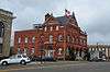 |
(#78001623) |
Courthouse Sq. 33°49′18″N 88°32′28″W / 33.821667°N 88.541111°W |
Aberdeen | |
| 23 | Monroe County Jail | Upload image | (#78001624) |
Off Mississippi Highway 8 33°52′17″N 88°26′33″W / 33.871389°N 88.4425°W |
Athens | Also known as Athens Jail |
| 24 | Mound Cemetery Site | Upload image | (#75001053) |
Address Restricted |
Amory | |
| 25 | North Aberdeen Historic District | Upload image | (#88000131) |
Roughly bounded by Meridian, Marshall, Long, and Commerce Sts. 33°49′36″N 88°32′48″W / 33.826667°N 88.546667°W |
Aberdeen | |
| 26 | Old Homestead | Upload image | (#88000124) |
503 W. Commerce 33°49′29″N 88°32′56″W / 33.824722°N 88.548889°W |
Aberdeen | |
| 27 | Francis M. Rogers House | Upload image | (#88002222) |
High and Hickory Sts. 33°49′07″N 88°32′44″W / 33.818611°N 88.545556°W |
Aberdeen | |
| 28 | Sadler House | Upload image | (#11000113) |
400 Marshall St. 33°49′42″N 88°32′51″W / 33.828333°N 88.5475°W |
Aberdeen | |
| 29 | South Central Aberdeen Historic District | Upload image | (#88000134) |
Roughly bounded by Locust, Washington, Franklin, and High Sts.; also roughly bounded by Madison, Meridian, High, and Long Sts. 33°49′18″N 88°32′49″W / 33.821667°N 88.546944°W |
Aberdeen | Second set of boundaries represents a boundary increase of September 10, 2004 |
| 30 | James Young Thompson House | Upload image | (#90001223) |
Old Cotton Gin Rd., ¼ mile north of U.S. Route 278 33°59′07″N 88°31′40″W / 33.985278°N 88.527778°W |
Amory | |
| 31 | U.S. Courthouse and Post Office | 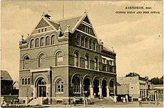 |
(#76001104) |
201 W. Commerce St. 33°49′29″N 88°32′41″W / 33.824722°N 88.544722°W |
Aberdeen | |
| 32 | US Post Office-Amory | Upload image | (#88000691) |
215 1st Ave. 33°59′09″N 88°29′18″W / 33.985833°N 88.488333°W |
Amory | |
| 33 | W.W. Watkins House | Upload image | (#91000387) |
600 W. Commerce St. 33°49′32″N 88°33′03″W / 33.825556°N 88.550833°W |
Aberdeen | |
| 34 | West Commerce Street Historic District |  |
(#88000128) |
721-919 and 730-900 W. Commerce St. 33°49′31″N 88°33′20″W / 33.825278°N 88.555556°W |
Aberdeen | |
| 35 | Word Mound | Upload image | (#80002293) |
Address Restricted |
Aberdeen |
See also
| Wikimedia Commons has media related to National Register of Historic Places in Monroe County, Mississippi. |
- List of National Historic Landmarks in Mississippi
- National Register of Historic Places listings in Mississippi
References
- ↑ The latitude and longitude information provided in this table was derived originally from the National Register Information System, which has been found to be fairly accurate for about 99% of listings. For about 1% of NRIS original coordinates, experience has shown that one or both coordinates are typos or otherwise extremely far off; some corrections may have been made. A more subtle problem causes many locations to be off by up to 150 yards, depending on location in the country: most NRIS coordinates were derived from tracing out latitude and longitudes off of USGS topographical quadrant maps created under the North American Datum of 1927, which differs from the current, highly accurate WGS84 GPS system used by most on-line maps. Chicago is about right, but NRIS longitudes in Washington are higher by about 4.5 seconds, and are lower by about 2.0 seconds in Maine. Latitudes differ by about 1.0 second in Florida. Some locations in this table may have been corrected to current GPS standards.
- ↑ "National Register of Historic Places: Weekly List Actions". National Park Service, United States Department of the Interior. Retrieved on December 16, 2016.
- ↑ Numbers represent an ordering by significant words. Various colorings, defined here, differentiate National Historic Landmarks and historic districts from other NRHP buildings, structures, sites or objects.
- ↑ National Park Service (2009-03-13). "National Register Information System". National Register of Historic Places. National Park Service.
- ↑ The eight-digit number below each date is the number assigned to each location in the National Register Information System database, which can be viewed by clicking the number.
- ↑ Location derived from its GNIS feature record; the NRIS lists the site as "Address Restricted"
| Topics | |
|---|---|
| Lists by states |
|
| Lists by insular areas | |
| Lists by associated states | |
| Other areas | |
| |
Municipalities and communities of Monroe County, Mississippi, United States | ||
|---|---|---|
| Cities | | |
| Towns | ||
| Village | ||
| CDPs | ||
| Other unincorporated communities | ||
| Ghost towns | ||
| Footnotes | ‡This town also has portions in adjacent county or counties | |
This article is issued from Wikipedia - version of the 5/20/2016. The text is available under the Creative Commons Attribution/Share Alike but additional terms may apply for the media files.