National Register of Historic Places listings in Meriwether County, Georgia
This is a list of properties and districts in Meriwether County, Georgia that are listed on the National Register of Historic Places (NRHP).
- This National Park Service list is complete through NPS recent listings posted December 16, 2016.[1]
Current listings
| [2] | Name on the Register | Image | Date listed[3] | Location | City or town | Description |
|---|---|---|---|---|---|---|
| 1 | Bulloch Family House | 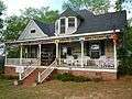 |
(#01001429) |
5634 Spring St. 32°53′36″N 84°40′29″W / 32.893333°N 84.674722°W |
Warm Springs | |
| 2 | Benjamin F. Bulloch House |  |
(#94000524) |
47 Bulloch St. 32°53′17″N 84°40′38″W / 32.888056°N 84.677222°W |
Warm Springs | Built in the Queen Anne style in 1893 by Warm Springs' co-founder, Benjamin F. Bulloch, the house was the location of "The Bulloch House Restaurant". The house was completely destroyed by a fire on June 10, 2015.[4] |
| 3 | Carmel Rural Historic District | 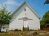 |
(#97000752) |
E of GA 85. Roughly bounded by Winky Branch, Gable and Sullivan Mill Rds., Flint R., and White Oak Cr. 33°10′22″N 84°32′14″W / 33.172778°N 84.537222°W |
Alvaton | |
| 4 | Champinole | 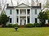 |
(#92001400) |
3920 GA Spur 109, 4 mi. NE of Greenville 33°03′15″N 84°38′50″W / 33.054167°N 84.647222°W |
Greenville | |
| 5 | Clarkland Farms | 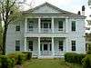 |
(#74000693) |
La Grange Rd. 33°01′30″N 84°43′45″W / 33.025°N 84.729167°W |
Greenville | |
| 6 | Eleanor Roosevelt School | 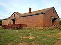 |
(#10000019) |
Parham St. at Leverette Hill Rd. 32°53′56″N 84°41′07″W / 32.898978°N 84.685169°W |
Warm Springs | |
| 7 | Greenville Historic District |  |
(#90000433) |
Bounded by Gresham, Gaston, Woodbury, Talbotton, Baldwin, Bottom, Martin, Terrell, LaGrange, and Newnan St. 33°01′34″N 84°42′51″W / 33.026111°N 84.714167°W |
Greenville | |
| 8 | Greenville Presbyterian Church and Cemetery | 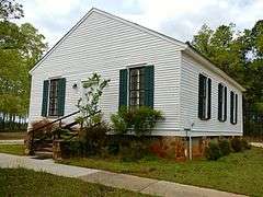 |
(#01001555) |
Greenville Rocky Mount Rd, off GA41/US27 Alt. 33°03′56″N 84°42′19″W / 33.065556°N 84.705278°W |
Greenville | |
| 9 | Harman-Watson-Matthews House |  |
(#73000628) |
SW of Greenville on Odessadale/Durand Rd. 32°59′21″N 84°49′36″W / 32.989167°N 84.826667°W |
Greenville | |
| 10 | Burwell O. Hill House | 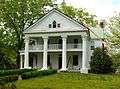 |
(#82002453) |
La Grange St. 33°01′33″N 84°43′23″W / 33.025833°N 84.723056°W |
Greenville | |
| 11 | Hiram Warner Hill House | 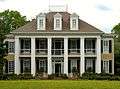 |
(#83000236) |
LaGrange St. 33°01′34″N 84°43′16″W / 33.026111°N 84.721111°W |
Greenville | |
| 12 | Jones-Florence Plantation | 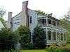 |
(#84001163) |
Off GA 109 33°01′24″N 84°49′04″W / 33.023333°N 84.817778°W |
Odessadale | |
| 13 | Lone Oak Academy | .JPG) |
(#01001536) |
4945 Lone Oak Rd. 33°10′19″N 84°48′51″W / 33.171944°N 84.814167°W |
Lone Oak | Built c. 1870. |
| 14 | Manchester Community Building | .JPG) |
(#01001537) |
105 E 2nd Ave. 32°51′07″N 84°36′54″W / 32.851944°N 84.615°W |
Manchester | |
| 15 | Mark Hall | Upload image | (#73000629) |
SW of Greenville off GA 18 32°57′18″N 84°45′03″W / 32.955°N 84.750833°W |
Greenville | Built in 1855. |
| 16 | Meriwether County Courthouse |  |
(#73000630) |
Court Sq. 33°01′42″N 84°42′45″W / 33.028333°N 84.7125°W |
Greenville | |
| 17 | Meriwether County Jail | 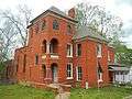 |
(#73000631) |
Reville St. and GA 27 A 33°01′46″N 84°42′42″W / 33.029444°N 84.711667°W |
Greenville | |
| 18 | Oakland | 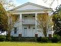 |
(#82002455) |
GA 41 32°55′52″N 84°41′47″W / 32.931111°N 84.696389°W |
Warm Springs | Built in 1829. Also known as "Oakland Plantation Inn". |
| 19 | William D. Phillips Log Cabin | Upload image | (#82002454) |
GA 54 33°09′38″N 84°51′40″W / 33.160556°N 84.861111°W |
Hogansville | The original structure has been destroyed. |
| 20 | Red Oak Creek Covered Bridge | _Red_Oak_Creek%2C_Huel_Brown_Road_(Cov%2C_Woodbury_vicinity_(Meriwether_County%2C_Georgia).jpg) |
(#73000632) |
N of Woodbury on Huel Brown Rd. 33°02′18″N 84°33′12″W / 33.038333°N 84.553333°W |
Woodbury | |
| 21 | Render Family Homestead | 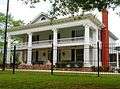 |
(#84001167) |
GA 18 33°00′56″N 84°42′34″W / 33.015556°N 84.709444°W |
Greenville | |
| 22 | Twin Oaks | 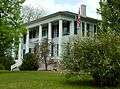 |
(#80001117) |
888 GA 100 33°02′16″N 84°42′54″W / 33.037778°N 84.715°W |
Greenville | |
| 23 | Warm Springs Historic District | 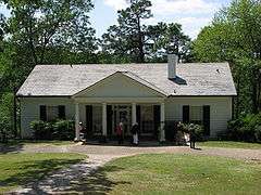 |
(#74000694) |
S of GA 194 and W of GA 85W 32°53′11″N 84°41′21″W / 32.886389°N 84.689167°W |
Warm Springs | US National Historic Landmark and a Georgia state historic site |
| 24 | White Oak Creek Covered Bridge | 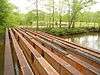 |
(#73000627) |
SE of Alvaton on Covered Bridge Rd. 33°09′00″N 84°33′02″W / 33.15°N 84.550556°W |
Alvaton | Bridge was built c. 1880 and destroyed by flood waters in the 1990s. The metal pilings and skeleton of the deck are all that remain. |
References
- ↑ "National Register of Historic Places: Weekly List Actions". National Park Service, United States Department of the Interior. Retrieved on December 16, 2016.
- ↑ Numbers represent an ordering by significant words. Various colorings, defined here, differentiate National Historic Landmarks and historic districts from other NRHP buildings, structures, sites or objects.
- ↑ The eight-digit number below each date is the number assigned to each location in the National Register Information System database, which can be viewed by clicking the number.
- ↑ "Preservation Posts - October 2015". us1.campaign-archive1.com. Retrieved 2016-08-01.
| Wikimedia Commons has media related to National Register of Historic Places in Meriwether County, Georgia. |
This article is issued from Wikipedia - version of the 8/1/2016. The text is available under the Creative Commons Attribution/Share Alike but additional terms may apply for the media files.