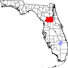
| [3] |
Name on the Register[4] |
Image |
Date listed[5] |
Location |
City or town |
Description |
|---|
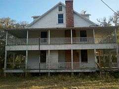
| 1 |
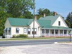
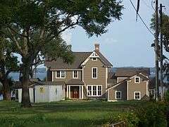
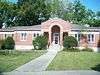
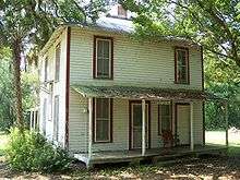
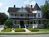
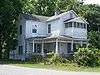
Armstrong House |
|
000000002000-06-09-0000June 9, 2000
(#00000638) |
18050 U.S. Route 301 North
29°24′44″N 82°06′38″W / 29.412222°N 82.110556°W / 29.412222; -82.110556 (Armstrong House) |
Citra |
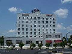
|
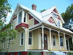
| 2 |
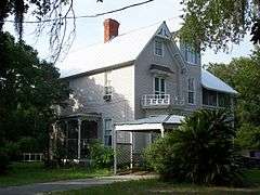
Alfred Ayer House |
|
000000001993-07-13-0000July 13, 1993
(#93000590) |
Alternate U.S. Routes 27/441 west of Oklawaha
29°02′21″N 81°57′00″W / 29.039167°N 81.95°W / 29.039167; -81.95 (Alfred Ayer House) |
Ocklawaha |
Part of the Early Residences of Rural Marion County MPS
|
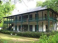
| 3 |
Thomas R. Ayer House |
|
000000001993-07-13-0000July 13, 1993
(#93000588) |
11885 Southeast 128th Place
29°02′09″N 81°57′22″W / 29.035833°N 81.956111°W / 29.035833; -81.956111 (Thomas R. Ayer House) |
Ocklawaha |
Part of the Early Residences of Rural Marion County MPS
|
| 4 |
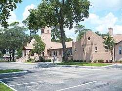
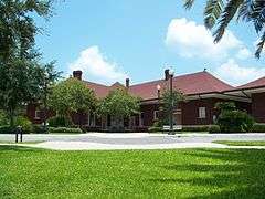
Belleview School |
|
000000001999-03-25-0000March 25, 1999
(#99000372) |
5343 Southeast Abshier Boulevard
29°03′37″N 82°03′35″W / 29.060278°N 82.059722°W / 29.060278; -82.059722 (Belleview School) |
Belleview |
|
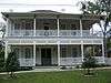
| 5 |
Gen. Robert Bullock House |
|
000000001993-07-13-0000July 13, 1993
(#93000589) |
Junction of Southeast 119th Court and Southeast 128 Place
29°02′06″N 81°57′15″W / 29.035°N 81.954167°W / 29.035; -81.954167 (Gen. Robert Bullock House) |
Ocklawaha |
Part of the Early Residences of Rural Marion County MPS
|
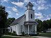
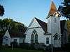
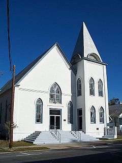
| 6 |
Citra Methodist Episcopal Church-South |
|
000000001998-03-05-0000March 5, 1998
(#98000177) |
2010 Northeast 180th Street
29°24′40″N 82°06′51″W / 29.411111°N 82.114167°W / 29.411111; -82.114167 (Citra Methodist Episcopal Church-South) |
Citra |
|
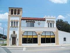
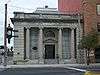
| 7 |
Coca-Cola Bottling Plant |
|
000000001979-05-04-0000May 4, 1979
(#79000682) |
939 North Magnolia Avenue
29°11′47″N 82°08′11″W / 29.196389°N 82.136389°W / 29.196389; -82.136389 (Coca-Cola Bottling Plant) |
Ocala |
|
| 8 |
Dunnellon Boomtown Historic District |
|
000000001988-12-08-0000December 8, 1988
(#88002807) |
Roughly bounded by McKinney Avenue, Illinois Street, Pennsylvania Avenue, and Cedar Street
29°03′05″N 82°27′48″W / 29.051389°N 82.463333°W / 29.051389; -82.463333 (Dunnellon Boomtown Historic District) |
Dunnellon |
|
| 9 |
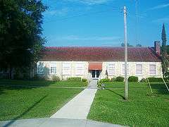
East Hall |
|
000000001995-07-28-0000July 28, 1995
(#95000924) |
307 Southeast 26th Terrace
29°11′03″N 82°06′02″W / 29.184167°N 82.100556°W / 29.184167; -82.100556 (East Hall) |
Ocala |
|
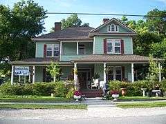
| 10 |
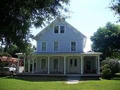
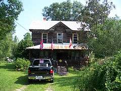
Robert W. Ferguson House |
|
000000001995-03-23-0000March 23, 1995
(#95000288) |
Off County Road 326, east of its junction with U.S. Route 27
29°17′00″N 82°17′13″W / 29.283333°N 82.286944°W / 29.283333; -82.286944 (Robert W. Ferguson House) |
Emathla |
Part of the Early Residences of Rural Marion County MPS
|
| 11 |
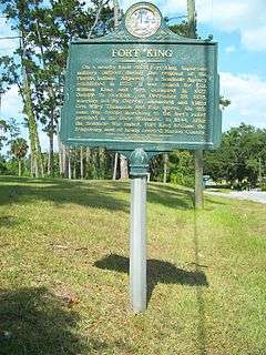
Fort King Site |
|
000000002004-02-24-0000February 24, 2004
(#04000320) |
Address Restricted
29°11′20″N 82°04′56″W / 29.1889°N 82.0822°W / 29.1889; -82.0822 (Fort King Site) |
Ocala |
A National Historic Landmark
|
| 12 |
James Riley Josselyn House |
|
000000001993-07-13-0000July 13, 1993
(#93000591) |
13845 Alternate U.S. Route 27
29°01′20″N 81°54′30″W / 29.022222°N 81.908333°W / 29.022222; -81.908333 (James Riley Josselyn House) |
Eastlake Weir |
Part of the Early Residences of Rural Marion County MPS
|
| 13 |
Kerr City Historic District |
|
000000001995-09-29-0000September 29, 1995
(#95001150) |
South of County Road 316, north of Lake Kerr
29°22′29″N 81°46′39″W / 29.374722°N 81.7775°W / 29.374722; -81.7775 (Kerr City Historic District) |
Fort McCoy |
|
| 14 |
Lake Lillian Neighborhood Historic District |
|
000000001999-08-20-0000August 20, 1999
(#99001012) |
Roughly bounded by Lillian Circle, Southeast Stetson Road, Southeast Mimosa Road, Southeast Earp Road, and the CSX railroad tracks
29°03′44″N 82°03′10″W / 29.062222°N 82.052778°W / 29.062222; -82.052778 (Lake Lillian Neighborhood Historic District) |
Belleview |
|
| 15 |
Lake Weir Yacht Club |
|
000000001993-04-22-0000April 22, 1993
(#93000319) |
New York Avenue
29°01′15″N 81°54′50″W / 29.020833°N 81.913889°W / 29.020833; -81.913889 (Lake Weir Yacht Club) |
Eastlake Weir |
|
| 16 |
Marion Hotel |
|
000000001980-10-16-0000October 16, 1980
(#80000955) |
108 North Magnolia Avenue
29°11′16″N 82°08′14″W / 29.187778°N 82.137222°W / 29.187778; -82.137222 (Marion Hotel) |
Ocala |
|
| 17 |
McIntosh Historic District |
|
000000001983-11-18-0000November 18, 1983
(#83003550) |
Roughly bounded by the railroad right-of-way, 10th Street, and Avenues C and H
29°26′57″N 82°13′11″W / 29.449167°N 82.219722°W / 29.449167; -82.219722 (McIntosh Historic District) |
McIntosh |
|
| 18 |
Morgan-Townsend House |
|
000000002013-09-26-0000September 26, 2013
(#13000794) |
13535 N. FL 19
29°21′00″N 81°44′03″W / 29.349889°N 81.734054°W / 29.349889; -81.734054 (Morgan-Townsend House) |
Salt Springs |
|
| 19 |
Mount Zion A.M.E. Church |
|
000000001979-12-17-0000December 17, 1979
(#79000683) |
623 South Magnolia Avenue
29°10′52″N 82°08′13″W / 29.181111°N 82.136944°W / 29.181111; -82.136944 (Mount Zion A.M.E. Church) |
Ocala |
|
| 20 |
Ocala Historic Commercial District |
|
000000001999-06-03-0000June 3, 1999
(#99000656) |
Roughly bounded by 1st Street NW, 1st Avenue SE, 2nd Street SW, and 1st Avenue SW
29°11′08″N 82°08′12″W / 29.185556°N 82.136667°W / 29.185556; -82.136667 (Ocala Historic Commercial District) |
Ocala |
|
| 21 |
Ocala Historic District |
|
000000001984-01-12-0000January 12, 1984
(#84000912) |
Roughly bounded by Broadway, Southeast 8th Street, Silver Springs Place, and Southeast 3rd, 13th, and Watula Avenues
29°11′00″N 82°07′42″W / 29.183333°N 82.128333°W / 29.183333; -82.128333 (Ocala Historic District) |
Ocala |
|
| 22 |
Ocala Union Station |
|
000000001997-12-22-0000December 22, 1997
(#97001557) |
531 Northeast First Avenue
29°11′31″N 82°08′09″W / 29.191944°N 82.135833°W / 29.191944; -82.135833 (Ocala Union Station) |
Ocala |
|
| 23 |
Old Fessenden Academy Historic District |
|
000000001994-09-29-0000September 29, 1994
(#94001141) |
4200 Northwest 90th Street
29°16′52″N 82°11′28″W / 29.281111°N 82.191111°W / 29.281111; -82.191111 (Old Fessenden Academy Historic District) |
Ocala |
|
| 24 |
Orange Springs Methodist Episcopal Church and Cemetery |
|
000000001988-12-22-0000December 22, 1988
(#88002805) |
State Road 315 and Church Street
29°30′09″N 81°56′44″W / 29.5025°N 81.945556°W / 29.5025; -81.945556 (Orange Springs Methodist Episcopal Church and Cemetery) |
Orange Springs |
|
| 25 |
T. W. Randall House |
|
000000001995-04-06-0000April 6, 1995
(#95000289) |
11685 Northeast County Highway C-314
29°13′57″N 81°57′39″W / 29.2325°N 81.960833°W / 29.2325; -81.960833 (T. W. Randall House) |
Silver Springs |
Part of the Early Residences of Rural Marion County MPS
|
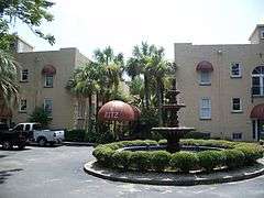
| 26 |
The Ritz Apartment |
|
000000001986-08-21-0000August 21, 1986
(#86001722) |
1205 East Silver Springs Boulevard
29°11′13″N 82°07′05″W / 29.186944°N 82.118056°W / 29.186944; -82.118056 (The Ritz Apartment) |
Ocala |
|
| 27 |
E. C. Smith House |
|
000000001990-05-24-0000May 24, 1990
(#90000806) |
507 Northeast 8th Avenue
29°11′32″N 82°07′47″W / 29.192222°N 82.129722°W / 29.192222; -82.129722 (E. C. Smith House) |
Ocala |
|
| 28 |
James W. Townsend House |
|
000000001988-10-17-0000October 17, 1988
(#88001849) |
Main and Spring Streets
29°30′25″N 81°56′39″W / 29.506944°N 81.944167°W / 29.506944; -81.944167 (James W. Townsend House) |
Orange Springs |
|
| 29 |
Tuscawilla Park Historic District |
|
000000001988-03-30-0000March 30, 1988
(#87002015) |
Northeast Fourth Street, Sanchez Avenue, Second Street, Tuscawilla Avenue, and Watula Street
29°11′21″N 82°07′57″W / 29.189167°N 82.1325°W / 29.189167; -82.1325 (Tuscawilla Park Historic District) |
Ocala |
|
| 30 |
West Ocala Historic District |
|
000000002002-06-27-0000June 27, 2002
(#02000682) |
Roughly Northwest 4th Street, West Silver Springs Boulevard, and Northwest 12th Avenue
29°11′17″N 82°08′47″W / 29.188056°N 82.146389°W / 29.188056; -82.146389 (West Ocala Historic District) |
Ocala |
|