National Register of Historic Places listings in Lincoln County, New Mexico
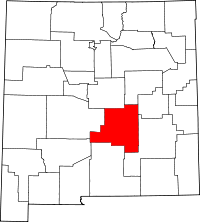
Location of Lincoln County in New Mexico
This is a list of the National Register of Historic Places listings in Lincoln County, New Mexico.
This is intended to be a complete list of the properties and districts on the National Register of Historic Places in Lincoln County, New Mexico, United States. Latitude and longitude coordinates are provided for many National Register properties and districts; these locations may be seen together in a map.[1]
There are 34 properties and districts listed on the National Register in the county, including 1 National Historic Landmark.
- This National Park Service list is complete through NPS recent listings posted December 2, 2016.[2]
| Bernalillo – Catron – Chaves – Cibola – Colfax – Curry – De Baca – Doña Ana – Eddy – Grant – Guadalupe – Harding – Hidalgo – Lea – Lincoln – Los Alamos – Luna – McKinley – Mora – Otero – Quay – Rio Arriba – Roosevelt – San Juan – San Miguel – Sandoval – Santa Fe – Sierra – Socorro – Taos – Torrance – Union – Valencia |
Current listings
| [3] | Name on the Register[4] | Image | Date listed[5] | Location | City or town | Description |
|---|---|---|---|---|---|---|
| 1 | Aguayo Family Homestead | Upload image | (#95001478) |
Tortolita Canyon, west of Nogal 33°32′06″N 105°45′09″W / 33.535°N 105.7525°W |
Nogal | |
| 2 | Archeological Site LA 12151 | Upload image | (#88001507) |
Address Restricted |
Lincoln | |
| 3 | Archeological Site LA 12153 | Upload image | (#88001508) |
Address Restricted |
Lincoln | |
| 4 | Archeological Site LA 12155 | Upload image | (#88001509) |
Address Restricted |
Lincoln | |
| 5 | Archeological Site LA 61201 | Upload image | (#88001510) |
Address Restricted |
Lincoln | |
| 6 | Archeological Site LA 61202 | Upload image | (#88001511) |
Address Restricted |
Lincoln | |
| 7 | Archeological Site LA 61204 | Upload image | (#88001512) |
Address Restricted |
Lincoln | |
| 8 | Archeological Site LA 61206 | Upload image | (#88001513) |
Address Restricted |
Lincoln | |
| 9 | Archeological Site LA 61208 | Upload image | (#88001514) |
Address Restricted |
Lincoln | |
| 10 | Archeological Site LA 61210 | Upload image | (#88001516) |
Address Restricted |
Lincoln | |
| 11 | Archeological Site LA 61211 | Upload image | (#88001515) |
Address Restricted |
Lincoln | |
| 12 | Archeological Site No. AR-03-08-01-051 | Upload image | (#90001251) |
Address Restricted |
White Oaks | |
| 13 | Archeological Site No. AR-03-08-01-052 | Upload image | (#90001252) |
Address Restricted |
White Oaks | |
| 14 | Carrizozo Commercial Historic District | Upload image | (#16000550) |
Roughly bounded by Brick & D Aves., 11th & 13th Sts. 33°38′36″N 105°52′32″W / 33.643406°N 105.875608°W |
Carrizozo | |
| 15 | Carrizozo Woman's Club | 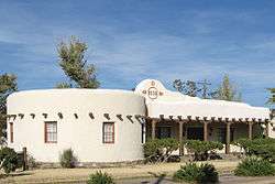 |
(#03000995) |
908 11th St. 33°38′33″N 105°52′43″W / 33.6425°N 105.878611°W |
Carrizozo | |
| 16 | El Paso And Southwestern Railway Water Supply System | Upload image | (#79001540) |
South of Nogal 33°29′30″N 105°40′44″W / 33.491667°N 105.678889°W |
Nogal | |
| 17 | Feather Cave | Upload image | (#74001198) |
Address Restricted |
Lincoln | |
| 18 | Fort Stanton | 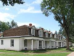 |
(99001679 #73001142; 99001679) |
7 miles southeast of Capitan near U.S. Route 380 33°29′40″N 105°31′35″W / 33.494444°N 105.526389°W |
Capitan | |
| 19 | Funston Site (AR-03-08-01-046) | Upload image | (#90001250) |
Address Restricted |
White Oaks | |
| 20 | Hopeful Lode | Upload image | (#95001014) |
Along Forest Rd. 108, 6 miles north of the junction of Forest Rds. 107 and 108, north of Bonito Lake 33°29′19″N 105°46′55″W / 33.488611°N 105.781944°W |
Nogal | |
| 21 | Peter and Henriette Wyeth Hurd House | 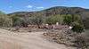 |
(#14001015) |
129 La Mancha Ln. 33°24′13″N 105°19′47″W / 33.403675°N 105.329725°W |
San Patricio | |
| 22 | Jicarilla Schoolhouse | 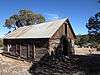 |
(#83001623) |
State Road 349 in the Lincoln National Forest 33°51′40″N 105°39′16″W / 33.861111°N 105.654444°W |
Jicarilla | |
| 23 | Luis A. and Susan B. Jimenez House and Studios | Upload image | (#14001016) |
Address Restricted |
Hondo vicinity | |
| 24 | Lincoln Historic District | .jpg) |
(#66000477) |
U.S. Route 380 33°29′41″N 105°22′56″W / 33.494722°N 105.382222°W |
Lincoln | |
| 25 | Mesa Ranger Station Site | Upload image | (#90001533) |
Address Restricted |
Nogal | |
| 26 | Monjeau Lookout | 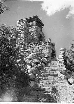 |
(#87002483) |
Lincoln National Forest 33°25′51″N 105°43′53″W / 33.430833°N 105.731389°W |
Villa Madonna | |
| 27 | New Mexico Military Institute Summer Camp, Main Building | Upload image | (#83001622) |
Carrizo Canyon 33°18′22″N 105°40′08″W / 33.306111°N 105.668889°W |
Ruidoso | |
| 28 | Nogal Mesa Kiva Site | Upload image | (#90001532) |
Address Restricted |
Nogal | |
| 29 | Nogal Mesa Site | Upload image | (#90001531) |
Address Restricted |
Nogal | |
| 30 | Old Dowlin Mill | 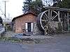 |
(#13000768) |
641 Sudderth Dr. 33°19′25″N 105°38′51″W / 33.323644°N 105.647578°W |
Ruidoso | |
| 31 | Paden's Drug Store |  |
(#05000204) |
1200-1208 E Ave. 33°38′35″N 105°52′42″W / 33.643056°N 105.878333°W |
Carrizozo | Now Roy's Ice Cream Parlour |
| 32 | Ruidoso Lookout Tower | Upload image | (#87002485) |
Lincoln National Forest 33°19′54″N 105°39′43″W / 33.331667°N 105.661944°W |
Ruidoso | |
| 33 | White Oaks Historic District | 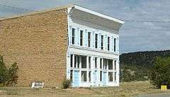 |
(#70000403) |
12 miles northeast of Carrizozo on State Road 349 33°45′03″N 105°45′22″W / 33.750833°N 105.756111°W |
White Oaks | |
| 34 | Wizard's Roost | Upload image | (#82004841) |
Address Restricted |
Capitan |
See also
| Wikimedia Commons has media related to National Register of Historic Places in Lincoln County, New Mexico. |
- List of National Historic Landmarks in New Mexico
- National Register of Historic Places listings in New Mexico
References
- ↑ The latitude and longitude information provided in this table was derived originally from the National Register Information System, which has been found to be fairly accurate for about 99% of listings. For about 1% of NRIS original coordinates, experience has shown that one or both coordinates are typos or otherwise extremely far off; some corrections may have been made. A more subtle problem causes many locations to be off by up to 150 yards, depending on location in the country: most NRIS coordinates were derived from tracing out latitude and longitudes off of USGS topographical quadrant maps created under the North American Datum of 1927, which differs from the current, highly accurate WGS84 GPS system used by most on-line maps. Chicago is about right, but NRIS longitudes in Washington are higher by about 4.5 seconds, and are lower by about 2.0 seconds in Maine. Latitudes differ by about 1.0 second in Florida. Some locations in this table may have been corrected to current GPS standards.
- ↑ "National Register of Historic Places: Weekly List Actions". National Park Service, United States Department of the Interior. Retrieved on December 2, 2016.
- ↑ Numbers represent an ordering by significant words. Various colorings, defined here, differentiate National Historic Landmarks and historic districts from other NRHP buildings, structures, sites or objects.
- ↑ National Park Service (2008-04-24). "National Register Information System". National Register of Historic Places. National Park Service.
- ↑ The eight-digit number below each date is the number assigned to each location in the National Register Information System database, which can be viewed by clicking the number.
| Topics | |
|---|---|
| Lists by states |
|
| Lists by insular areas | |
| Lists by associated states | |
| Other areas | |
| |
Municipalities and communities of Lincoln County, New Mexico, United States | ||
|---|---|---|
| City | | |
| Town | ||
| Villages | ||
| CDP | ||
| Other unincorporated communities | ||
| Ghost town | ||
This article is issued from Wikipedia - version of the 9/11/2016. The text is available under the Creative Commons Attribution/Share Alike but additional terms may apply for the media files.