National Register of Historic Places listings in Kingsbury County, South Dakota
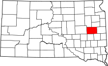
Location of Kingsbury County in South Dakota
This is a list of the National Register of Historic Places listings in Kingsbury County, South Dakota.
This is intended to be a complete list of the properties and districts on the National Register of Historic Places in Kingsbury County, South Dakota, United States. The locations of National Register properties and districts for which the latitude and longitude coordinates are included below, may be seen in a map.[1]
There are 20 properties and districts listed on the National Register in the county.
- This National Park Service list is complete through NPS recent listings posted December 2, 2016.[2]
Current listings
| [3] |
Name on the Register[4] |
Image |
Date listed[5] |
Location |
City or town |
Description |
|---|
| 1 |
Badger School District Number 18 |
Upload image |
000000002006-08-02-0000August 2, 2006
(#06000665) |
Junction of Main St. and 1st Ave.
44°29′12″N 97°12′30″W / 44.486667°N 97.208333°W / 44.486667; -97.208333 (Badger School District Number 18) |
Badger |
|
| 2 |
Bank of the Iroquois Building |
Upload image |
000000002002-05-30-0000May 30, 2002
(#02000576) |
Junction of Washita and Quapaw Sts.
44°22′01″N 97°51′01″W / 44.366944°N 97.850278°W / 44.366944; -97.850278 (Bank of the Iroquois Building) |
Iroquois |
|
| 3 |
Berger Farmstead |
Upload image |
000000002005-03-15-0000March 15, 2005
(#05000179) |
19802 446th Ave.
44°30′54″N 97°17′20″W / 44.515°N 97.288889°W / 44.515; -97.288889 (Berger Farmstead) |
Badger |
|
| 4 |
Central Dakota Flouring Mill Grain Elevator |
Upload image |
000000002002-05-30-0000May 30, 2002
(#02000573) |
202 E. Elm St.
44°21′47″N 97°07′50″W / 44.363056°N 97.130556°W / 44.363056; -97.130556 (Central Dakota Flouring Mill Grain Elevator) |
Arlington |
|
| 5 |
Chicago Northwestern Depot |
Upload image |
000000001976-12-12-0000December 12, 1976
(#76001739) |
Highway 25
44°23′09″N 97°32′50″W / 44.385833°N 97.547222°W / 44.385833; -97.547222 (Chicago Northwestern Depot) |
De Smet |
|
| 6 |
Esmond Methodist Episcopal Church and Township Hall |
Upload image |
000000002006-08-02-0000August 2, 2006
(#06000666) |
Junction of Center St. and Elm St.
44°15′53″N 97°46′19″W / 44.264722°N 97.771944°W / 44.264722; -97.771944 (Esmond Methodist Episcopal Church and Township Hall) |
Esmond |
|
| 7 |
Hetland School |
Upload image |
000000002002-05-30-0000May 30, 2002
(#02000572) |
Park St.
44°22′43″N 97°14′11″W / 44.378611°N 97.236389°W / 44.378611; -97.236389 (Hetland School) |
Hetland |
|
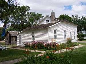
| 8 |
Ingalls House |
|
000000001975-04-21-0000April 21, 1975
(#75001717) |
210 3rd St., W.
44°23′07″N 97°33′17″W / 44.385278°N 97.554722°W / 44.385278; -97.554722 (Ingalls House) |
De Smet |
|
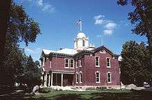
| 9 |
Kingsbury County Courthouse |
|
000000001977-09-22-0000September 22, 1977
(#77001249) |
Highway 25
44°23′10″N 97°32′41″W / 44.386111°N 97.544722°W / 44.386111; -97.544722 (Kingsbury County Courthouse) |
De Smet |
|
| 10 |
Lake Preston High School |
Upload image |
000000002003-10-24-0000October 24, 2003
(#03001074) |
300 1st St., NE.
44°21′48″N 97°22′24″W / 44.363333°N 97.373333°W / 44.363333; -97.373333 (Lake Preston High School) |
Lake Preston |
|
| 11 |
Lake Preston Tourist Park Historic District |
Upload image |
000000002002-05-30-0000May 30, 2002
(#02000574) |
Junction of U.S. Route 14 and S. Park Ave.
44°21′36″N 97°22′07″W / 44.36°N 97.368611°W / 44.36; -97.368611 (Lake Preston Tourist Park Historic District) |
Lake Preston |
|
| 12 |
Oldham Methodist Church |
Upload image |
000000001987-09-25-0000September 25, 1987
(#87001728) |
Main St. and Epton Ave.
44°13′41″N 97°18′40″W / 44.228056°N 97.311111°W / 44.228056; -97.311111 (Oldham Methodist Church) |
Oldham |
|
| 13 |
Omdalen Barn |
Upload image |
000000002006-08-02-0000August 2, 2006
(#06000667) |
44750 209th St.
44°21′22″N 97°15′38″W / 44.356111°N 97.260556°W / 44.356111; -97.260556 (Omdalen Barn) |
Lake Preston |
|
| 14 |
Peterson-Loriks House |
Upload image |
000000001980-06-19-0000June 19, 1980
(#80003726) |
In Oldham
44°13′48″N 97°18′30″W / 44.23°N 97.308333°W / 44.23; -97.308333 (Peterson-Loriks House) |
Oldham |
|
| 15 |
Railroad Camp Shanty |
Upload image |
000000001973-03-20-0000March 20, 1973
(#73001744) |
1st and Olivet Sts.
Coordinates missing |
De Smet |
|
| 16 |
Adam and Minnie Royhl House |
Upload image |
000000002001-06-06-0000June 6, 2001
(#01000638) |
203 S. 3rd St.
44°21′47″N 97°08′12″W / 44.363056°N 97.136667°W / 44.363056; -97.136667 (Adam and Minnie Royhl House) |
Arlington |
|
| 17 |
Thomas H. Ruth House |
Upload image |
000000001999-02-12-0000February 12, 1999
(#99000212) |
209 Poinset Ave.
44°23′03″N 97°33′05″W / 44.384167°N 97.551389°W / 44.384167; -97.551389 (Thomas H. Ruth House) |
De Smet |
|
| 18 |
South Dakota Dept. of Transportation Bridge No. 39-006-070 |
Upload image |
000000001993-12-09-0000December 9, 1993
(#93001297) |
Local road over Pearl Creek
44°26′27″N 97°50′26″W / 44.440833°N 97.840556°W / 44.440833; -97.840556 (South Dakota Dept. of Transportation Bridge No. 39-006-070) |
Iroquois |
|
| 19 |
Stark and Blanch Garage |
Upload image |
000000002007-11-19-0000November 19, 2007
(#07001212) |
204 S. Main
44°21′56″N 97°08′06″W / 44.365556°N 97.135°W / 44.365556; -97.135 (Stark and Blanch Garage) |
Arlington |
|
| 20 |
Olaf Stordahl Barn |
Upload image |
000000002002-05-30-0000May 30, 2002
(#02000575) |
45210 199th St.
44°30′15″N 97°09′52″W / 44.504167°N 97.164444°W / 44.504167; -97.164444 (Olaf Stordahl Barn) |
Arlington |
|
| [3] |
Name on the Register |
Image |
Date listed | Date removed |
Location |
City or town |
Summary |
|---|
| 1 |
Esmond Bridge |
Upload image |
000000001993-12-09-0000December 9, 1993
(#93001298) | 000000001999-12-15-0000December 15, 1999 |
Local rd. over Redstone Cr.
|
De Smet vicinity |
|
| 2 |
South Dakota Dept. of Transportation Bridge No. 39-176-100 |
Upload image |
000000001993-12-09-0000December 9, 1993
(#93001299) | 000000001999-12-15-0000December 15, 1999 |
Local rd. over unnamed cr.
|
De Smet vicinity |
|
See also
References
- ↑ The latitude and longitude information provided in this table was derived originally from the National Register Information System, which has been found to be fairly accurate for about 99% of listings. For about 1% of NRIS original coordinates, experience has shown that one or both coordinates are typos or otherwise extremely far off; some corrections may have been made. A more subtle problem causes many locations to be off by up to 150 yards, depending on location in the country: most NRIS coordinates were derived from tracing out latitude and longitudes off of USGS topographical quadrant maps created under the North American Datum of 1927, which differs from the current, highly accurate WGS84 GPS system used by most on-line maps. Chicago is about right, but NRIS longitudes in Washington are higher by about 4.5 seconds, and are lower by about 2.0 seconds in Maine. Latitudes differ by about 1.0 second in Florida. Some locations in this table may have been corrected to current GPS standards.
- ↑ "National Register of Historic Places: Weekly List Actions". National Park Service, United States Department of the Interior. Retrieved on December 2, 2016.
- 1 2 Numbers represent an ordering by significant words. Various colorings, defined here, differentiate National Historic Landmarks and historic districts from other NRHP buildings, structures, sites or objects.
- ↑ National Park Service (2008-04-24). "National Register Information System". National Register of Historic Places. National Park Service.
- ↑ The eight-digit number below each date is the number assigned to each location in the National Register Information System database, which can be viewed by clicking the number.
|
|---|
|
| Topics | |
|---|
|
| Lists by states | |
|---|
|
| Lists by insular areas | |
|---|
|
| Lists by associated states | |
|---|
|
| Other areas | |
|---|
|
-
 Portal Portal
-
 WikiProject WikiProject
|