| [3] |
Name on the Register[4] |
Image |
Date listed[5] |
Location |
City or town |
Description |
|---|
| 1 |
Alaska Central Railroad: Tunnel No. 1 |
|
000000001977-11-28-0000November 28, 1977
(#77001576) |
North of Seward
60°39′17″N 149°03′20″W / 60.654722°N 149.055556°W / 60.654722; -149.055556 (Alaska Central Railroad: Tunnel No. 1) |
Seward |
|
| 2 |
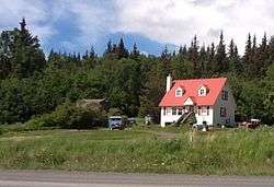
Alaska Nellie's Homestead |
Upload image |
000000001975-04-03-0000April 3, 1975
(#75002159) |
Mile 23 on the Seward Highway
60°24′05″N 149°21′32″W / 60.401389°N 149.358889°W / 60.401389; -149.358889 (Alaska Nellie's Homestead) |
Lawing |
|
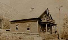
| 3 |
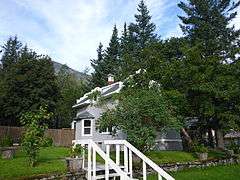
Ballaine House |
|
000000001978-07-12-0000July 12, 1978
(#78003429) |
437 3rd Ave.
60°06′25″N 149°26′25″W / 60.106944°N 149.440278°W / 60.106944; -149.440278 (Ballaine House) |
Seward |
|
| 4 |
Andrew Berg Cabin |
|
000000002000-04-21-0000April 21, 2000
(#00000385) |
30 miles southeast of Soldotna
60°07′03″N 150°37′40″W / 60.1175°N 150.627778°W / 60.1175; -150.627778 (Andrew Berg Cabin) |
Soldotna |
|
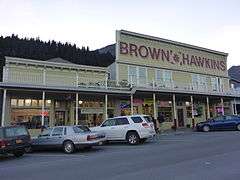
| 5 |
Brown & Hawkins Store |
|
000000001988-06-23-0000June 23, 1988
(#88000710) |
205, 207, and 209 4th Ave.
60°06′05″N 149°26′26″W / 60.101389°N 149.440556°W / 60.101389; -149.440556 (Brown & Hawkins Store) |
Seward |
|
| 6 |
Chugachik Island Site |
Upload image |
000000001976-08-19-0000August 19, 1976
(#76002279) |
Address Restricted
|
Homer |
|
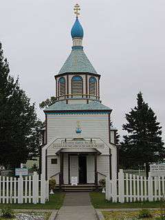
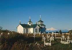
| 7 |
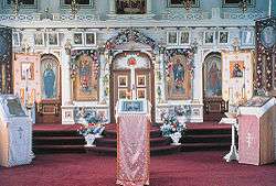
Church of the Assumption of the Virgin Mary |
|
000000001970-05-10-0000May 10, 1970
(#70000898) |
Mission and Overland Sts.
60°33′11″N 151°16′03″W / 60.552972°N 151.267611°W / 60.552972; -151.267611 (Church of the Assumption of the Virgin Mary) |
Kenai |
|
| 8 |
Coal Village Site |
Upload image |
000000001978-11-21-0000November 21, 1978
(#78003424) |
North of Port Graham
59°23′52″N 151°53′52″W / 59.397778°N 151.897778°W / 59.397778; -151.897778 (Coal Village Site) |
Port Graham |
|
| 9 |
Cooper Landing Historic District |
Upload image |
000000001986-08-21-0000August 21, 1986
(#86001475) |
Alaska Route 1
60°29′21″N 149°49′57″W / 60.489167°N 149.8325°W / 60.489167; -149.8325 (Cooper Landing Historic District) |
Cooper Landing |
|
| 10 |
Cooper Landing Post Office |
|
000000001978-05-23-0000May 23, 1978
(#78003425) |
Sterling Highway
60°29′25″N 149°49′57″W / 60.490278°N 149.8325°W / 60.490278; -149.8325 (Cooper Landing Post Office) |
Cooper Landing |
|
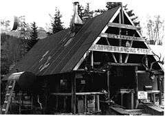
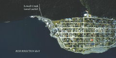
| 11 |
Diversion Tunnel |
|
000000001977-11-23-0000November 23, 1977
(#77001577) |
At Lowell Creek
60°06′14″N 149°27′09″W / 60.103889°N 149.4525°W / 60.103889; -149.4525 (Diversion Tunnel) |
Seward |
US Army Corps of Engineers tunnel that diverts Lowell Creek under Bear Mountain
|
| 12 |
Government Cable Office |
|
000000001980-01-04-0000January 4, 1980
(#80004574) |
218 6th Ave.
60°06′15″N 149°26′08″W / 60.104167°N 149.435556°W / 60.104167; -149.435556 (Government Cable Office) |
Seward |
|
| 13 |
Hirshey Mine |
Upload image |
000000001978-09-13-0000September 13, 1978
(#78003419) |
Southeast of Hope on Palmer Creek Rd.
60°47′39″N 149°31′05″W / 60.794167°N 149.518056°W / 60.794167; -149.518056 (Hirshey Mine) |
Hope |
|
| 14 |
Hoben Park |
|
000000002006-06-21-0000June 21, 2006
(#06000515) |
401 Railway Ave.
60°05′39″N 149°26′19″W / 60.094167°N 149.438611°W / 60.094167; -149.438611 (Hoben Park) |
Seward |
|
| 15 |
Victor Holm Cabin |
Upload image |
000000001977-04-13-0000April 13, 1977
(#77001573) |
Southwest of Kenai on Cohoe Rd. at the Kasilof River
60°22′08″N 151°18′14″W / 60.369°N 151.3038°W / 60.369; -151.3038 (Victor Holm Cabin) |
Kenai |
1890 cabin built by pioneering homesteader Victor Holm
|
| 16 |
Victor Holm Homestead |
Upload image |
000000002006-01-17-0000January 17, 2006
(#05000032) |
Cohoe Rd.
60°22′09″N 151°18′14″W / 60.3691°N 151.3038°W / 60.3691; -151.3038 (Victor Holm Homestead) |
Kasilof |
Encompasses entire Victor Holm property, including Victor Holm Cabin and other outbuildings
|
| 17 |
Holy Transfiguration of Our Lord Chapel |
|
000000001978-05-22-0000May 22, 1978
(#78003426) |
Sterling Highway
60°03′03″N 151°39′46″W / 60.050833°N 151.662778°W / 60.050833; -151.662778 (Holy Transfiguration of Our Lord Chapel) |
Ninilchik |
|
| 18 |
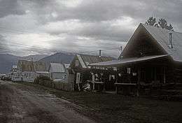
Hope Historic District |
|
000000001972-04-25-0000April 25, 1972
(#72001583) |
Mile 17 on Hope Rd.
60°55′11″N 149°38′22″W / 60.919722°N 149.639444°W / 60.919722; -149.639444 (Hope Historic District) |
Hope |
|
| 19 |
Harry A. Johnson Trapline Cabin |
Upload image |
000000002000-05-05-0000May 5, 2000
(#00000424) |
20 miles south of Hope
60°45′21″N 149°56′39″W / 60.755833°N 149.944167°W / 60.755833; -149.944167 (Harry A. Johnson Trapline Cabin) |
Hope |
|
| 20 |
Lauritsen Cabin |
Upload image |
000000001979-10-16-0000October 16, 1979
(#79003761) |
North of Moose Pass off Alaska Route 1
60°40′23″N 149°28′19″W / 60.673056°N 149.471944°W / 60.673056; -149.471944 (Lauritsen Cabin) |
Moose Pass |
|
| 21 |
Jesse Lee Home for Children |
Upload image |
000000001995-09-29-0000September 29, 1995
(#95001146) |
Swetmann Avenue
60°07′35″N 149°26′48″W / 60.126389°N 149.446667°W / 60.126389; -149.446667 (Jesse Lee Home for Children) |
Seward |
|
| 22 |
Magnetic Island Site |
Upload image |
000000002015-03-17-0000March 17, 2015
(#15000071) |
Address Restricted
|
Point Alsworth |
|
| 23 |
Moose River Site |
Upload image |
000000001978-12-20-0000December 20, 1978
(#78003427) |
Address Restricted
|
Sterling |
|
| 24 |
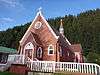
St. Nicholas Chapel |
|
000000001980-06-06-0000June 6, 1980
(#80004588) |
In Seldovia
59°25′49″N 151°42′40″W / 59.430278°N 151.711111°W / 59.430278; -151.711111 (St. Nicholas Chapel) |
Seldovia |
Russian Orthodox Church
|
| 25 |
St. Peter's Episcopal Church |
|
000000001979-12-21-0000December 21, 1979
(#79003762) |
2nd Ave. and Adams St.
60°06′07″N 149°26′41″W / 60.101944°N 149.444722°W / 60.101944; -149.444722 (St. Peter's Episcopal Church) |
Seward |
|
| 26 |
Sts. Sergius and Herman of Valaam Church |
|
000000001980-06-06-0000June 6, 1980
(#80004587) |
In Nanwalek
59°21′27″N 151°55′20″W / 59.3575°N 151.9222°W / 59.3575; -151.9222 (Sts. Sergius and Herman of Valaam Church) |
Nanwalek |
1930 Russian Orthodox Church (next to more recent one)
|
| 27 |
Selenie Lagoon Archeological Site |
Upload image |
000000001974-10-16-0000October 16, 1974
(#74002321) |
Address Restricted
|
Port Graham |
|
| 28 |
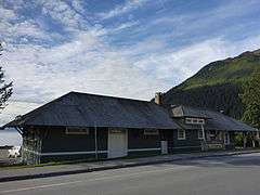
Seward Depot |
|
000000001987-07-16-0000July 16, 1987
(#87000652) |
501 Railway Ave.
60°05′39″N 149°26′19″W / 60.094167°N 149.438611°W / 60.094167; -149.438611 (Seward Depot) |
Seward |
|
| 29 |
Soldotna Post Office |
Upload image |
000000002008-09-17-0000September 17, 2008
(#08000904) |
Corner of E. Corral St. and the Kenai Spur Highway
60°29′35″N 151°04′01″W / 60.49311°N 151.06682°W / 60.49311; -151.06682 (Soldotna Post Office) |
Soldotna |
|
| 30 |
Sunrise City Historic District |
Upload image |
000000001997-08-19-0000August 19, 1997
(#97000892) |
At the mouth of Sixmile Creek, east of Hope[6]
60°53′23″N 149°25′16″W / 60.8897°N 149.4211°W / 60.8897; -149.4211 (Sunrise City Historic District) |
Hope |
|
| 31 |
Swetman House |
|
000000001978-02-17-0000February 17, 1978
(#78003430) |
325 5th Ave.
60°06′15″N 149°26′14″W / 60.104167°N 149.437222°W / 60.104167; -149.437222 (Swetman House) |
Seward |
|
| 32 |
Thorn-Stingley House |
|
000000002001-02-02-0000February 2, 2001
(#01000023) |
1660 East End Road
59°39′21″N 151°30′11″W / 59.655833°N 151.503056°W / 59.655833; -151.503056 (Thorn-Stingley House) |
Homer |
|
| 33 |
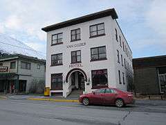
Van Gilder Hotel |
|
000000001980-12-02-0000December 2, 1980
(#80004575) |
307 Adams Street
60°06′11″N 149°26′27″W / 60.103056°N 149.440833°W / 60.103056; -149.440833 (Van Gilder Hotel) |
Seward |
|
| 34 |
Yukon Island Main Site |
|
000000001966-10-15-0000October 15, 1966
(#66000955) |
Yukon Island, 9 miles south of Homer[7]
59°31′22″N 151°29′55″W / 59.5229°N 151.4987°W / 59.5229; -151.4987 (Yukon Island Main Site) |
Homer |
|