National Register of Historic Places listings in Keith County, Nebraska
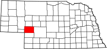
Location of Keith County in Nebraska
This is a list of the National Register of Historic Places listings in Keith County, Nebraska. It is intended to be a complete list of the properties and districts on the National Register of Historic Places in Keith County, Nebraska, United States. The locations of National Register properties and districts for which the latitude and longitude coordinates are included below, may be seen in a map.[1]
There are 13 properties and districts listed on the National Register in the county.
- This National Park Service list is complete through NPS recent listings posted December 16, 2016.[2]
Current listings
| [3] | Name on the Register | Image | Date listed[4] | Location | City or town | Description |
|---|---|---|---|---|---|---|
| 1 | Alkali Station | Upload image | (#16000776) |
Address Restricted |
Roscoe | |
| 2 | Archeological Site 25KH67 | Upload image | (#01001279) |
Address Restricted |
Paxton | |
| 3 | Archeological Site 25KH68 | Upload image | (#01001278) |
Address Restricted |
Brule | |
| 4 | Beauvais' Ranche Archeological Site | Upload image | (#75001096) |
Address Restricted |
Brule | |
| 5 | Leonidas A. Brandhoefer Mansion |  |
(#73001065) |
10th and Spruce Sts. 41°08′01″N 101°43′14″W / 41.133611°N 101.720556°W |
Ogallala | |
| 6 | California Hill | _ruts_1.JPG) |
(#74001126) |
West of Brule 41°06′02″N 101°58′54″W / 41.10056°N 101.98167°W |
Brule | |
| 7 | Diamond Springs Stage Station Site | 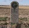 |
(#70000371) |
1 mile west of the Brule exit on Interstate 80 41°04′47″N 101°54′19″W / 41.079722°N 101.905278°W |
Brule | |
| 8 | Front Street | 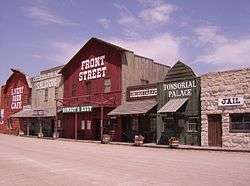 |
(#14001128) |
519 E. 1st St. 41°07′31″N 101°42′50″W / 41.1254°N 101.714°W |
Ogallala | |
| 9 | Dr. Burdette and Myrna Gainsforth House | 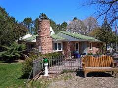 |
(#02001476) |
1300 East A St. 41°08′13″N 101°43′09″W / 41.136944°N 101.719167°W |
Ogallala | |
| 10 | Keystone Community Church |  |
(#79001447) |
McGinley St. 41°13′03″N 101°35′03″W / 41.2175°N 101.584167°W |
Keystone | |
| 11 | Roscoe State Aid Bridge | 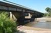 |
(#92000709) |
State Link 51B over the South Platte River, 0.5 miles southeast of Roscoe 41°07′33″N 101°34′35″W / 41.125833°N 101.576389°W |
Roscoe | |
| 12 | Standard Oil Red Crown Service Station | 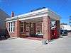 |
(#04000897) |
220 N. Spruce St. 41°07′34″N 101°43′09″W / 41.126111°N 101.719167°W |
Ogallala | |
| 13 | US Post Office-Ogallala | 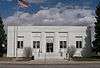 |
(#92000481) |
301 N. Spruce St. 41°07′37″N 101°43′09″W / 41.12688°N 101.71921°W |
Ogallala | One of 12 Nebraska post offices featuring a Section of Fine Arts mural, "Longhorns" (1938) by Frank Mechau.[5] |
Former listing
| [3] | Name on the Register | Image | Date listed | Date removed | Location | City or town | Summary |
|---|---|---|---|---|---|---|---|
| 1 | Welsch Motor Court-Erin Plaza Motor Court |  |
(#05001295) | 311 E. 1st St. 41°07′30″N 101°42′58″W / 41.125°N 101.716111°W |
Ogallala |
See also
| Wikimedia Commons has media related to National Register of Historic Places in Keith County, Nebraska. |
- List of National Historic Landmarks in Nebraska
- National Register of Historic Places listings in Nebraska
References
- ↑ The latitude and longitude information provided in this table was derived originally from the National Register Information System, which has been found to be fairly accurate for about 99% of listings. For about 1% of NRIS original coordinates, experience has shown that one or both coordinates are typos or otherwise extremely far off; some corrections may have been made. A more subtle problem causes many locations to be off by up to 150 yards, depending on location in the country: most NRIS coordinates were derived from tracing out latitude and longitudes off of USGS topographical quadrant maps created under the North American Datum of 1927, which differs from the current, highly accurate WGS84 GPS system used by most on-line maps. Chicago is about right, but NRIS longitudes in Washington are higher by about 4.5 seconds, and are lower by about 2.0 seconds in Maine. Latitudes differ by about 1.0 second in Florida. Some locations in this table may have been corrected to current GPS standards.
- ↑ "National Register of Historic Places: Weekly List Actions". National Park Service, United States Department of the Interior. Retrieved on December 16, 2016.
- 1 2 Numbers represent an ordering by significant words. Various colorings, defined here, differentiate National Historic Landmarks and historic districts from other NRHP buildings, structures, sites or objects.
- ↑ The eight-digit number below each date is the number assigned to each location in the National Register Information System database, which can be viewed by clicking the number.
- ↑ Ahlgren, Carol (August 1991). "National Register of Historic Places Multiple Property Documentation Form: Nebraska Post Offices Which Contain Section Artwork (1938-1942)" (PDF). Retrieved 2013-01-28.
| Topics | |
|---|---|
| Lists by states |
|
| Lists by insular areas | |
| Lists by associated states | |
| Other areas | |
| |
Municipalities and communities of Keith County, Nebraska, United States | ||
|---|---|---|
| City | ||
| Villages | ||
| CDPs | ||
| Unincorporated communities | ||
This article is issued from Wikipedia - version of the 12/1/2016. The text is available under the Creative Commons Attribution/Share Alike but additional terms may apply for the media files.