National Register of Historic Places listings in Juneau County, Wisconsin

Location of Juneau County in Wisconsin
This is a list of the National Register of Historic Places listings in Juneau County, Wisconsin. It is intended to provide a comprehensive listing of entries in the National Register of Historic Places that are located in Juneau County, Wisconsin. The locations of National Register properties for which the latitude and longitude coordinates are included below may be seen in a map.[1]
There are 9 properties and districts listed on the National Register in the county.
- This National Park Service list is complete through NPS recent listings posted December 2, 2016.[2]
Current listings
| [3] | Name on the Register | Image | Date listed[4] | Location | City or town | Description |
|---|---|---|---|---|---|---|
| 1 | Henry and Barbara Bierbaurer House | 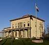 |
(#16000379) |
970 S. Monroe St. 43°52′11″N 90°09′58″W / 43.869758°N 90.166230°W |
New Lisbon | |
| 2 | Benjamin Boorman House | 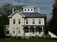 |
(#76000066) |
211 N. Union St. 43°47′57″N 90°04′15″W / 43.799167°N 90.070833°W |
Mauston | Victorian house begun in 1875 by Boorman, owner of Mauston's early grist mill, lumber mill and carding mill. Now the home of the Juneau County Historical Society.[5] |
| 3 | Cranberry Creek Archeological District |  |
(#84003689) |
W of the intersection of G and F, west of New Miner Coordinates missing |
Armenia | Mound complex constructed by Woodland people around 100-800 CE. Includes hundreds of low conical mounds, mostly in lines. Also a bird effigy and a bear or panther.[6] |
| 4 | Gee's Slough Mound Group | 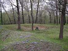 |
(#78000108) |
S of New Lisbon on Mounds View Rd Coordinates missing |
New Lisbon | Linear mounds, round mounds, and a running panther effigy mound constructed by Native Americans of the Woodland period.[7] |
| 5 | Juneau County Courthouse | 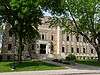 |
(#82001846) |
220 E. State St. 43°47′47″N 90°04′31″W / 43.796389°N 90.075278°W |
Mauston | Modern-styled courthouse built in 1938 with help of the WPA.[8] |
| 6 | Lemonweir Glyphs or Petroglyphs | 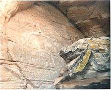 |
(#93001173) |
Address Restricted |
Kildare | Etchings of thunderbirds on a sandstone wall.[9] Also known as Twin Bluffs petroglyphs. |
| 7 | William and Mary Shelton Farmstead | 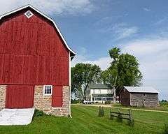 |
(#04000810) |
N2397 Cty Hwy K 43°43′37″N 90°03′32″W / 43.726944°N 90.058889°W |
Seven Mile Creek | Farmhouse started in 1863. In the 1920s the farm was state of the art, based on advice from university and farming magazines.[10] |
| 8 | Sprague Bridge | .jpg) |
(#94001574) |
Over the Yellow R. SE of Finley, Finley Township 44°11′11″N 90°06′15″W / 44.186389°N 90.104167°W |
Finley | Pratt half-hip pony truss bridge, constructed in 1913.[11] |
| 9 | Weston-Babcock House | 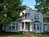 |
(#79000089) |
407 Main St. 44°01′20″N 90°04′12″W / 44.022222°N 90.07°W |
Necedah | Neoclassical home built in 1860 by Thomas Weston,[12] an early settler and founder of the lumber enterprise T. Weston & Co., which at one time sawed ten million board feet of lumber per year.[13] Charles Babcock founded the Necedah Bank. |
See also
- List of National Historic Landmarks in Wisconsin
- National Register of Historic Places listings in Wisconsin
References
- ↑ The latitude and longitude information provided is primarily from the National Register Information System, and has been found to be fairly accurate for about 99% of listings. For 1%, the location info may be way off. We seek to correct the coordinate information wherever it is found to be erroneous. Please leave a note in the Discussion page for this article if you believe any specific location is incorrect.
- ↑ "National Register of Historic Places: Weekly List Actions". National Park Service, United States Department of the Interior. Retrieved on December 2, 2016.
- ↑ Numbers represent an ordering by significant words. Various colorings, defined here, differentiate National Historic Landmarks and historic districts from other NRHP buildings, structures, sites or objects.
- ↑ The eight-digit number below each date is the number assigned to each location in the National Register Information System database, which can be viewed by clicking the number.
- ↑ "Mauston Wisconsin's Historic Boorman House". Juneau County Historical Society. Retrieved 2011-11-23.
- ↑ "Cranberry Creek Mound Group (No. 203)". Wisconsin State Natural Areas Program. Wisconsin Department of Natural Resources. Retrieved 2011-11-23.
- ↑ "New Lisbon Indian Mounds Park". Andrew Khitsun. Retrieved 2014-06-10.
- ↑ Balousek, Marv (1998). Wisconsin's Historic Courthouses. Illustrated by L. Roger Turner. Oregon, Wisc.: Badger Books, Inc. p. 63. ISBN 1-878569-56-2.
- ↑ "Western Wisconsin Rock Art Sites - Twin Bluffs". Mississippi Valley Archaeology Center. Retrieved 2011-11-26.
- ↑ "William and Mary Shelton Farmstead". Wisconsin National Register of Historic Places. Wisconsin Historical Society. Retrieved 2011-11-26.
- ↑ "Sprague Bridge, over Yellow River, Between Armenia and Necedah". Historic American Building Surveys, Engineering Records, Landscape Surveys. Library of Congress. Retrieved 2011-11-26.
- ↑ "Weston-Babcock House". Architecture and History Inventory. Wisconsin Historical Society. Retrieved 2013-06-18.
- ↑ "Necedah". Adams County Press. 1871-05-13. Retrieved 2013-06-18.
| Topics | |
|---|---|
| Lists by states |
|
| Lists by insular areas | |
| Lists by associated states | |
| Other areas | |
| |
Municipalities and communities of Juneau County, Wisconsin, United States | ||
|---|---|---|
| Cities | | |
| Villages | ||
| Towns | ||
| Unincorporated communities | ||
| Indian reservation | ||
| Footnotes | ‡This populated place also has portions in an adjacent county or counties | |
| Wikimedia Commons has media related to National Register of Historic Places in Juneau County, Wisconsin. |
This article is issued from Wikipedia - version of the 10/23/2016. The text is available under the Creative Commons Attribution/Share Alike but additional terms may apply for the media files.