| [3] |
Name on the Register |
Image |
Date listed[4] |
Location |
City or town |
Description |
|---|
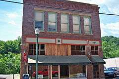
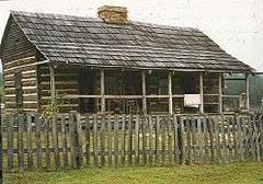
| 1 |
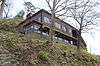
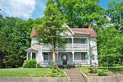
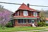
Archer House |
|
000000001989-01-26-0000January 26, 1989
(#88003162) |
170 Euclid St.
37°48′54″N 82°47′59″W / 37.815000°N 82.799861°W / 37.815000; -82.799861 (Archer House) |
Paintsville |
|
| 2 |
Blanton Archeological Site |
Upload image |
000000001975-07-30-0000July 30, 1975
(#75000782) |
Address Restricted
|
Oil Springs |
|
| 3 |
Jeff Bond House |
Upload image |
000000001989-01-26-0000January 26, 1989
(#88003174) |
Kentucky Route 172
37°55′31″N 82°57′22″W / 37.925278°N 82.956111°W / 37.925278; -82.956111 (Jeff Bond House) |
Redbush |
|
| 4 |
Dameron Shelter Archeological Site |
Upload image |
000000001975-08-01-0000August 1, 1975
(#75000784) |
Address Restricted
|
Paintsville |
|
| 5 |
Daniel Davis House |
Upload image |
000000001974-10-09-0000October 9, 1974
(#74000886) |
Northwest of Paintsville on U.S. Route 460
37°49′21″N 82°50′05″W / 37.8225°N 82.834722°W / 37.8225; -82.834722 (Daniel Davis House) |
Paintsville |
|
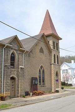
| 6 |
First Baptist Church |
|
000000001989-01-26-0000January 26, 1989
(#88003165) |
College St.
37°49′00″N 82°48′23″W / 37.816778°N 82.806389°W / 37.816778; -82.806389 (First Baptist Church) |
Paintsville |
|
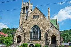
| 7 |
First Methodist Church |
|
000000001989-01-26-0000January 26, 1989
(#88003155) |
Main and Church Sts.
37°48′50″N 82°48′31″W / 37.813889°N 82.808611°W / 37.813889; -82.808611 (First Methodist Church) |
Paintsville |
|
| 8 |
First National Bank Building |
|
000000001989-01-26-0000January 26, 1989
(#88003154) |
Main and College Sts.
37°48′49″N 82°48′20″W / 37.813611°N 82.805556°W / 37.813611; -82.805556 (First National Bank Building) |
Paintsville |
|
| 9 |
Flat Gap School |
Upload image |
000000001989-01-26-0000January 26, 1989
(#88003187) |
Kentucky Route 689 near the junction with Kentucky Route 1092
37°56′11″N 82°53′15″W / 37.936389°N 82.8875°W / 37.936389; -82.8875 (Flat Gap School) |
Flat Gap |
|
| 10 |
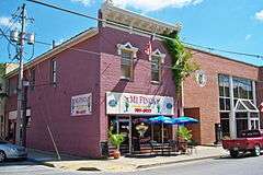
Foster Hardware |
|
000000001989-01-26-0000January 26, 1989
(#88003156) |
Main and Court Sts.
37°48′49″N 82°48′26″W / 37.813611°N 82.807111°W / 37.813611; -82.807111 (Foster Hardware) |
Paintsville |
|
| 11 |
John J. and Ellen Lemaster House |
Upload image |
000000001989-01-26-0000January 26, 1989
(#88003177) |
0.6 miles northeast of Low Gap on Low Gap Fork
37°52′11″N 82°56′26″W / 37.869722°N 82.940556°W / 37.869722; -82.940556 (John J. and Ellen Lemaster House) |
Low Gap |
|
| 12 |
Mayo Methodist Church |
|
000000001989-01-26-0000January 26, 1989
(#88003152) |
3rd St.
37°48′58″N 82°48′26″W / 37.816111°N 82.807222°W / 37.816111; -82.807222 (Mayo Methodist Church) |
Paintsville |
|
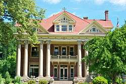
| 13 |
John C. C. Mayo Mansion and Office |
|
000000001974-05-03-0000May 3, 1974
(#74000887) |
405 3rd St.
37°48′59″N 82°48′29″W / 37.816389°N 82.808056°W / 37.816389; -82.808056 (John C. C. Mayo Mansion and Office) |
Paintsville |
|
| 14 |
Thomas Mayo House |
|
000000001989-01-26-0000January 26, 1989
(#88003166) |
228 2nd St.
37°48′54″N 82°48′35″W / 37.815000°N 82.809722°W / 37.815000; -82.809722 (Thomas Mayo House) |
Paintsville |
|
| 15 |
David McKenzie Log Cabin |
|
000000001982-08-26-0000August 26, 1982
(#82002728) |
McKenzie Branch
37°52′56″N 82°54′44″W / 37.882222°N 82.912222°W / 37.882222; -82.912222 (David McKenzie Log Cabin) |
Volga |
|
| 16 |
Meade Memorial Gymnasium |
|
000000001989-01-26-0000January 26, 1989
(#88003170) |
Junction of Kentucky Routes 40 and 2040
37°50′11″N 82°43′19″W / 37.836250°N 82.721944°W / 37.836250; -82.721944 (Meade Memorial Gymnasium) |
Williamsport |
|
| 17 |
Mine No. 5 Store |
|
000000001989-01-26-0000January 26, 1989
(#88003172) |
Kentucky Route 302
37°46′22″N 82°43′41″W / 37.772778°N 82.728056°W / 37.772778; -82.728056 (Mine No. 5 Store) |
Van Lear |
|
| 18 |
Ben Mollett Cabin |
Upload image |
000000001989-01-26-0000January 26, 1989
(#88003171) |
Off Kentucky Route 40 at Pigeon Roost Fork of Greasy Creek
37°48′09″N 82°42′19″W / 37.8025°N 82.705278°W / 37.8025; -82.705278 (Ben Mollett Cabin) |
Williamsport |
|
| 19 |
Lloyd Hamilton Mott House |
Upload image |
000000001989-01-26-0000January 26, 1989
(#88003175) |
Kentucky Route 172
37°56′26″N 82°57′06″W / 37.940556°N 82.951667°W / 37.940556; -82.951667 (Lloyd Hamilton Mott House) |
Redbush |
|
| 20 |
Oil Springs High School Gymnasium |
Upload image |
000000001989-01-26-0000January 26, 1989
(#88003178) |
Kentucky Route 580 off Kentucky Route 40
37°48′40″N 82°56′37″W / 37.811111°N 82.943611°W / 37.811111; -82.943611 (Oil Springs High School Gymnasium) |
Oil Springs |
|
| 21 |
Oil Springs Methodist Church |
Upload image |
000000001989-01-26-0000January 26, 1989
(#88003179) |
Junction of Kentucky Route 580 and Kentucky Route 40
37°48′37″N 82°56′35″W / 37.810278°N 82.943056°W / 37.810278; -82.943056 (Oil Springs Methodist Church) |
Oil Springs |
|
| 22 |
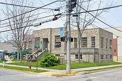
Paintsville City Hall |
|
000000001989-01-26-0000January 26, 1989
(#88003158) |
Main St. and spur of Kentucky Route 40
37°48′55″N 82°48′09″W / 37.815278°N 82.802500°W / 37.815278; -82.802500 (Paintsville City Hall) |
Paintsville |
|
| 23 |
Paintsville Country Club |
|
000000001989-01-26-0000January 26, 1989
(#88003168) |
Kentucky Route 1107 at Davis Branch
37°48′18″N 82°46′35″W / 37.805000°N 82.776389°W / 37.805000; -82.776389 (Paintsville Country Club) |
Paintsville |
|
| 24 |
Paintsville High School |
Upload image |
000000001989-01-26-0000January 26, 1989
(#88003163) |
2nd St.
37°48′55″N 82°48′24″W / 37.815278°N 82.806667°W / 37.815278; -82.806667 (Paintsville High School) |
Paintsville |
Formerly on the site of the current elementary school.
|
| 25 |
Paintsville Public Library |
|
000000001989-01-26-0000January 26, 1989
(#88003164) |
2nd St.
37°48′55″N 82°48′22″W / 37.815278°N 82.806111°W / 37.815278; -82.806111 (Paintsville Public Library) |
Paintsville |
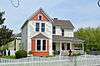
|
| 26 |
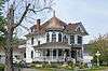
Patterson House |
|
000000001989-01-26-0000January 26, 1989
(#88003167) |
West and 2nd St.
37°48′53″N 82°48′40″W / 37.814861°N 82.811111°W / 37.814861; -82.811111 (Patterson House) |
Paintsville |
|
| 27 |
H.B. Rice Insurance Building |
|
000000001989-01-26-0000January 26, 1989
(#88003157) |
Court and Main Sts.
37°48′50″N 82°48′25″W / 37.813889°N 82.806833°W / 37.813889; -82.806833 (H.B. Rice Insurance Building) |
Paintsville |
|
| 28 |
Wiley Rice House |
Upload image |
000000001989-01-26-0000January 26, 1989
(#88003180) |
Kentucky Route 825 at Asa Creek
37°45′35″N 82°52′40″W / 37.759722°N 82.877778°W / 37.759722; -82.877778 (Wiley Rice House) |
Asa |
|
| 29 |
Salyer House |
Upload image |
000000001989-01-26-0000January 26, 1989
(#88003181) |
Off Kentucky Route 825 at Asa Creek
37°46′11″N 82°55′04″W / 37.769722°N 82.917778°W / 37.769722; -82.917778 (Salyer House) |
Asa |
|
| 30 |
Addison Salyer House |
Upload image |
000000001989-01-26-0000January 26, 1989
(#88003169) |
Off Kentucky Route 825 at Middle Fork of Jenny's Creek
37°45′50″N 82°50′43″W / 37.763889°N 82.845278°W / 37.763889; -82.845278 (Addison Salyer House) |
Paintsville |
|
| 31 |
Sparks Shelter Archeological Site |
Upload image |
000000001975-07-30-0000July 30, 1975
(#75000783) |
Address Restricted
|
Oil Springs |
|
| 32 |
Francis M. Stafford House |
|
000000001975-10-29-0000October 29, 1975
(#75000785) |
102 Broadway
37°48′45″N 82°48′21″W / 37.812417°N 82.805833°W / 37.812417; -82.805833 (Francis M. Stafford House) |
Paintsville |
|
| 33 |
Stambaugh Church of Christ |
Upload image |
000000001989-01-26-0000January 26, 1989
(#88003182) |
Kentucky Route 1559 at Frog Ornery Branch
37°53′25″N 82°48′26″W / 37.890278°N 82.807222°W / 37.890278; -82.807222 (Stambaugh Church of Christ) |
Stambaugh |
|
| 34 |
Stambaugh House |
Upload image |
000000001989-01-26-0000January 26, 1989
(#88003183) |
Kentucky Route 1559 at Van Hoose Branch
37°53′28″N 82°49′11″W / 37.891111°N 82.819722°W / 37.891111; -82.819722 (Stambaugh House) |
Stambaugh |
|
| 35 |
Judge Jim Turner House |
|
000000001989-01-26-0000January 26, 1989
(#88003153) |
315 3rd St.
37°48′56″N 82°48′31″W / 37.815556°N 82.808611°W / 37.815556; -82.808611 (Judge Jim Turner House) |
Paintsville |
|
| 36 |
Webb House |
|
000000001989-01-26-0000January 26, 1989
(#88003160) |
139 Main St.
37°48′52″N 82°48′08″W / 37.814444°N 82.802222°W / 37.814444; -82.802222 (Webb House) |
Paintsville |
|
| 37 |
Byrd and Leona Webb House |
|
000000001989-01-26-0000January 26, 1989
(#88003159) |
137 Main St.
37°48′52″N 82°48′09″W / 37.814444°N 82.802500°W / 37.814444; -82.802500 (Byrd and Leona Webb House) |
Paintsville |
|
| 38 |
Tobe Wiley House |
|
000000001989-01-26-0000January 26, 1989
(#88003161) |
141 Euclid St.
37°48′52″N 82°48′07″W / 37.814444°N 82.802083°W / 37.814444; -82.802083 (Tobe Wiley House) |
Paintsville |
|
| 39 |
Williams House |
Upload image |
000000001989-01-26-0000January 26, 1989
(#88003173) |
Kentucky Route 689/Elna Rd.
37°55′17″N 82°57′25″W / 37.921389°N 82.956944°W / 37.921389; -82.956944 (Williams House) |
Redbush |
|
.jpg)
.jpg)