National Register of Historic Places listings in Jersey County, Illinois
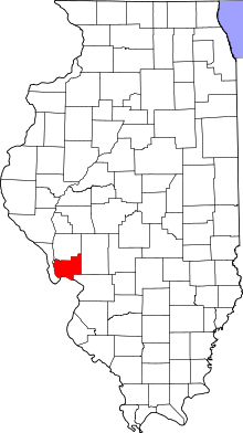
Location of Jersey County in Illinois
This is a list of the National Register of Historic Places listings in Jersey County, Illinois.
This is intended to be a complete list of the properties and districts on the National Register of Historic Places in Jersey County, Illinois, United States. Latitude and longitude coordinates are provided for many National Register properties and districts; these locations may be seen together in a map.[1]
There are 19 properties and districts listed on the National Register in the county.
- This National Park Service list is complete through NPS recent listings posted December 16, 2016.[2]
Current listings
| [3] |
Name on the Register |
Image |
Date listed[4] |
Location |
City or town |
Description |
|---|
| 1 |
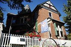
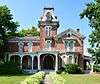
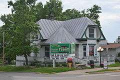
Charles Brainerd House |
|
000000001998-02-05-0000February 5, 1998
(#98000065) |
420 E. Main St. (Illinois Route 100)
38°58′19″N 90°25′45″W / 38.971944°N 90.429167°W / 38.971944; -90.429167 (Charles Brainerd House) |
Grafton |
|
| 2 |
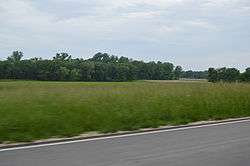
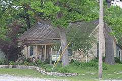
Duncan Farm |
|
000000001982-08-24-0000August 24, 1982
(#82002542) |
Southern side of Illinois Route 100, ½ mile west of Brussels Ferry[5]
38°58′05″N 90°30′49″W / 38.968056°N 90.513611°W / 38.968056; -90.513611 (Duncan Farm) |
Grafton |
|
| 3 |
Elsah Historic District |
|
000000001973-07-27-0000July 27, 1973
(#73000706) |
North of the McAdams Highway
38°57′15″N 90°21′37″W / 38.954167°N 90.360189°W / 38.954167; -90.360189 (Elsah Historic District) |
Elsah |
|
| 4 |
Fisher-Chapman Farmstead |
|
000000002012-02-15-0000February 15, 2012
(#12000028) |
24818 Homeridge Dr.
39°08′29″N 90°20′42″W / 39.141436°N 90.345116°W / 39.141436; -90.345116 (Fisher-Chapman Farmstead) |
Jerseyville |
|
| 5 |
Col. William H. Fulkerson Farmstead |
|
000000001998-08-06-0000August 6, 1998
(#98000977) |
1510 N. State St. (US Highway 67)
39°08′52″N 90°20′54″W / 39.147778°N 90.348333°W / 39.147778; -90.348333 (Col. William H. Fulkerson Farmstead) |
Jerseyville |
|
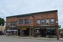
| 6 |
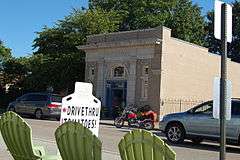
Grafton Bank |
|
000000001994-02-16-0000February 16, 1994
(#94000016) |
225 E. Main St. (Illinois Route 100)
38°58′10″N 90°25′55″W / 38.969444°N 90.431944°W / 38.969444; -90.431944 (Grafton Bank) |
Grafton |
|
| 7 |
Grafton Historic District |
|
000000001994-02-16-0000February 16, 1994
(#94000020) |
105-225 and 24-214 W. Main St. (Illinois Route 100), and stone wharf at Maple St.
38°58′09″N 90°26′16″W / 38.969167°N 90.437778°W / 38.969167; -90.437778 (Grafton Historic District) |
Grafton |
|
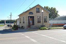
| 8 |
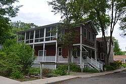
Hamilton Primary School |
|
000000001998-08-06-0000August 6, 1998
(#98000975) |
200 ft. west of the intersection of Otterville and McClusky Rds.
39°03′04″N 90°23′50″W / 39.051056°N 90.397295°W / 39.051056; -90.397295 (Hamilton Primary School) |
Otterville |
|
| 9 |
Jersey County Courthouse |
|
000000001986-05-08-0000May 8, 1986
(#86001008) |
Courthouse Square (bordered by W. Pearl, N. Lafayette, W. Exchange, and N. Washington Streets)
39°07′08″N 90°19′44″W / 39.118889°N 90.328889°W / 39.118889; -90.328889 (Jersey County Courthouse) |
Jerseyville |
|
| 10 |
Jerseyville Downtown Historic District |
|
000000001986-12-29-0000December 29, 1986
(#86003528) |
Roughly bounded by Spruce, N. Lafayette, Prairie, and N. Jefferson Streets
39°07′07″N 90°19′41″W / 39.118611°N 90.328056°W / 39.118611; -90.328056 (Jerseyville Downtown Historic District) |
Jerseyville |
|
| 11 |
Paris Mason Building |
|
000000001994-02-16-0000February 16, 1994
(#94000017) |
100 N. Springfield St.
38°58′17″N 90°27′01″W / 38.971389°N 90.450278°W / 38.971389; -90.450278 (Paris Mason Building) |
Grafton |
|
| 12 |
John and Amelia McClintock House |
|
000000001994-02-16-0000February 16, 1994
(#94000019) |
321 E. Main St. (Illinois Route 100)
38°58′10″N 90°25′50″W / 38.969583°N 90.430417°W / 38.969583; -90.430417 (John and Amelia McClintock House) |
Grafton |
|
| 13 |
New Piasa Chautauqua Historic District |
|
000000001982-06-15-0000June 15, 1982
(#82002541) |
Off McAdams Parkway
38°57′57″N 90°23′05″W / 38.965833°N 90.384722°W / 38.965833; -90.384722 (New Piasa Chautauqua Historic District) |
Chautauqua |
|
| 14 |
Nutwood Site |
Upload image |
000000001979-02-09-0000February 9, 1979
(#79003784) |
Western side of Illinois Route 100, 500 feet south of the Narrows Creek bridge[6]
39°04′54″N 90°33′23″W / 39.08166°N 90.55638°W / 39.08166; -90.55638 (Nutwood Site) |
Nutwood |
|
| 15 |
Pere Marquette State Park Lodge and Cabins |
Upload image |
000000001985-03-04-0000March 4, 1985
(#85002405) |
Box 158
38°58′18″N 90°32′28″W / 38.971667°N 90.541111°W / 38.971667; -90.541111 (Pere Marquette State Park Lodge and Cabins) |
Grafton |
|
| 16 |
Principia College Historic District |
|
000000001993-04-19-0000April 19, 1993
(#93001605) |
River Rd.
38°57′01″N 90°21′01″W / 38.950278°N 90.350278°W / 38.950278; -90.350278 (Principia College Historic District) |
Elsah |
|
| 17 |
Ruebel Hotel |
|
000000001994-02-16-0000February 16, 1994
(#94000015) |
207-215 E. Main St. (Illinois Route 100)
38°58′11″N 90°25′56″W / 38.969722°N 90.432222°W / 38.969722; -90.432222 (Ruebel Hotel) |
Grafton |
|
| 18 |
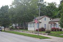
Slaten-LaMarsh House |
|
000000001994-02-16-0000February 16, 1994
(#94000018) |
25 E. Main St. (Illinois Route 100)
38°58′10″N 90°26′03″W / 38.969444°N 90.434167°W / 38.969444; -90.434167 (Slaten-LaMarsh House) |
Grafton |
|
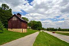
| 19 |
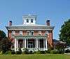
Smith-Duncan House and Eastman Barn |
|
000000001999-11-22-0000November 22, 1999
(#99001379) |
Illinois Route 100 at Pere Marquette State Park, 2,000 feet (610 m) west of Deer Lick Hollow
38°58′09″N 90°30′43″W / 38.969167°N 90.511944°W / 38.969167; -90.511944 (Smith-Duncan House and Eastman Barn) |
Grafton |
|
See also
References
- ↑ The latitude and longitude information provided in this table was derived originally from the National Register Information System, which has been found to be fairly accurate for about 99% of listings. For about 1% of NRIS original coordinates, experience has shown that one or both coordinates are typos or otherwise extremely far off; some corrections may have been made. A more subtle problem causes many locations to be off by up to 150 yards, depending on location in the country: most NRIS coordinates were derived from tracing out latitude and longitudes off of USGS topographical quadrant maps created under the North American Datum of 1927, which differs from the current, highly accurate WGS84 GPS system used by most on-line maps. Chicago is about right, but NRIS longitudes in Washington are higher by about 4.5 seconds, and are lower by about 2.0 seconds in Maine. Latitudes differ by about 1.0 second in Florida. Some locations in this table may have been corrected to current GPS standards.
- ↑ "National Register of Historic Places: Weekly List Actions". National Park Service, United States Department of the Interior. Retrieved on December 16, 2016.
- ↑ Numbers represent an ordering by significant words. Various colorings, defined here, differentiate National Historic Landmarks and historic districts from other NRHP buildings, structures, sites or objects.
- ↑ The eight-digit number below each date is the number assigned to each location in the National Register Information System database, which can be viewed by clicking the number.
- ↑ Wagner, Suzanne. National Register of Historic Places Inventory/Nomination: Duncan Farm. National Park Service, 1981-07-30, 5.
- ↑ Maruszak, Kathleen. National Register of Historic Places Inventory/Nomination: Nutwood Site. National Park Service, 1977-02, 5.
|
|---|
|
| Topics | |
|---|
|
| Lists by states | |
|---|
|
| Lists by insular areas | |
|---|
|
| Lists by associated states | |
|---|
|
| Other areas | |
|---|
|
-
 Portal Portal
-
 WikiProject WikiProject
|


.jpg)