National Register of Historic Places listings in Iron County, Utah

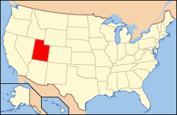
Location of Iron County in Utah
This is a list of the National Register of Historic Places listings in Iron County, Utah.
This is intended to be a complete list of the properties and districts on the National Register of Historic Places in Iron County, Utah, United States. Latitude and longitude coordinates are provided for many National Register properties and districts; these locations may be seen together in a map.[1]
There are 19 properties and districts listed on the National Register in the county. One other site in the county was once listed on the Register, but has since been removed.
- This National Park Service list is complete through NPS recent listings posted December 2, 2016.[2]
Current listings
| [3] |
Name on the Register[4] |
Image |
Date listed[5] |
Location |
City or town |
Description |
|---|
| 1 |
Caretaker's Cabin |
|
000000001983-08-04-0000August 4, 1983
(#83004385) |
Off State Route 14
37°36′55″N 112°50′12″W / 37.615278°N 112.836667°W / 37.615278; -112.836667 (Caretaker's Cabin) |
Cedar City |
|
| 2 |
Cedar City Historic District |
Upload image |
000000002004-07-07-0000July 7, 2004
(#04000677) |
Roughly bounded by 100 West and 300 West, College Ave., and 400 South
37°40′23″N 113°03′51″W / 37.673056°N 113.064167°W / 37.673056; -113.064167 (Cedar City Historic District) |
Cedar City |
|
| 3 |
Cedar City Railroad Depot |
Upload image |
000000001984-08-09-0000August 9, 1984
(#84002184) |
220 N. Main St.
37°40′53″N 113°03′41″W / 37.681389°N 113.061389°W / 37.681389; -113.061389 (Cedar City Railroad Depot) |
Cedar City |
|
| 4 |
Ensign-Smith House |
|
000000001983-05-19-0000May 19, 1983
(#83004400) |
96 N. Main St.
37°53′12″N 112°46′26″W / 37.886667°N 112.773889°W / 37.886667; -112.773889 (Ensign-Smith House) |
Paragonah |
|
| 5 |
Evans Mound (42IN40) |
|
000000001985-10-24-0000October 24, 1985
(#85003387) |
Address Restricted[6]
|
Summit |
|
| 6 |
Gold Spring |
|
000000001977-07-21-0000July 21, 1977
(#77001305) |
Address Restricted[6]
|
Modena |
|
| 7 |
Long Flat Site |
|
000000001979-11-01-0000November 1, 1979
(#79002496) |
Address Restricted[6]
|
Parowan |
|
| 8 |
William and Julia Lyman House |
Upload image |
000000002000-04-06-0000April 6, 2000
(#00000355) |
191 S. Main St.
37°50′22″N 112°49′35″W / 37.839444°N 112.826389°W / 37.839444; -112.826389 (William and Julia Lyman House) |
Parowan |
|
| 9 |
Meeks-Green Farmstead |
Upload image |
000000001994-04-15-0000April 15, 1994
(#94000295) |
Approximately 40 N. 400 West
37°50′34″N 112°50′08″W / 37.842778°N 112.835556°W / 37.842778; -112.835556 (Meeks-Green Farmstead) |
Parowan |
|
| 10 |
Modena Elementary School |
Upload image |
000000001985-04-01-0000April 1, 1985
(#85000806) |
About 150 N. Main St.
37°48′00″N 113°55′29″W / 37.8°N 113.924722°W / 37.8; -113.924722 (Modena Elementary School) |
Modena |
|
| 11 |
Old Irontown |
|
000000001971-05-14-0000May 14, 1971
(#71000843) |
About 22 miles (35 km) west of Cedar City, 3 miles (4.8 km) south of State Route 56
37°36′00″N 113°26′56″W / 37.6°N 113.448889°W / 37.6; -113.448889 (Old Irontown) |
Cedar City |
|
| 12 |
Old Main and Science Buildings |
|
000000001984-08-21-0000August 21, 1984
(#84002186) |
Southern Utah University campus
37°40′32″N 113°04′03″W / 37.675556°N 113.0675°W / 37.675556; -113.0675 (Old Main and Science Buildings) |
Cedar City |
|
| 13 |
Daniel R. and Sophia G. Page House |
Upload image |
000000001985-05-09-0000May 9, 1985
(#85000961) |
Richie Flat at the western edge of the Harmony Mountains
37°34′03″N 113°25′24″W / 37.5675°N 113.423333°W / 37.5675; -113.423333 (Daniel R. and Sophia G. Page House) |
Page Ranch |
|
| 14 |
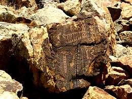
Parowan Gap Petroglyphs |
|
000000001975-10-10-0000October 10, 1975
(#75001806) |
10.5 miles (16.9 km) west of Main Street in Parowan[7]
37°54′35″N 112°59′07″W / 37.909722°N 112.985278°W / 37.909722; -112.985278 (Parowan Gap Petroglyphs) |
Parowan |
|
| 15 |
Parowan Meetinghouse |
|
000000001976-05-06-0000May 6, 1976
(#76001818) |
Center block of Main St., between Center and 100 South St.
37°50′28″N 112°49′41″W / 37.841111°N 112.828056°W / 37.841111; -112.828056 (Parowan Meetinghouse) |
Parowan |
|
| 16 |
Jesse N. Smith House |
Upload image |
000000001975-06-20-0000June 20, 1975
(#75001807) |
45 W. 100 South
37°50′24″N 112°49′39″W / 37.84°N 112.8275°W / 37.84; -112.8275 (Jesse N. Smith House) |
Parowan |
|
| 17 |
US Post Office-Cedar City Main |
Upload image |
000000001989-11-27-0000November 27, 1989
(#89001993) |
10 N. Main St.
37°40′39″N 113°03′39″W / 37.6775°N 113.060833°W / 37.6775; -113.060833 (US Post Office-Cedar City Main) |
Cedar City |
Now houses city offices
|
| 18 |
Visitor Center |
|
000000001983-08-04-0000August 4, 1983
(#83004386) |
Off State Route 14
37°37′09″N 112°50′12″W / 37.619167°N 112.836667°W / 37.619167; -112.836667 (Visitor Center) |
Cedar City |
|
| 19 |
George H. Wood House |
Upload image |
000000001978-11-14-0000November 14, 1978
(#78002662) |
432 N. Main St.
37°41′06″N 113°03′39″W / 37.685°N 113.060833°W / 37.685; -113.060833 (George H. Wood House) |
Cedar City |
|
See also
References
- ↑ The latitude and longitude information provided in this table was derived originally from the National Register Information System, which has been found to be fairly accurate for about 99% of listings. For about 1% of NRIS original coordinates, experience has shown that one or both coordinates are typos or otherwise extremely far off; some corrections may have been made. A more subtle problem causes many locations to be off by up to 150 yards, depending on location in the country: most NRIS coordinates were derived from tracing out latitude and longitudes off of USGS topographical quadrant maps created under the North American Datum of 1927, which differs from the current, highly accurate WGS84 GPS system used by most on-line maps. Chicago is about right, but NRIS longitudes in Washington are higher by about 4.5 seconds, and are lower by about 2.0 seconds in Maine. Latitudes differ by about 1.0 second in Florida. Some locations in this table may have been corrected to current GPS standards.
- ↑ "National Register of Historic Places: Weekly List Actions". National Park Service, United States Department of the Interior. Retrieved on December 2, 2016.
- 1 2 Numbers represent an ordering by significant words. Various colorings, defined here, differentiate National Historic Landmarks and historic districts from other NRHP buildings, structures, sites or objects.
- ↑ National Park Service (2008-04-24). "National Register Information System". National Register of Historic Places. National Park Service.
- ↑ The eight-digit number below each date is the number assigned to each location in the National Register Information System database, which can be viewed by clicking the number.
- 1 2 3 Some listings on the NRHP are highly sensitive sites and may be subject to looting or vandalism. The NRHP lists this site as "Address Restricted."
- ↑ http://www.utah.com/playgrounds/parowan_gap.htm
External links
 Media related to National Register of Historic Places in Iron County, Utah at Wikimedia Commons
|
|---|
|
| Topics | |
|---|
|
| Lists by states | |
|---|
|
| Lists by insular areas | |
|---|
|
| Lists by associated states | |
|---|
|
| Other areas | |
|---|
|
-
 Portal Portal
-
 WikiProject WikiProject
|