| [3] |
Name on the Register[4] |
Image |
Date listed[5] |
Location |
City or town |
Description |
|---|
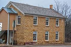
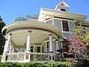
| 1 |
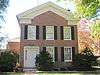
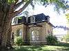
Judge John A. Bingham House |
|
000000001976-01-02-0000January 2, 1976
(#76000063) |
621 14th Ave.
42°36′21″N 89°38′31″W / 42.605833°N 89.641944°W / 42.605833; -89.641944 (Judge John A. Bingham House) |
Monroe |
|
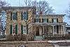
| 2 |
Gen. James Bintliff House |
|
000000001979-05-14-0000May 14, 1979
(#79000080) |
723 18th Ave.
42°36′17″N 89°38′15″W / 42.604722°N 89.6375°W / 42.604722; -89.6375 (Gen. James Bintliff House) |
Monroe |
|
| 3 |
Dr. Samuel Blumer House |
|
000000001992-11-05-0000November 5, 1992
(#92001556) |
112 Sixth Ave.
42°48′53″N 89°38′05″W / 42.814722°N 89.634722°W / 42.814722; -89.634722 (Dr. Samuel Blumer House) |
New Glarus |
|
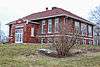
| 4 |
Cadiz Township Joint District No. 2 School |
|
000000001996-04-12-0000April 12, 1996
(#96000419) |
214 School St.
42°34′34″N 89°47′24″W / 42.576111°N 89.79°W / 42.576111; -89.79 (Cadiz Township Joint District No. 2 School) |
Browntown |
|
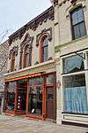
| 5 |
Caradine Building |
|
000000001979-05-08-0000May 8, 1979
(#79000081) |
1007 16th Ave.
42°36′07″N 89°38′24″W / 42.601944°N 89.64°W / 42.601944; -89.64 (Caradine Building) |
Monroe |
|
| 6 |
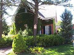
Chalet of the Golden Fleece |
Upload image |
000000002015-08-24-0000August 24, 2015
(#15000551) |
618 2nd St.
42°48′50″N 89°38′06″W / 42.813768°N 89.634875°W / 42.813768; -89.634875 (Chalet of the Golden Fleece) |
New Glarus |
|
| 7 |
Frank L. Chenoweth House |
|
000000001976-10-08-0000October 8, 1976
(#76000064) |
2004 10th St.
42°36′07″N 89°38′05″W / 42.601944°N 89.634722°W / 42.601944; -89.634722 (Frank L. Chenoweth House) |
Monroe |
|
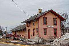
| 8 |
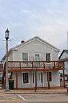
Chicago, Milwaukee and Saint Paul Railroad Depot |
|
000000002000-04-06-0000April 6, 2000
(#00000359) |
418 Railroad St.
42°49′00″N 89°37′57″W / 42.816667°N 89.6325°W / 42.816667; -89.6325 (Chicago, Milwaukee and Saint Paul Railroad Depot) |
New Glarus |
|
| 9 |
Cleveland's Hall and Blacksmith Shop |
|
000000002010-01-07-0000January 7, 2010
(#09001220) |
N7302 County Trunk Highway X
42°46′12″N 89°28′50″W / 42.770006°N 89.480675°W / 42.770006; -89.480675 (Cleveland's Hall and Blacksmith Shop) |
Brooklyn |
|
| 10 |
Exchange Square Historic District |
|
000000001984-11-15-0000November 15, 1984
(#84000724) |
Roughly bounded by 10th, RR tracks, E. 2nd and W. 3rd Aves.
42°37′11″N 89°22′37″W / 42.619722°N 89.376944°W / 42.619722; -89.376944 (Exchange Square Historic District) |
Brodhead |
|
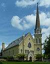
| 11 |
First Methodist Church |
|
000000001975-02-25-0000February 25, 1975
(#75000065) |
11th St. and 14th Ave.
42°36′06″N 89°38′34″W / 42.601667°N 89.642778°W / 42.601667; -89.642778 (First Methodist Church) |
Monroe |
Gothic revival design by E. Townsend Mix, 1869-87
|
| 12 |
Freitag Homestead |
|
000000002005-11-15-0000November 15, 2005
(#05001302) |
N7053 WI 69/39
42°45′35″N 89°36′58″W / 42.759722°N 89.616111°W / 42.759722; -89.616111 (Freitag Homestead) |
Washington |
|
| 13 |
Freitag's Pure Oil Service Station |
|
000000001980-01-15-0000January 15, 1980
(#80000139) |
1323 9th St.
42°36′11″N 89°38′28″W / 42.603056°N 89.641111°W / 42.603056; -89.641111 (Freitag's Pure Oil Service Station) |
Monroe |
|
| 14 |
Green County Courthouse |
|
000000001978-03-21-0000March 21, 1978
(#78000097) |
Courthouse Sq.
42°36′06″N 89°38′21″W / 42.601667°N 89.639167°W / 42.601667; -89.639167 (Green County Courthouse) |
Monroe |
1891, Richardsonian Romanesque style
|
| 15 |
Hefty-Blum Farmstead |
|
000000002000-06-02-0000June 2, 2000
(#00000601) |
W6303 Hefty Rd.
42°45′49″N 89°40′20″W / 42.763611°N 89.672222°W / 42.763611; -89.672222 (Hefty-Blum Farmstead) |
Washington |
|
| 16 |
C.D. Hulburt House |
|
000000001979-05-08-0000May 8, 1979
(#79000082) |
1205 13th Ave.
42°36′00″N 89°38′37″W / 42.6°N 89.643611°W / 42.6; -89.643611 (C.D. Hulburt House) |
Monroe |
|
| 17 |
Janet Jennings House |
|
000000001976-01-02-0000January 2, 1976
(#76000065) |
612 22nd Ave.
42°36′21″N 89°37′56″W / 42.605833°N 89.632222°W / 42.605833; -89.632222 (Janet Jennings House) |
Monroe |
|
| 18 |
Monroe Commercial District |
|
000000001982-05-06-0000May 6, 1982
(#82000671) |
Roughly bounded by 15th and 18th Aves., 9th and 13th Sts.
42°36′04″N 89°38′24″W / 42.601111°N 89.64°W / 42.601111; -89.64 (Monroe Commercial District) |
Monroe |
|
| 19 |
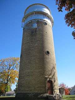
Monroe Water Tower |
|
000000002005-11-15-0000November 15, 2005
(#05001290) |
16th Ave. and 20th St.
42°35′43″N 89°38′23″W / 42.595278°N 89.639722°W / 42.595278; -89.639722 (Monroe Water Tower) |
Monroe |
|
| 20 |
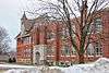
New Glarus Public School and High School |
|
000000001998-03-26-0000March 26, 1998
(#98000284) |
413 Sixth Ave.
42°48′51″N 89°38′17″W / 42.814167°N 89.638056°W / 42.814167; -89.638056 (New Glarus Public School and High School) |
New Glarus |
|
| 21 |
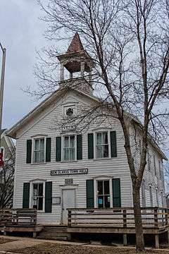
New Glarus Town Hall |
|
000000002008-04-11-0000April 11, 2008
(#08000286) |
206 2nd St.
42°49′05″N 89°38′06″W / 42.818058°N 89.635103°W / 42.818058; -89.635103 (New Glarus Town Hall) |
New Glarus |
|
| 22 |
Jacob Regez, Sr. House |
|
000000001980-01-17-0000January 17, 1980
(#80000140) |
2121 7th St.
42°36′19″N 89°37′56″W / 42.605278°N 89.632222°W / 42.605278; -89.632222 (Jacob Regez, Sr. House) |
Monroe |
|
| 23 |
Francis West Smith House |
|
000000001979-04-17-0000April 17, 1979
(#79000083) |
1002 W. 2nd Ave.
42°37′14″N 89°22′40″W / 42.620556°N 89.377778°W / 42.620556; -89.377778 (Francis West Smith House) |
Brodhead |
|
| 24 |
John C. and Barbara Steinman House |
|
000000002003-11-26-0000November 26, 2003
(#03001215) |
330 S. Monroe St.
42°44′34″N 89°35′42″W / 42.742778°N 89.595°W / 42.742778; -89.595 (John C. and Barbara Steinman House) |
Monticello |
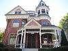
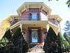
|
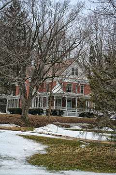
| 25 |
Gen. Francis H. West House |
|
000000001975-01-01-0000January 1, 1975
(#75000066) |
1410 17th Ave.
42°35′53″N 89°38′15″W / 42.598056°N 89.6375°W / 42.598056; -89.6375 (Gen. Francis H. West House) |
Monroe |
Octagon house designed by Orson Fowler, built of brick in 1860
|
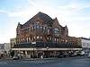
| 26 |
F. F. White Block |
|
000000001979-01-31-0000January 31, 1979
(#79000084) |
1514-1524 11th St.
42°36′03″N 89°38′23″W / 42.600833°N 89.639722°W / 42.600833; -89.639722 (F. F. White Block) |
Monroe |
|