| [3] |
Name on the Register |
Image |
Date listed[4] |
Location |
City or town |
Description |
|---|
| 1 |
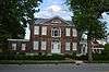
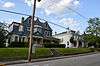
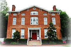
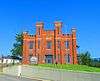
Col. R.T.P. Allen House |
Upload image |
000000001979-07-10-0000July 10, 1979
(#79000984) |
South of Frankfort on Johnson Rd.
38°10′14″N 84°51′40″W / 38.170556°N 84.861111°W / 38.170556; -84.861111 (Col. R.T.P. Allen House) |
Frankfort |
|
| 2 |
Archeological Site 15 Fr 26 |
Upload image |
000000001978-03-31-0000March 31, 1978
(#78001331) |
Address Restricted
|
Harvieland |
|
| 3 |
Archeological Site 15 Fr 34 |
Upload image |
000000001978-02-17-0000February 17, 1978
(#78001326) |
Address Restricted
|
Frankfort |
|
| 4 |
Archeological Site 15 Fr 52 |
Upload image |
000000001978-02-14-0000February 14, 1978
(#78001330) |
Address Restricted
|
Harvieland |
|
| 5 |
Archeological Site 15 FR 368 |
Upload image |
000000001985-09-12-0000September 12, 1985
(#85002370) |
Address Restricted
|
Frankfort |
Fort Hill, a Civil War fort[5]
|
| 6 |
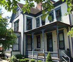
Arrowhead |
Upload image |
000000001989-09-28-0000September 28, 1989
(#89001597) |
U.S. Route 60, 0.5 miles (0.80 km) south of Hanley Ln.
38°10′44″N 84°49′10″W / 38.178889°N 84.819444°W / 38.178889; -84.819444 (Arrowhead) |
Frankfort |
|
| 7 |
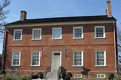
Beeches |
Upload image |
000000001979-02-09-0000February 9, 1979
(#79000985) |
Off U.S. Route 421
38°12′46″N 84°52′01″W / 38.212778°N 84.866944°W / 38.212778; -84.866944 (Beeches) |
Frankfort |
|
| 8 |
George F. Berry House |
|
000000002002-09-06-0000September 6, 2002
(#02000915) |
700 Louisville Rd.
38°11′15″N 84°52′57″W / 38.1875°N 84.8825°W / 38.1875; -84.8825 (George F. Berry House) |
Frankfort |
|
| 9 |
Blanton-Crutcher Farm |
Upload image |
000000001975-10-29-0000October 29, 1975
(#75000757) |
5 miles (8.0 km) southeast of Frankfort off U.S. Route 60
38°09′37″N 84°49′13″W / 38.160278°N 84.820278°W / 38.160278; -84.820278 (Blanton-Crutcher Farm) |
Frankfort |
|
| 10 |
Bridgeport School |
Upload image |
000000002014-01-08-0000January 8, 2014
(#13001049) |
555 Bridgeport Rd.
38°09′38″N 84°56′54″W / 38.160464°N 84.948252°W / 38.160464; -84.948252 (Bridgeport School) |
Bridgeport |
|
| 11 |
Brown-Henry House |
Upload image |
000000002014-01-08-0000January 8, 2014
(#13001050) |
818 Fields Ave.
38°12′42″N 84°51′24″W / 38.211763°N 84.856647°W / 38.211763; -84.856647 (Brown-Henry House) |
Frankfort |
|
| 12 |
Central Frankfort Historic District |
|
000000002009-07-28-0000July 28, 2009
(#09000570) |
Bounded by E. and W. 2nd St., Logan St., the Kentucky River, High St., and Mero St.
38°11′44″N 84°52′34″W / 38.195556°N 84.876111°W / 38.195556; -84.876111 (Central Frankfort Historic District) |
Frankfort |
|
| 13 |
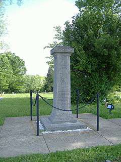
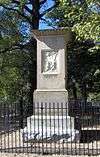
Colored Soldiers Monument in Frankfort |
|
000000001997-07-17-0000July 17, 1997
(#97000701) |
Greenhill Cemetery, 0.1 miles (0.16 km) southeast of the junction of E. Main St. and Myrtle Ave.
38°12′18″N 84°50′18″W / 38.205°N 84.838333°W / 38.205; -84.838333 (Colored Soldiers Monument in Frankfort) |
Frankfort |
|
| 14 |
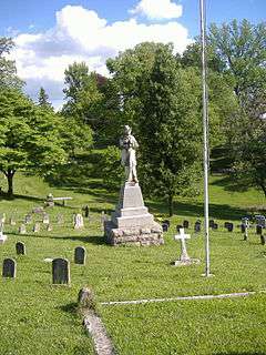
Confederate Monument in Frankfort |
|
000000001997-07-17-0000July 17, 1997
(#97000702) |
215 E. Main St.
38°11′48″N 84°52′05″W / 38.196667°N 84.868056°W / 38.196667; -84.868056 (Confederate Monument in Frankfort) |
Frankfort |
|
| 15 |
Corner in Celebrities Historic District |
|
000000001971-03-11-0000March 11, 1971
(#71000343) |
Roughly bounded by the Kentucky River on the south and the west, St. Clair and Main Sts.
38°11′57″N 84°52′46″W / 38.199167°N 84.879444°W / 38.199167; -84.879444 (Corner in Celebrities Historic District) |
Frankfort |
|
| 16 |
Dills Site |
Upload image |
000000001978-03-21-0000March 21, 1978
(#78001327) |
Address Restricted
|
Frankfort |
|
| 17 |
Frankfort Barracks District |
|
000000001975-11-20-0000November 20, 1975
(#75000758) |
Bounded by New, Shelby, and Coke Sts., and Woodland Ave.
38°11′19″N 84°52′38″W / 38.188611°N 84.877222°W / 38.188611; -84.877222 (Frankfort Barracks District) |
Frankfort |
|
| 18 |
Frankfort Cemetery and Chapel |
|
000000001974-07-12-0000July 12, 1974
(#74000872) |
215 E. Main St.
38°11′38″N 84°51′56″W / 38.193889°N 84.865556°W / 38.193889; -84.865556 (Frankfort Cemetery and Chapel) |
Frankfort |
|
| 19 |
Frankfort Commercial Historic District |
|
000000001979-05-10-0000May 10, 1979
(#79000986) |
Both sides of the Kentucky River at Bridge St.
38°11′54″N 84°52′39″W / 38.198333°N 84.877500°W / 38.198333; -84.877500 (Frankfort Commercial Historic District) |
Frankfort |
|
| 20 |
Frankfort Greenhouses |
Upload image |
000000001997-10-09-0000October 9, 1997
(#97000233) |
210, 212, and 216 E. Main St.
38°11′54″N 84°52′01″W / 38.198333°N 84.866944°W / 38.198333; -84.866944 (Frankfort Greenhouses) |
Frankfort |
|
| 21 |
Frankfort Storage Building-Armory |
Upload image |
000000002002-09-06-0000September 6, 2002
(#02000929) |
208 Maryland Ave.
38°11′48″N 84°51′31″W / 38.196667°N 84.858611°W / 38.196667; -84.858611 (Frankfort Storage Building-Armory) |
Frankfort |
|
| 22 |
Giltner-Holt House |
Upload image |
000000001978-05-05-0000May 5, 1978
(#78001328) |
5 miles (8.0 km) north of Frankfort
38°15′03″N 84°50′01″W / 38.250833°N 84.833611°W / 38.250833; -84.833611 (Giltner-Holt House) |
Frankfort |
|
| 23 |
Glen Willis |
|
000000001972-06-13-0000June 13, 1972
(#72000531) |
Leestown Pike
38°12′37″N 84°52′20″W / 38.210278°N 84.872222°W / 38.210278; -84.872222 (Glen Willis) |
Frankfort |
|
| 24 |
Gooch House |
|
000000001980-04-30-0000April 30, 1980
(#80001528) |
104 2nd St.
38°11′42″N 84°52′29″W / 38.195°N 84.874722°W / 38.195; -84.874722 (Gooch House) |
Frankfort |
|
| 25 |
Haggin Farm |
Upload image |
000000001983-06-23-0000June 23, 1983
(#83002773) |
KY 1685
38°11′24″N 84°44′25″W / 38.19°N 84.740278°W / 38.19; -84.740278 (Haggin Farm) |
Midway |
|
| 26 |
Andrew Hearn Log House and Farm |
|
000000001976-08-11-0000August 11, 1976
(#76000886) |
3 miles (4.8 km) southwest of Jett on Hanley Lane
38°09′26″N 84°50′08″W / 38.157222°N 84.835556°W / 38.157222; -84.835556 (Andrew Hearn Log House and Farm) |
Jett |
|
| 27 |
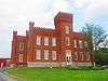
E.E. Hume Hall |
Upload image |
000000001983-05-26-0000May 26, 1983
(#83004050) |
Kentucky State University campus
38°12′07″N 84°51′21″W / 38.201944°N 84.855833°W / 38.201944; -84.855833 (E.E. Hume Hall) |
Frankfort |
|
| 28 |
Hutcherson Site |
Upload image |
000000001978-03-21-0000March 21, 1978
(#78001332) |
Address Restricted
|
Polsgrove |
|
| 29 |
Jackson Hall, Kentucky State University |
|
000000001973-04-11-0000April 11, 1973
(#73000802) |
E. Main St.
38°12′10″N 84°51′29″W / 38.202778°N 84.858056°W / 38.202778; -84.858056 (Jackson Hall, Kentucky State University) |
Frankfort |
|
| 30 |
Julian Farm |
Upload image |
000000001988-05-26-0000May 26, 1988
(#88000670) |
Southern side of U.S. Route 60
38°09′51″N 84°55′49″W / 38.164167°N 84.930278°W / 38.164167; -84.930278 (Julian Farm) |
Bridgeport |
|
| 31 |
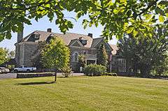
Kentucky Governor's Mansion |
|
000000001972-02-01-0000February 1, 1972
(#72000532) |
Eastern lawn of the Capitol at the end of Capital Ave.
38°11′14″N 84°52′25″W / 38.187222°N 84.873611°W / 38.187222; -84.873611 (Kentucky Governor's Mansion) |
Frankfort |
|
| 32 |
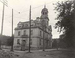
Kentucky State Arsenal |
|
000000001973-04-11-0000April 11, 1973
(#73000803) |
Main St. at Capital Ave.
38°11′51″N 84°52′22″W / 38.1975°N 84.872778°W / 38.1975; -84.872778 (Kentucky State Arsenal) |
Frankfort |
|
| 33 |
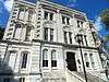
Kentucky State Capitol |
|
000000001973-04-13-0000April 13, 1973
(#73000804) |
Capitol grounds at end of Capital Ave.
38°11′12″N 84°52′33″W / 38.186667°N 84.875833°W / 38.186667; -84.875833 (Kentucky State Capitol) |
Frankfort |
|
| 34 |
Knight-Taylor-Hockensmith House |
Upload image |
000000002013-06-25-0000June 25, 2013
(#13000475) |
4350 Peaks Mill Road
38°16′10″N 84°48′49″W / 38.26933°N 84.81348°W / 38.26933; -84.81348 (Knight-Taylor-Hockensmith House) |
Frankfort |
|
| 35 |
Liberty Hall |
|
000000001971-11-11-0000November 11, 1971
(#71000344) |
218 Wilkinson St.
38°11′59″N 84°52′52″W / 38.199722°N 84.881111°W / 38.199722; -84.881111 (Liberty Hall) |
Frankfort |
|
| 36 |
Gov. Charles S. Morehead House |
|
000000001974-12-30-0000December 30, 1974
(#74000873) |
217 Shelby St.
38°11′39″N 84°52′33″W / 38.194167°N 84.875833°W / 38.194167; -84.875833 (Gov. Charles S. Morehead House) |
Frankfort |
|
| 37 |
Old Governor's Mansion |
|
000000001971-03-11-0000March 11, 1971
(#71000345) |
420 High St.
38°11′58″N 84°52′26″W / 38.199444°N 84.873889°W / 38.199444; -84.873889 (Old Governor's Mansion) |
Frankfort |
|
| 38 |
Old Statehouse |
|
000000001971-03-11-0000March 11, 1971
(#71000346) |
On Broadway, bounded by Madison, Clinton, and Lewis Sts.
38°12′01″N 84°52′36″W / 38.200278°N 84.876667°W / 38.200278; -84.876667 (Old Statehouse) |
Frankfort |
|
| 39 |
Old Statehouse Historic District |
|
000000001980-06-19-0000June 19, 1980
(#80001529) |
Roughly bounded by Broadway, Blanton, St. Clair, Ann, and High Sts.
38°12′02″N 84°52′29″W / 38.200556°N 84.874722°W / 38.200556; -84.874722 (Old Statehouse Historic District) |
Frankfort |
|
| 40 |
Old Stone Tavern |
Upload image |
000000001983-06-23-0000June 23, 1983
(#83002774) |
Scruggs Lane and Leestown Pike
38°11′16″N 84°48′02″W / 38.187778°N 84.800556°W / 38.187778; -84.800556 (Old Stone Tavern) |
Frankfort |
|
| 41 |
Old U.S. Courthouse and Post Office |
|
000000001974-07-03-0000July 3, 1974
(#74000874) |
305 Wapping St.
38°11′51″N 84°52′45″W / 38.197500°N 84.879167°W / 38.197500; -84.879167 (Old U.S. Courthouse and Post Office) |
Frankfort |
|
| 42 |
Charles Patterson House |
Upload image |
000000001983-06-23-0000June 23, 1983
(#83002775) |
KY 1689
38°14′00″N 84°46′33″W / 38.233333°N 84.775833°W / 38.233333; -84.775833 (Charles Patterson House) |
Frankfort |
|
| 43 |
Penn-Marshall Stone House |
Upload image |
000000001975-06-05-0000June 5, 1975
(#75000760) |
East of Harvieland on Stoney Creek Rd. at the Kentucky River
38°15′28″N 84°53′43″W / 38.257778°N 84.895278°W / 38.257778; -84.895278 (Penn-Marshall Stone House) |
Harvieland |
|
| 44 |
Point Breeze |
Upload image |
000000002014-01-08-0000January 8, 2014
(#13001051) |
219 Riverview St.
38°11′00″N 84°52′41″W / 38.183418°N 84.8781°W / 38.183418; -84.8781 (Point Breeze) |
Frankfort |
|
| 45 |
Risk Brothers Site |
Upload image |
000000001978-11-21-0000November 21, 1978
(#78001329) |
Address Restricted
|
Frankfort |
|
| 46 |
Scotland |
Upload image |
000000001976-12-12-0000December 12, 1976
(#76000883) |
5 miles (8.0 km) east of Frankfort on Versailles Rd.
38°10′16″N 84°48′12″W / 38.171111°N 84.803333°W / 38.171111; -84.803333 (Scotland) |
Frankfort |
|
| 47 |
South Frankfort Neighborhood Historic District |
|
000000001982-08-19-0000August 19, 1982
(#82002698) |
Roughly bounded by U.S. Route 60, Rockland Ct., and the Kentucky River; also roughly bounded by U.S. Route 60, Taylor Ave., the Kentucky River, and the Tanglewood subdivision
38°11′28″N 84°52′33″W / 38.191111°N 84.875833°W / 38.191111; -84.875833 (South Frankfort Neighborhood Historic District) |
Frankfort |
Second set of boundaries represents a boundary increase of 000000002013-07-30-0000July 30, 2013
|
| 48 |
George T. Stagg Distillery |
|
000000002001-05-02-0000May 2, 2001
(#01000450) |
1001 Wilkinson Boulevard
38°12′59″N 84°52′09″W / 38.216389°N 84.869167°W / 38.216389; -84.869167 (George T. Stagg Distillery) |
Frankfort |
Designated a National Historic Landmark on February 27, 2013[6]
|
| 49 |
Stewart Home School |
Upload image |
000000001976-06-03-0000June 3, 1976
(#76000884) |
5.5 miles (8.9 km) south of Frankfort on U.S. Route 127
38°07′35″N 84°54′28″W / 38.126389°N 84.907778°W / 38.126389; -84.907778 (Stewart Home School) |
Frankfort |
|
| 50 |
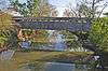
Switzer Covered Bridge |
|
000000001974-09-06-0000September 6, 1974
(#74000875) |
Off Rocky Branch Rd., over North Elkhorn Creek
38°15′14″N 84°45′08″W / 38.253889°N 84.752222°W / 38.253889; -84.752222 (Switzer Covered Bridge) |
Switzer |
|
| 51 |
Robert Todd Summer Home |
Upload image |
000000001983-06-23-0000June 23, 1983
(#83002776) |
U.S. Route 421
38°10′50″N 84°47′13″W / 38.180556°N 84.786944°W / 38.180556; -84.786944 (Robert Todd Summer Home) |
Frankfort |
|
| 52 |
Andrew Trumbo Log House |
Upload image |
000000001977-11-17-0000November 17, 1977
(#77000618) |
East of Frankfort on Glenns Creek Rd.
38°10′29″N 84°50′53″W / 38.174722°N 84.848056°W / 38.174722; -84.848056 (Andrew Trumbo Log House) |
Frankfort |
|
| 53 |
Valley Farm Ruins |
Upload image |
000000001975-07-24-0000July 24, 1975
(#75000759) |
Address Restricted
|
Frankfort |
|
| 54 |
Weehawken |
Upload image |
000000002007-04-24-0000April 24, 2007
(#07000283) |
1 Weehawken Ln.
38°11′44″N 84°49′20″W / 38.195556°N 84.822222°W / 38.195556; -84.822222 (Weehawken) |
Jett |
|
| 55 |
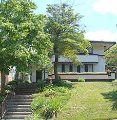
Rev. Jesse R. Zeigler House |
|
000000001976-05-03-0000May 3, 1976
(#76000885) |
509 Shelby St.
38°11′25″N 84°52′35″W / 38.190278°N 84.876389°W / 38.190278; -84.876389 (Rev. Jesse R. Zeigler House) |
Frankfort |
|


.jpg)