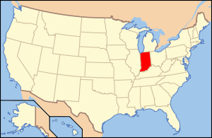
National Register of Historic Places listings in Franklin County, Indiana
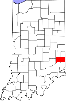
Location of Franklin County in Indiana
This is a list of the National Register of Historic Places listings in Franklin County, Indiana.
This is intended to be a complete list of the properties and districts on the National Register of Historic Places in Franklin County, Indiana, United States. Latitude and longitude coordinates are provided for many National Register properties and districts; these locations may be seen together in a map.[1]
There are 14 properties and districts listed on the National Register in the county, including 1 National Historic Landmark.
Properties and districts located in incorporated areas display the name of the municipality, while properties and districts in unincorporated areas display the name of their civil township. Properties and districts split between multiple jurisdictions display the names of all jurisdictions.
- This National Park Service list is complete through NPS recent listings posted December 16, 2016.[2]
Current listings
| [3] |
Name on the Register[4] |
Image |
Date listed[5] |
Location |
City or town |
Description |
|---|
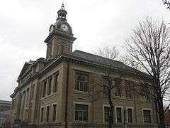
| 1 |
Brookville Historic District |
|
000000001975-07-25-0000July 25, 1975
(#75000018) |
Bounded by the east and west forks of the Whitewater River and State Road 101
39°25′22″N 85°00′35″W / 39.422778°N 85.009722°W / 39.422778; -85.009722 (Brookville Historic District) |
Brookville |
|
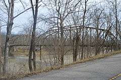
| 2 |
Cedar Grove Bridge |
|
000000002014-09-30-0000September 30, 2014
(#14000801) |
Old State Road 1 over the Whitewater River
39°21′12″N 84°56′35″W / 39.353333°N 84.942944°W / 39.353333; -84.942944 (Cedar Grove Bridge) |
Cedar Grove and Highland Township |
|
| 3 |
Duck Creek Aqueduct |
|
000000002014-08-25-0000August 25, 2014
(#14000922) |
Spanning Duck Creek at the Whitewater Canal
39°26′46″N 85°07′48″W / 39.446111°N 85.130000°W / 39.446111; -85.130000 (Duck Creek Aqueduct) |
Metamora Township |
|
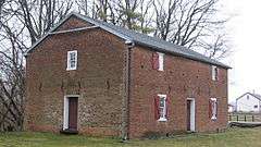
| 4 |
Franklin County Seminary |
|
000000001974-03-28-0000March 28, 1974
(#74000020) |
412 5th St.
39°25′10″N 85°00′31″W / 39.419444°N 85.008611°W / 39.419444; -85.008611 (Franklin County Seminary) |
Brookville |
|
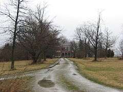
| 5 |
The Hermitage |
|
000000002004-03-22-0000March 22, 2004
(#04000209) |
650 E. 8th St.
39°25′25″N 85°00′17″W / 39.423611°N 85.004722°W / 39.423611; -85.004722 (The Hermitage) |
Brookville |
|
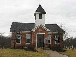
| 6 |
Little Cedar Grove Baptist Church |
|
000000001990-03-22-0000March 22, 1990
(#90000366) |
U.S. Route 52 at Little Cedar Rd., southeast of Brookville
39°23′14″N 84°58′53″W / 39.387222°N 84.981389°W / 39.387222; -84.981389 (Little Cedar Grove Baptist Church) |
Brookville Township |
|
| 7 |
Metamora Historic District |
|
000000001992-12-07-0000December 7, 1992
(#92001646) |
Roughly bounded by U.S. Route 52, Columbia St., the Whitewater Canal, Duck Creek, Mount St., and Main St., at Metamora
39°26′49″N 85°08′01″W / 39.446944°N 85.133611°W / 39.446944; -85.133611 (Metamora Historic District) |
Metamora |
|
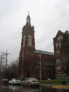
| 8 |
Oldenburg Historic District |
|
000000001983-03-03-0000March 3, 1983
(#83000031) |
Bounded roughly by Sycamore, church land woods, Indiana and Water Sts., and Gehring Farm
39°20′27″N 85°12′09″W / 39.340833°N 85.2025°W / 39.340833; -85.2025 (Oldenburg Historic District) |
Oldenburg and Ray Township |
|
| 9 |
Old Franklin United Brethren Church |
|
000000001995-03-03-0000March 3, 1995
(#95000201) |
Junction of Franklin Church Rd. and State Road 101, 0.5 miles north of Fox Run Rd. and northeast of Brookville
39°30′22″N 84°56′56″W / 39.506111°N 84.948889°W / 39.506111; -84.948889 (Old Franklin United Brethren Church) |
Fairfield Township |
|
| 10 |
Joseph Shafer Farm |
|
000000001982-08-26-0000August 26, 1982
(#82000038) |
Northeast of Brookville on Flinn Road
39°28′26″N 84°52′46″W / 39.473889°N 84.879444°W / 39.473889; -84.879444 (Joseph Shafer Farm) |
Springfield Township |
|
| 11 |
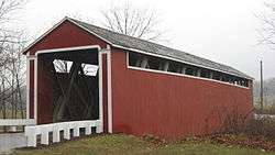
Snow Hill Covered Bridge |
|
000000001995-03-03-0000March 3, 1995
(#95000208) |
Snow Hill Rd. over Johnson Fork, north of Rockdale
39°19′32″N 84°51′06″W / 39.325556°N 84.851667°W / 39.325556; -84.851667 (Snow Hill Covered Bridge) |
Whitewater Township |
|
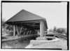
| 12 |
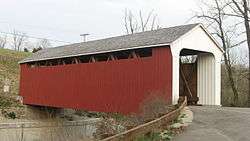
Stockheughter Covered Bridge |
|
000000002002-03-20-0000March 20, 2002
(#02000198) |
27046 Enochsburg Rd., northwest of Batesville
39°20′01″N 85°16′52″W / 39.333611°N 85.281111°W / 39.333611; -85.281111 (Stockheughter Covered Bridge) |
Ray Township |
|
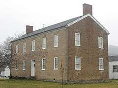
| 13 |
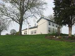
Salmon Turrell Farmstead |
|
000000002009-06-17-0000June 17, 2009
(#09000423) |
3051 Snow Hill Rd., northwest of West Harrison
39°19′40″N 84°51′37″W / 39.327778°N 84.860278°W / 39.327778; -84.860278 (Salmon Turrell Farmstead) |
Whitewater Township |
|
| 14 |
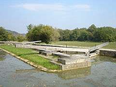
Whitewater Canal Historic District |
|
000000001973-06-13-0000June 13, 1973
(#73000272) |
From the Laurel Feeder Dam to Brookville
39°27′33″N 85°06′34″W / 39.459167°N 85.109444°W / 39.459167; -85.109444 (Whitewater Canal Historic District) |
Brookville and Brookville, Laurel, and Metamora Townships |
|
See also
References
- ↑ The latitude and longitude information provided in this table was derived originally from the National Register Information System, which has been found to be fairly accurate for about 99% of listings. For about 1% of NRIS original coordinates, experience has shown that one or both coordinates are typos or otherwise extremely far off; some corrections may have been made. A more subtle problem causes many locations to be off by up to 150 yards, depending on location in the country: most NRIS coordinates were derived from tracing out latitude and longitudes off of USGS topographical quadrant maps created under the North American Datum of 1927, which differs from the current, highly accurate WGS84 GPS system used by most on-line maps. Chicago is about right, but NRIS longitudes in Washington are higher by about 4.5 seconds, and are lower by about 2.0 seconds in Maine. Latitudes differ by about 1.0 second in Florida. Some locations in this table may have been corrected to current GPS standards.
- ↑ "National Register of Historic Places: Weekly List Actions". National Park Service, United States Department of the Interior. Retrieved on December 16, 2016.
- ↑ Numbers represent an ordering by significant words. Various colorings, defined here, differentiate National Historic Landmarks and historic districts from other NRHP buildings, structures, sites or objects.
- ↑ National Park Service (2009-03-13). "National Register Information System". National Register of Historic Places. National Park Service.
- ↑ The eight-digit number below each date is the number assigned to each location in the National Register Information System database, which can be viewed by clicking the number.
|
|---|
|
| Topics | |
|---|
|
| Lists by states | |
|---|
|
| Lists by insular areas | |
|---|
|
| Lists by associated states | |
|---|
|
| Other areas | |
|---|
|
-
 Portal Portal
-
 WikiProject WikiProject
|
|
|---|
|
| Topics | | |
|---|
|
Lists
by county | |
|---|
|
| Other lists | |
|---|
|
|