National Register of Historic Places listings in eastern Puerto Rico
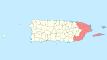
National Register entries listed below are found in the highlighted 16 municipalities of Puerto Rico.
This portion of National Register of Historic Places listings in Puerto Rico covers the eastern region of Puerto Rico, from Carolina in the northeast to Arroyo in the southeast. It also includes the islands of Culebra and Vieques.
See also:
- National Register of Historic Places listings in southern Puerto Rico
- National Register of Historic Places listings in northern Puerto Rico
- National Register of Historic Places listings in western Puerto Rico
- National Register of Historic Places listings in central Puerto Rico
- National Register of Historic Places listings in San Juan, Puerto Rico
Names of places given are as appear in the National Register, reflecting name as given in NRHP application at the date of listing. Note, the National Register name system does not accommodate Spanish á, ñ and other letters.
- This National Park Service list is complete through NPS recent listings posted December 2, 2016.[1]
Arroyo
| [2] | Name on the Register | Image | Date listed[3] | Location | Barrio | Description |
|---|---|---|---|---|---|---|
| 1 | Faro de Punta de las Figuras | 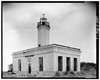 |
(#81000687) |
On Punta de las Figuras, southeast of Arroyo Pueblo 17°57′18″N 66°02′52″W / 17.954976°N 66.047657°W |
Palmas |
Canóvanas
| [2] | Name on the Register | Image | Date listed[3] | Location | Barrio | Description |
|---|---|---|---|---|---|---|
| 1 | Villarán Bridge | 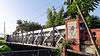 |
(#95000835) |
Highway 9959, km 3, spanning Río Canóvanas 18°22′45″N 65°53′32″W / 18.379213°N 65.892087°W |
Canóvanas Pueblo and Canóvanas | Built in 1892 on the 19th century highway between Río Piedras and Río Grande, this iron and masonry bridge is the best preserved example of an Eiffel pony truss bridge in Puerto Rico or the United States. By 1994, it had been replaced by an adjacent span for vehicular use, but it remained open for pedestrian use.[4] |
Carolina
| [2] | Name on the Register | Image | Date listed[3] | Location | Barrio | Description |
|---|---|---|---|---|---|---|
| 1 | Church San Fernando of Carolina | 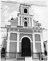 |
(#84003160) |
Muñoz Rivera St., Town Plaza 18°22′52″N 65°57′23″W / 18.381072°N 65.956317°W |
Carolina Pueblo | Church from 1860 |
| 2 | Edificio Alcaldia | Upload image | (#83004197) |
Sánchez Osorio St. at José de Diego St. 18°22′53″N 65°57′27″W / 18.381253°N 65.957427°W |
Carolina Pueblo | From 1927, designed by Rafael Carmoega |
| 3 | Quebrada Maracuto | Upload image | (#04000909) |
Address restricted[lower-alpha 1][5] |
Cacao and Santa Cruz[6] |
Ceiba
| [2] | Name on the Register | Image | Date listed[3] | Location | Barrio | Description |
|---|---|---|---|---|---|---|
| 1 | Ceiba Fire Station | Upload image | (#13000012) |
226 Lauro Piñero Avenue 18°15′59″N 65°38′52″W / 18.266333°N 65.647698°W |
Ceiba Pueblo |
Culebra
| [2] | Name on the Register | Image | Date listed[3] | Location | Barrio | Description |
|---|---|---|---|---|---|---|
| 1 | Faro Isla de Culebritas |  |
(#81000686) |
Isla Culebrita 18°18′49″N 65°13′39″W / 18.313694°N 65.227444°W |
Fraile |
Fajardo
| [2] | Name on the Register | Image | Date listed[3] | Location | Barrio | Description |
|---|---|---|---|---|---|---|
| 1 | Church Santiago Apóstol of Fajardo | .jpg) |
(#84003144) |
Town Plaza 18°19′30″N 65°39′11″W / 18.324873°N 65.653066°W |
Fajardo Pueblo | A church from 1776 |
| 2 | Faro de las Cabezas de San Juan | 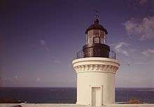 |
(#81000692) |
Northeast of Soroco 18°22′53″N 65°37′05″W / 18.381457°N 65.618134°W |
Cabezas | |
| 3 | U.S. Custom House | Upload image | (#88000077) |
Union Street 18°20′02″N 65°37′50″W / 18.333942°N 65.630564°W |
Fajardo Pueblo | From 1930, designed by Albert B. Nichols |
Humacao
| [2] | Name on the Register | Image | Date listed[3] | Location | Barrio | Description |
|---|---|---|---|---|---|---|
| 1 | Casa Roig | 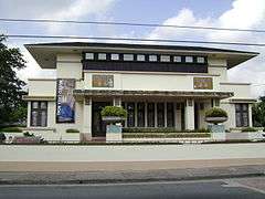 |
(#77001550) |
66 Antonio López Street 18°08′53″N 65°49′30″W / 18.147971°N 65.824867°W |
Humacao Pueblo | A Prairie School building from 1920 |
| 2 | Church Dulce Nombre de Jesús of Humacao | 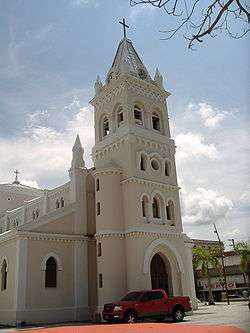 |
(#84003140) |
Town Plaza 18°09′01″N 65°49′34″W / 18.150157°N 65.826199°W |
Humacao Pueblo | Late Gothic Revival church from 1869 |
| 3 | Guzmán Family Pantheon | 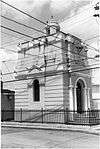 |
(#95000436) |
Junction of Padre Rivera and Miguel Casillas Streets 18°09′08″N 65°49′40″W / 18.152327°N 65.827904°W |
Humacao Pueblo | Eclectic style pantheon from 1864 |
| 4 | Humacao Customs House | 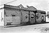 |
(#95000599) |
Junction of Marina and Aduana Streets 18°09′54″N 65°44′38″W / 18.164909°N 65.743989°W |
Punta Santiago | Spanish Colonial building from 1872, designed by Julian Cruellas y Rovira |
| 5 | Humacao District Courthouse | 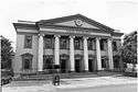 |
(#95000596) |
Junction of Dr. Vidal and Antonio López Streets 18°08′58″N 65°49′27″W / 18.149531°N 65.824152°W |
Humacao Pueblo | Classical Revival style courthouse from 1925, the Casa Alcaldía de Humacao |
| 6 | Palmira López de Pereyó House | Upload image | (#95000435) |
Junction of Font Martelo and Minerva Streets 18°09′02″N 65°49′20″W / 18.150545°N 65.822218°W |
Humacao Pueblo | Prairie School house from 1930 designed by Francisco Valines Cofresi |
| 7 | Antonia Sáez School | Upload image | (#95000597) |
Junction of Font Martelo and Isidro Ortiz Sreets 18°09′06″N 65°49′49″W / 18.151750°N 65.830288°W |
Humacao Pueblo | A Mission/Spanish Revival school from 1922 |
Las Piedras
| [2] | Name on the Register | Image | Date listed[3] | Location | Barrio | Description |
|---|---|---|---|---|---|---|
| 1 | Cueva del Indio | Upload image | (#03000884) |
Approximately 1.2 km (0.75 mi) north of Highway 198 18°11′50″N 65°52′24″W / 18.1972°N 65.8733°W |
Quebrada Arenas |
Loíza
| [2] | Name on the Register | Image | Date listed[3] | Location | Barrio | Description |
|---|---|---|---|---|---|---|
| 1 | Cueva de Los Indios | Upload image | (#82003823) |
Address restricted[lower-alpha 1][5] |
Torrecilla Baja | |
| 2 | Parroquia del Espiritu Santo y San Patricio[lower-alpha 2] | 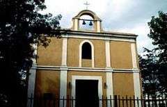 |
(#76002251) |
Plaza de Loíza 18°26′00″N 65°52′47″W / 18.433238°N 65.879610°W |
Loíza Pueblo | Dates from 1729[7] |
Luquillo
| [2] | Name on the Register | Image | Date listed[3] | Location | Barrio | Description |
|---|---|---|---|---|---|---|
| 1 | Williams Products Corporation | Upload image | (#12000938) |
Highway 992, km 0.3 18°22′16″N 65°43′07″W / 18.370986°N 65.718615°W |
Mata de Plátano |
Maunabo
| [2] | Name on the Register | Image | Date listed[3] | Location | Barrio | Description |
|---|---|---|---|---|---|---|
| 1 | Faro de Punta de la Tuna | 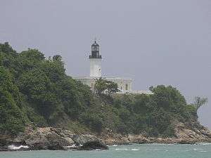 |
(#81000688) |
Southeast of Puerto Maunabo 17°59′18″N 65°53′07″W / 17.988370°N 65.885274°W |
Emajagua |
Naguabo
| [2] | Name on the Register | Image | Date listed[3] | Location | Barrio | Description |
|---|---|---|---|---|---|---|
| 1 | Bridge No. 122 | 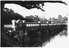 |
(#95000836) |
Highway 3, km 9, spanning the Santiago River 18°11′18″N 65°43′30″W / 18.188386°N 65.725108°W |
Río and Húcares | |
| 2 | Church Nuestra Señora del Rosario of Naguabo | 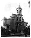 |
(#84000456) |
Town Plaza 18°12′43″N 65°44′09″W / 18.212062°N 65.735754°W |
Naguabo Pueblo | 1856 Spanish Colonial style building designed by Mariano Bosch |
| 3 | Icacos Petroglyph Group | Upload image | (#15000855) |
Address restricted[lower-alpha 1][5] |
Address restricted[lower-alpha 1][5] | |
| 4 | Villa Del Mar | Upload image | (#83002293) |
Highway 3, km 66.2 18°11′21″N 65°42′54″W / 18.189168°N 65.714985°W |
Húcares | 1917 building also known as "El Castillo" |
Patillas
| [2] | Name on the Register | Image | Date listed[3] | Location | Barrio | Description |
|---|---|---|---|---|---|---|
| 1 | María Dávila Semidey School | Upload image | (#12000939) |
300 Muñoz Rivera Street 18°00′21″N 66°01′01″W / 18.005906°N 66.017068°W |
Patillas Pueblo |
Río Grande
| [2] | Name on the Register | Image | Date listed[3] | Location | Barrio | Description |
|---|---|---|---|---|---|---|
| 1 | Río Grande Fire Station | Upload image | (#12001248) |
6 Juan R. González Street at Del Carmen Street 18°22′46″N 65°49′49″W / 18.379540°N 65.830289°W |
Río Grande Pueblo |
Vieques
| [2] | Name on the Register | Image | Date listed[3] | Location | Barrio | Description |
|---|---|---|---|---|---|---|
| 1 | Rafael Acevedo House | Upload image | (#94000249) |
Víctor Duteil Street between San José and Baldorioty Streets 18°09′00″N 65°26′35″W / 18.149938°N 65.443051°W |
Isabel Segunda | House built in Vieques Creole / Neoclasico style in 1900 |
| 2 | Algodones 2 (12VPr2-204) | Upload image | (#91001037) |
Address restricted[lower-alpha 1][5] |
Puerto Diablo | A village site, an archeological site |
| 3 | Algodones 3 (12VPr2-205) | Upload image | (#91001038) |
Address restricted[lower-alpha 1][5] |
Puerto Diablo | Another village site, an archeological site |
| 4 | Algodones 6 (12VPr2-229) | Upload image | (#91001032) |
Address restricted[lower-alpha 1][5] |
Puerto Diablo | Another village site, an archeological site |
| 5 | Camp Garcia (Campo Asilo) 3 (12VPr2-164) | Upload image | (#91001041) |
Address restricted[lower-alpha 1][5] |
Puerto Ferro | Site of petroglyphs |
| 6 | Casa Alcaldía de Vieques | 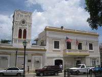 |
(#94000174) |
Junction of Carlos LeBrun and Benítez Guzmán Streets 18°08′59″N 65°26′30″W / 18.149654°N 65.441606°W |
Isabel Segunda | Town hall, from 1850 |
| 7 | Casa Augusto Delerme | Upload image | (#93001555) |
7 Benítez Guzmán Street 18°09′00″N 65°26′31″W / 18.150084°N 65.441849°W |
Isabel Segunda | A "4-Room Creole House", from 1850 |
| 8 | Casa Delerme-Anduze No. 2 | Upload image | (#93001205) |
355 Antonio Mellado Street 18°08′55″N 65°26′29″W / 18.148710°N 65.441300°W |
Isabel Segunda | A "six-room Creole house" from 1876 |
| 9 | Casa de Jaime Puig Lemoine | Upload image | (#94000363) |
161 65 de Infantería Street 18°08′55″N 65°26′35″W / 18.148680°N 65.442993°W |
Isabel Segunda | Bungalow/Craftsman house from 1930, designed by Jaime Puig |
| 10 | Central Playa Grande | Upload image | (#92001236) |
Address restricted[lower-alpha 1][5] |
Llave | A site with architecture by Matias Hjardemaal and others |
| 11 | Delerme-Anduze House | Upload image | (#93001556) |
361 Antonio Mellado Street 18°08′55″N 65°26′29″W / 18.148601°N 65.441414°W |
Isabel Segunda | A Creole gallery house |
| 12 | Faro de Vieques | .jpg) |
(#77001551) |
Punta Mulas 18°09′16″N 65°26′38″W / 18.1545°N 65.4438°W |
Puerto Diablo | Lighthouse built in 1896 |
| 13 | Fuerte de Vieques | 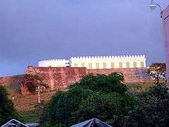 |
(#77001552) |
Calle del Fuerte 18°08′51″N 65°26′21″W / 18.147436°N 65.439070°W |
Isabel Segunda | Fort built in 1845 which now houses the Vieques Museum of Art and History |
| 14 | Hacienda Casa del Francés | Upload image | (#77001548) |
Near Esperanza 18°06′09″N 65°28′15″W / 18.102381°N 65.470786°W |
Puerto Real | Plantation architecture from 1910. Destroyed by fire in 2005.[9] |
| 15 | Laguna Jalova Archeological District | Upload image | (#92001237) |
Address restricted[lower-alpha 1][5] |
Puerto Diablo | Also known as "Western Friendly Front Line" |
| 16 | Llave 13 (12VPr2-175) | Upload image | (#91001036) |
Address restricted[lower-alpha 1][5] |
Llave | |
| 17 | Loma Jalova 3 (12VPr2-219) | Upload image | (#91001034) |
Address restricted[lower-alpha 1][5] |
Puerto Diablo | |
| 18 | Monte Largo 2 (12VPr2-172) | Upload image | (#91001042) |
Address restricted[lower-alpha 1][5] |
Puerto Diablo | |
| 19 | Paramayon 2 | Upload image | (#92001241) |
Address restricted[lower-alpha 1][5] |
Llave | |
| 20 | Le Pistolet (12VPr2-168) | Upload image | (#91001040) |
Address restricted[lower-alpha 1][5] |
Punta Arenas | |
| 21 | Playa Grande 9 (12VPr2-212) | Upload image | (#91001035) |
Address restricted[lower-alpha 1][5] |
Llave | |
| 22 | Playa Vieja | Upload image | (#92001235) |
Address restricted[lower-alpha 1][5] |
Punta Arenas | |
| 23 | Punta Jalova | Upload image | (#92001239) |
Address restricted[lower-alpha 1][5] |
Puerto Diablo | |
| 24 | Resolucion Historic District[lower-alpha 3] | Upload image | (#92001242) |
Address restricted[lower-alpha 1][5] |
Punta Arenas | Work designed by T. J. J. M. Le Guillou and others[10] |
| 25 | Smaine–Ortiz House | Upload image | (#93001554) |
341 Antonio Mellado Street 18°08′49″N 65°26′29″W / 18.146970°N 65.441358°W |
Isabel Segunda | |
| 26 | Las Tumbas de J. J. María le Guillou | Upload image | (#94000923) |
Highway 200, near Isabel Segunda 18°09′10″N 65°25′57″W / 18.152750°N 65.432444°W |
Puerto Diablo | Classical Revival style, from 1843 |
| 27 | Ventana Archeological District | Upload image | (#92001238) |
Address restricted[lower-alpha 1][5] |
Llave | |
| 28 | Ventana 4 (12VPr2-171) | Upload image | (#91001039) |
Address restricted[lower-alpha 1][5] |
Punta Arenas | |
| 29 | Vieques Pharmacy | Upload image | (#94000061) |
Junction of Carlos LeBrun and Víctor Duteil Streets 18°08′58″N 65°26′30″W / 18.149341°N 65.441751°W |
Isabel Segunda | |
| 30 | Yanuel 8 (12VPr2-173) | Upload image | (#91001043) |
Address restricted[lower-alpha 1][5] |
Puerto Diablo | |
| 31 | Yanuel 9 (12VPr2-220) | Upload image | (#91001033) |
Address restricted[lower-alpha 1][5] |
Puerto Diablo |
Yabucoa
| [2] | Name on the Register | Image | Date listed[3] | Location | Barrio | Description |
|---|---|---|---|---|---|---|
| 1 | Yabucoa Fire Station | Upload image | (#13000015) |
22 Luis Muñoz Rivera Street 18°03′07″N 65°52′38″W / 18.051979°N 65.877330°W |
Yabucoa Pueblo |
See also
- National Register of Historic Places listings in Puerto Rico
- Historic preservation
- History of Puerto Rico
Notes
- 1 2 3 4 5 6 7 8 9 10 11 12 13 14 15 16 17 18 19 20 21 22 23 Federal and state laws and practices restrict general public access to information regarding the specific location of sensitive archaeological sites in many instances. The main reasons for such restrictions include the potential for looting, vandalism, or trampling.
- ↑ The name of the Parroquia del Espiritu Santo y San Patricio is presented here without the accent on "Espíritu" in conformance with the usage in the church's National Register nomination form[7] and Federal Register announcement of listing.[8]
- ↑ The name of the Resolucion Historic District is presented here without the accent on "Resolución" in conformance with the usage in the site's National Register nomination form[10] and announcement of listing.[11]
References
- ↑ "National Register of Historic Places: Weekly List Actions". National Park Service, United States Department of the Interior. Retrieved on December 2, 2016.
- 1 2 3 4 5 6 7 8 9 10 11 12 13 14 15 16 Numbers represent an ordering by significant words. Various colorings, defined here, differentiate National Historic Landmarks and historic districts from other NRHP buildings, structures, sites or objects.
- 1 2 3 4 5 6 7 8 9 10 11 12 13 14 15 16 The eight-digit number below each date is the number assigned to each location in the National Register Information System database, which can be viewed by clicking the number.
- ↑ Pumarada O'Neill, Luis (July 31, 1994), National Register of Historic Places Registration Form: Villarán Bridge (PDF), retrieved January 3, 2016.
- 1 2 3 4 5 6 7 8 9 10 11 12 13 14 15 16 17 18 19 20 21 22 23 Knoerl, John; Miller, Diane; Shrimpton, Rebecca H. (1990), Guidelines for Restricting Information about Historic and Prehistoric Resources, National Register Bulletin (29), National Park Service, U.S. Department of the Interior, OCLC 20706997.
- ↑ Oficina Estatal de Conservación Histórica (April 1, 2014), Quebrada Maracuto (PDF) (summary sheet), retrieved March 10, 2016.
- 1 2 Tarr, Jashina Alexandra (July 12, 1976), National Register of Historic Places Inventory — Nomination Form: Parroquia del Espiritu Santo y San Patricio (PDF), retrieved January 7, 2016.
- ↑ "Department of the Interior, Heritage Conservation and Recreation Service: National Register of Historic Places; Annual Listing of Historic Properties", 44 FR 7416 (February 6, 1979), at p. 7581.
- ↑ Fundación Puertorriqueña de las Humanidades (January 4, 2010), "Vieques: Casa del Francés Estate", Puerto Rico Encyclopedia, archived from the original on May 12, 2015, retrieved January 12, 2016.
- 1 2 Vescelius, Gary S. (July 5, 1980), National Register of Historic Places Registration Form: Resolucion Historic District (redacted PDF), retrieved January 13, 2016.
- ↑ National Park Service (September 25, 1992), Weekly List of Actions Taken on Properties: 9/14/92 through 9/19/92 (PDF), retrieved January 13, 2016.
External links
- Puerto Rico State Historic Preservation Office, National Register of Historic Places site
- National Park Service, National Register of Historic Places site
 Media related to National Register of Historic Places in Puerto Rico at Wikimedia Commons
This article is issued from Wikipedia - version of the 5/30/2016. The text is available under the Creative Commons Attribution/Share Alike but additional terms may apply for the media files.