| [2] |
Name on the Register |
Image |
Date listed[3] |
Location |
City or town |
Description |
|---|
| 1 |
Carson Valley Hospital |
Upload image |
000000001979-05-29-0000May 29, 1979
(#79001462) |
1466 U.S. Route 395
38°56′34″N 119°45′02″W / 38.942778°N 119.750556°W / 38.942778; -119.750556 (Carson Valley Hospital) |
Gardnerville |
|
| 2 |
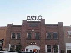
Carson Valley Improvement Club Hall |
|
000000001983-08-04-0000August 4, 1983
(#83004184) |
1606 Esmeralda Ave.
38°57′12″N 119°45′49″W / 38.953333°N 119.763611°W / 38.953333; -119.763611 (Carson Valley Improvement Club Hall) |
Minden |
|
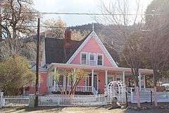
| 3 |
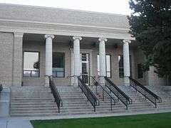
Douglas County Courthouse |
|
000000001986-08-06-0000August 6, 1986
(#86002266) |
1616 8th St.
38°57′20″N 119°45′48″W / 38.955556°N 119.763333°W / 38.955556; -119.763333 (Douglas County Courthouse) |
Minden |
|
| 4 |
Douglas County High School |
|
000000001992-03-09-0000March 9, 1992
(#92000117) |
1477 U.S. Route 395
38°56′37″N 119°45′02″W / 38.943611°N 119.750556°W / 38.943611; -119.750556 (Douglas County High School) |
Gardnerville |
|
| 5 |
Farmers Bank of Carson Valley |
|
000000001986-08-06-0000August 6, 1986
(#86002264) |
1597 Esmeralda Ave.
38°57′13″N 119°45′45″W / 38.953611°N 119.7625°W / 38.953611; -119.7625 (Farmers Bank of Carson Valley) |
Minden |
|
| 6 |
Farmer's Bank of Carson Valley |
|
000000002000-04-06-0000April 6, 2000
(#00000338) |
1596 Esmeralda Ave.
38°57′10″N 119°45′47″W / 38.952778°N 119.763056°W / 38.952778; -119.763056 (Farmer's Bank of Carson Valley) |
Minden |
|
| 7 |
Friday's Station |
|
000000001986-10-09-0000October 9, 1986
(#86003259) |
U.S. Route 50 between Kingsbury Grade and Loop Rd.
38°57′50″N 119°56′05″W / 38.963889°N 119.934722°W / 38.963889; -119.934722 (Friday's Station) |
Stateline |
|
| 8 |
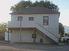
Lena N. Gale Cabin |
Upload image |
000000002001-06-12-0000June 12, 2001
(#01000586) |
726 Cedar St.
39°00′12″N 119°56′56″W / 39.003333°N 119.948889°W / 39.003333; -119.948889 (Lena N. Gale Cabin) |
Zephyr Cove |
|
| 9 |
Gardnerville Branch Jail |
|
000000002003-05-16-0000May 16, 2003
(#03000415) |
1440 Courthouse St.
38°56′29″N 119°44′30″W / 38.941389°N 119.741667°W / 38.941389; -119.741667 (Gardnerville Branch Jail) |
Gardnerville |
|
| 10 |
Gardnerville Elementary School |
|
000000002008-02-19-0000February 19, 2008
(#08000033) |
1290 Toler Ave.
38°56′23″N 119°44′38″W / 38.9398°N 119.7440°W / 38.9398; -119.7440 (Gardnerville Elementary School) |
Gardnerville |
(School Buildings in Nevada MPS)
|
| 11 |
Genoa Historic District |
|
000000001975-04-16-0000April 16, 1975
(#75001108) |
7 miles northwest of Minden on State Route 57
39°00′18″N 119°50′35″W / 39.005°N 119.843056°W / 39.005; -119.843056 (Genoa Historic District) |
Genoa |
|
| 12 |
Home Ranch |
Upload image |
000000001980-12-05-0000December 5, 1980
(#80002466) |
West of Minden
38°56′54″N 119°47′20″W / 38.948333°N 119.788889°W / 38.948333; -119.788889 (Home Ranch) |
Minden |
|
| 13 |
It-goom-mum teh-weh-weh ush-shah-ish |
Upload image |
000000002016-02-01-0000February 1, 2016
(#15001029) |
Address restricted[4]
|
Dresslerville |
|
| 14 |
Arendt Jensen House |
Upload image |
000000001989-03-08-0000March 8, 1989
(#89000126) |
1431 Ezell St.
38°56′31″N 119°44′29″W / 38.941944°N 119.741389°W / 38.941944; -119.741389 (Arendt Jensen House) |
Gardnerville |
|
| 15 |
Arendt Jensen, Jr. House |
Upload image |
000000001994-12-01-0000December 1, 1994
(#94001405) |
1243 A and 1243 B Eddie St.
38°56′32″N 119°44′46″W / 38.942222°N 119.746111°W / 38.942222; -119.746111 (Arendt Jensen, Jr. House) |
Gardnerville |
|
| 16 |
Jobs Peak Ranch |
Upload image |
000000002001-01-11-0000January 11, 2001
(#00001639) |
144 Summit Ridge Way
38°53′49″N 119°50′56″W / 38.896944°N 119.848889°W / 38.896944; -119.848889 (Jobs Peak Ranch) |
Genoa |
|
| 17 |
Lake Shore House |
Upload image |
000000001979-10-04-0000October 4, 1979
(#79001463) |
Glenbrook Rd
39°05′18″N 119°56′18″W / 39.088333°N 119.938333°W / 39.088333; -119.938333 (Lake Shore House) |
Glenbrook |
|
| 18 |
Minden Butter Manufacturing Company |
Upload image |
000000001986-08-06-0000August 6, 1986
(#86002263) |
1617 Water St.
38°57′20″N 119°45′48″W / 38.955556°N 119.763333°W / 38.955556; -119.763333 (Minden Butter Manufacturing Company) |
Minden |
|
| 19 |
Minden Elementary School |
|
000000002008-02-19-0000February 19, 2008
(#08000034) |
1638 Mono Ave.
38°57′14″N 119°46′01″W / 38.953889°N 119.766944°W / 38.953889; -119.766944 (Minden Elementary School) |
Minden |
(School Buildings in Nevada MPS)
|
| 20 |
Minden Flour Milling Company |
|
000000001978-11-14-0000November 14, 1978
(#78001721) |
6th St. and U.S. Route 395
38°57′18″N 119°45′46″W / 38.955°N 119.762778°W / 38.955; -119.762778 (Minden Flour Milling Company) |
Minden |
|
| 21 |
Minden Inn |
|
000000001986-08-06-0000August 6, 1986
(#86002262) |
1594 Esmeralda Ave.
38°57′11″N 119°45′44″W / 38.953056°N 119.762222°W / 38.953056; -119.762222 (Minden Inn) |
Minden |
|
| 22 |
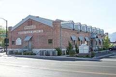
Minden Wool Warehouse |
|
000000001986-08-06-0000August 6, 1986
(#86002261) |
1615 Railroad Ave.
38°57′19″N 119°45′51″W / 38.955278°N 119.764167°W / 38.955278; -119.764167 (Minden Wool Warehouse) |
Minden |
|
| 23 |
Reese-Johnson-Virgin House |
|
000000002004-07-21-0000July 21, 2004
(#04000728) |
193 Genoa Ln.
39°00′12″N 119°50′40″W / 39.003333°N 119.844444°W / 39.003333; -119.844444 (Reese-Johnson-Virgin House) |
Genoa |
|
| 24 |
TAHOE (Shipwreck) |
|
000000002004-02-11-0000February 11, 2004
(#04000026) |
Lake Tahoe
39°05′29″N 119°57′08″W / 39.091389°N 119.952222°W / 39.091389; -119.952222 (TAHOE (Shipwreck)) |
Glenbrook |
|