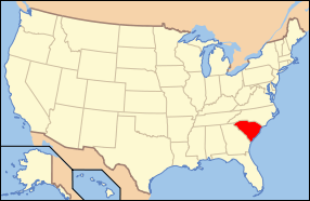
National Register of Historic Places listings in Dillon County, South Carolina
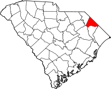
Location of Dillon County in South Carolina
This is a list of the National Register of Historic Places listings in Dillon County, South Carolina.
This is intended to be a complete list of the properties and districts on the National Register of Historic Places in Dillon County, South Carolina, United States. The locations of National Register properties and districts for which the latitude and longitude coordinates are included below, may be seen in a map.[1]
There are 18 properties and districts listed on the National Register in the county.
- This National Park Service list is complete through NPS recent listings posted December 2, 2016.[2]
Current listings
| [3] |
Name on the Register[4] |
Image |
Date listed[5] |
Location |
City or town |
Description |
|---|
| 1 |
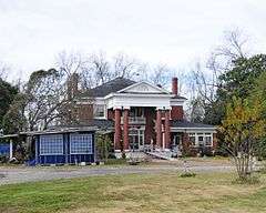
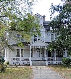
Joel Allen House |
Upload image |
000000001974-08-13-0000August 13, 1974
(#74001848) |
Northwest of Latta
34°24′42″N 79°29′33″W / 34.411667°N 79.4925°W / 34.411667; -79.4925 (Joel Allen House) |
Latta |
|
| 2 |
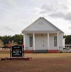
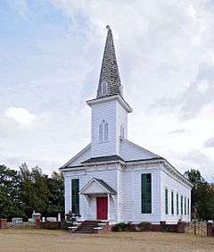
Catfish Creek Baptist Church |
|
000000001975-01-17-0000January 17, 1975
(#75001697) |
5 miles northwest of Latta at the junction of County Roads 1741 and 1763
34°21′55″N 79°29′36″W / 34.365278°N 79.493333°W / 34.365278; -79.493333 (Catfish Creek Baptist Church) |
Latta |
|
| 3 |
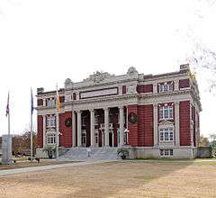
Dillon County Courthouse |
|
000000001981-10-30-0000October 30, 1981
(#81000564) |
1303 W. Main St.
34°25′05″N 79°22′32″W / 34.418056°N 79.375556°W / 34.418056; -79.375556 (Dillon County Courthouse) |
Dillon |
|
| 4 |
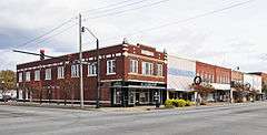
Dillon Downtown Historic District |
|
000000002003-01-24-0000January 24, 2003
(#01001549) |
Roughly bounded by E. and W. Main St, N. and S. Railroad Ave, N. MacArthur Ave, and E. Harrison St.
34°25′00″N 79°22′17″W / 34.416667°N 79.371389°W / 34.416667; -79.371389 (Dillon Downtown Historic District) |
Dillon |
|
| 5 |
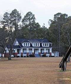
Dillon Graded School and Dillon Public School |
Upload image |
000000002014-09-30-0000September 30, 2014
(#14000818) |
405 W. Washington St.
34°25′18″N 79°22′25″W / 34.4216°N 79.3737°W / 34.4216; -79.3737 (Dillon Graded School and Dillon Public School) |
Dillon |
|
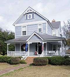
| 6 |
James W. Dillon House |
|
000000001971-05-06-0000May 6, 1971
(#71000769) |
1302 W. Main St.
34°25′07″N 79°22′28″W / 34.418611°N 79.374444°W / 34.418611; -79.374444 (James W. Dillon House) |
Dillon |
|
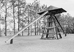
| 7 |
Early Cotton Press |
|
000000001972-11-15-0000November 15, 1972
(#72001206) |
Near the junction of South Carolina Highways 38 and 917
34°20′11″N 79°31′11″W / 34.336389°N 79.519722°W / 34.336389; -79.519722 (Early Cotton Press) |
Latta |
|
| 8 |
Hamer Hall |
|
000000001975-05-30-0000May 30, 1975
(#75001696) |
North of Hamer on U.S. Route 301
34°29′11″N 79°19′35″W / 34.486389°N 79.326389°W / 34.486389; -79.326389 (Hamer Hall) |
Hamer |
|
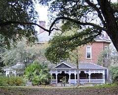
| 9 |
James W. Hamer House |
|
000000002007-09-21-0000September 21, 2007
(#07000985) |
1253 Harllees Bridge Rd.
34°28′10″N 79°24′40″W / 34.4693075°N 79.4110657°W / 34.4693075; -79.4110657 (James W. Hamer House) |
Little Rock |
|
| 10 |
John Hayes Farmstead |
|
000000002005-10-04-0000October 4, 2005
(#05001153) |
1251 South Carolina Highway 38, W.
34°20′14″N 79°31′29″W / 34.337222°N 79.524722°W / 34.337222; -79.524722 (John Hayes Farmstead) |
Latta |
|
| 11 |
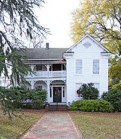
Latta Downtown Historic District |
Upload image |
000000001998-05-20-0000May 20, 1998
(#98000555) |
Roughly along E. and W. Main Sts.
34°20′15″N 79°25′57″W / 34.3375°N 79.4325°W / 34.3375; -79.4325 (Latta Downtown Historic District) |
Latta |
|
| 12 |
Latta Historic District No. 1 |
|
000000001984-05-17-0000May 17, 1984
(#84002038) |
Church, Marion, Bethea, Rice, Dew, Mauldin, and Main Sts.
34°20′25″N 79°26′03″W / 34.340278°N 79.434167°W / 34.340278; -79.434167 (Latta Historic District No. 1) |
Latta |
|
| 13 |
Latta Historic District No. 2 |
|
000000001984-05-17-0000May 17, 1984
(#84002040) |
Richardson St., Bamberg to Oak Sts.
34°20′19″N 79°25′50″W / 34.338611°N 79.430556°W / 34.338611; -79.430556 (Latta Historic District No. 2) |
Latta |
|
| 14 |
McMillan House |
|
000000001984-05-17-0000May 17, 1984
(#84002042) |
206 Maion St.
34°20′12″N 79°26′06″W / 34.336667°N 79.435°W / 34.336667; -79.435 (McMillan House) |
Latta |
|
| 15 |
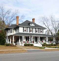
Meekins Barn |
Upload image |
000000001984-08-03-0000August 3, 1984
(#84003815) |
Off South Carolina Highway 9
34°22′25″N 79°16′02″W / 34.373611°N 79.267222°W / 34.373611; -79.267222 (Meekins Barn) |
Floydale |
|
| 16 |
St. Paul's Methodist Church |
|
000000001977-07-26-0000July 26, 1977
(#77001220) |
Off South Carolina Highway 9
34°28′38″N 79°24′08″W / 34.477222°N 79.402222°W / 34.477222; -79.402222 (St. Paul's Methodist Church) |
Little Rock |
|
| 17 |
Selkirk Farm |
|
000000001974-07-24-0000July 24, 1974
(#74001847) |
East of Bingham on Old Cashua Ferry Rd.
34°28′05″N 79°30′15″W / 34.468056°N 79.504167°W / 34.468056; -79.504167 (Selkirk Farm) |
Bingham |
|
| 18 |
Smith Barn |
|
000000001984-12-04-0000December 4, 1984
(#84000568) |
East of Floydale
34°20′32″N 79°15′10″W / 34.342222°N 79.252778°W / 34.342222; -79.252778 (Smith Barn) |
Floydale |
|
See also
References
- ↑ The latitude and longitude information provided in this table was derived originally from the National Register Information System, which has been found to be fairly accurate for about 99% of listings. For about 1% of NRIS original coordinates, experience has shown that one or both coordinates are typos or otherwise extremely far off; some corrections may have been made. A more subtle problem causes many locations to be off by up to 150 yards, depending on location in the country: most NRIS coordinates were derived from tracing out latitude and longitudes off of USGS topographical quadrant maps created under the North American Datum of 1927, which differs from the current, highly accurate WGS84 GPS system used by most on-line maps. Chicago is about right, but NRIS longitudes in Washington are higher by about 4.5 seconds, and are lower by about 2.0 seconds in Maine. Latitudes differ by about 1.0 second in Florida. Some locations in this table may have been corrected to current GPS standards.
- ↑ "National Register of Historic Places: Weekly List Actions". National Park Service, United States Department of the Interior. Retrieved on December 2, 2016.
- ↑ Numbers represent an ordering by significant words. Various colorings, defined here, differentiate National Historic Landmarks and historic districts from other NRHP buildings, structures, sites or objects.
- ↑ National Park Service (2009-03-13). "National Register Information System". National Register of Historic Places. National Park Service.
- ↑ The eight-digit number below each date is the number assigned to each location in the National Register Information System database, which can be viewed by clicking the number.
|
|---|
|
| Topics | | |
|---|
|
Lists
by county | |
|---|
|
| Lists by city | |
|---|
|
| Other lists | |
|---|
|
|
.jpg)