| [3] |
Name on the Register[4] |
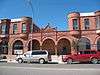
Image |
Date listed[5] |
Location |
City or town |
Description |
|---|
| 1 |
Alpine Apartments |
Upload image |
000000001998-10-30-0000October 30, 1998
(#98001299) |
200 Hickory
46°07′46″N 112°57′13″W / 46.129444°N 112.953611°W / 46.129444; -112.953611 (Alpine Apartments) |
Anaconda |
|
| 2 |
Anaconda Commercial Historic District |
|
000000001998-02-25-0000February 25, 1998
(#98000155) |
Roughly bounded by Commercial Ave., Main St., Chestnut St., and E. Park Ave.
46°07′46″N 112°56′57″W / 46.129444°N 112.949167°W / 46.129444; -112.949167 (Anaconda Commercial Historic District) |
Anaconda |
|
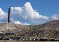
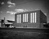
| 3 |
Anaconda Copper Mining Company Smoke Stack |
|
000000001987-04-09-0000April 9, 1987
(#87000607) |
Anaconda Copper Smelter
46°06′37″N 112°54′47″W / 46.110278°N 112.913056°W / 46.110278; -112.913056 (Anaconda Copper Mining Company Smoke Stack) |
Anaconda |
|
| 4 |
Anaconda Saddle Club |
Upload image |
000000002007-01-24-0000January 24, 2007
(#06001296) |
2704 Montana Highway 1, W.
46°09′22″N 113°02′07″W / 46.1562°N 113.0353°W / 46.1562; -113.0353 (Anaconda Saddle Club) |
Anaconda |
|
| 5 |
Ancient Order of Hibernians Hall |
|
000000001979-08-10-0000August 10, 1979
(#79003721) |
321-323 E. Commercial
46°07′46″N 112°56′54″W / 46.129444°N 112.948333°W / 46.129444; -112.948333 (Ancient Order of Hibernians Hall) |
Anaconda |
|
| 6 |
Barich Block |
|
000000001983-01-19-0000January 19, 1983
(#83001058) |
416-420 E. Park Ave.
46°07′47″N 112°57′05″W / 46.129722°N 112.951389°W / 46.129722; -112.951389 (Barich Block) |
Anaconda |
|
| 7 |
Branscombe Automobile Machine Shop |
Upload image |
000000002000-12-18-0000December 18, 2000
(#00001522) |
125 W. Commercial
46°07′56″N 112°57′14″W / 46.132222°N 112.953889°W / 46.132222; -112.953889 (Branscombe Automobile Machine Shop) |
Anaconda |
|
| 8 |
Butte, Anaconda and Pacific Railway Historic District |
Upload image |
000000001988-10-13-0000October 13, 1988
(#88001111) |
Right-of-way begins in Butte and travels to Anaconda, generally along the course of Silver Bow Creek
46°02′37″N 112°44′25″W / 46.043611°N 112.740278°W / 46.043611; -112.740278 (Butte, Anaconda and Pacific Railway Historic District) |
Anaconda |
Extends into Silver Bow County
|
| 9 |
Butte-Anaconda Historic District |
|
000000001966-10-15-0000October 15, 1966
(#66000438) |
Most of the developed areas of Anaconda, Butte, and Walkerville
46°07′45″N 112°57′10″W / 46.129167°N 112.952778°W / 46.129167; -112.952778 (Butte-Anaconda Historic District) |
Anaconda |
Extends into Silver Bow County
|
| 10 |
California Creek Quarry |
Upload image |
000000001989-01-20-0000January 20, 1989
(#88003140) |
Address Restricted
|
Anaconda |
|
| 11 |
City Hall |
Upload image |
000000001979-08-10-0000August 10, 1979
(#79003722) |
401 E. Commercial
46°07′46″N 112°56′51″W / 46.129444°N 112.9475°W / 46.129444; -112.9475 (City Hall) |
Anaconda |
|
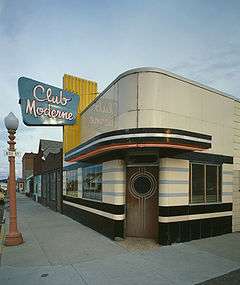
| 12 |
Club Moderne |
|
000000001986-08-14-0000August 14, 1986
(#86001498) |
811 E. Park
46°07′40″N 112°56′38″W / 46.127778°N 112.943889°W / 46.127778; -112.943889 (Club Moderne) |
Anaconda |
|
| 13 |
James V. Collins House |
Upload image |
000000002000-12-18-0000December 18, 2000
(#00001521) |
422 W. 3rd St.
46°07′52″N 112°57′31″W / 46.131111°N 112.958611°W / 46.131111; -112.958611 (James V. Collins House) |
Anaconda |
|
| 14 |
Davidson Building |
Upload image |
000000001983-01-19-0000January 19, 1983
(#83001059) |
301-303 E. Park St.
46°07′47″N 112°57′14″W / 46.129722°N 112.953889°W / 46.129722; -112.953889 (Davidson Building) |
Anaconda |
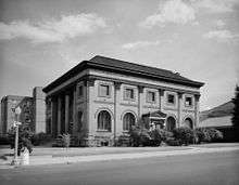
|
| 15 |
Deer Lodge County Courthouse |
|
000000001978-12-29-0000December 29, 1978
(#78001681) |
U.S. Route 10
46°07′21″N 112°57′18″W / 46.1225°N 112.955°W / 46.1225; -112.955 (Deer Lodge County Courthouse) |
Anaconda |
|
| 16 |
Theodore Eck House |
Upload image |
000000001998-10-30-0000October 30, 1998
(#98001298) |
1217 W. 4th St.
46°07′48″N 112°58′10″W / 46.13°N 112.969444°W / 46.13; -112.969444 (Theodore Eck House) |
Anaconda |
|
| 17 |
John Furst House |
Upload image |
000000001998-10-30-0000October 30, 1998
(#98001296) |
1403 W. 3rd St.
46°07′53″N 112°58′16″W / 46.131389°N 112.971111°W / 46.131389; -112.971111 (John Furst House) |
Anaconda |
|
| 18 |
Glover Cabin |
Upload image |
000000002000-12-18-0000December 18, 2000
(#00001524) |
Washoe Park
46°08′10″N 112°57′56″W / 46.136111°N 112.965556°W / 46.136111; -112.965556 (Glover Cabin) |
Anaconda |
|
| 19 |
Goosetown Historic District |
Upload image |
000000001998-02-25-0000February 25, 1998
(#98000156) |
Roughly bounded by Cedar St., Monroe St., the Birch Hill Allotment, and E. Commercial Ave.
46°07′28″N 112°56′35″W / 46.124444°N 112.943056°W / 46.124444; -112.943056 (Goosetown Historic District) |
Anaconda |
|
| 20 |
Granite Apartments |
Upload image |
000000002000-12-18-0000December 18, 2000
(#00001517) |
214 E. 3rd St.
46°07′48″N 112°57′04″W / 46.13°N 112.951111°W / 46.13; -112.951111 (Granite Apartments) |
Anaconda |
|
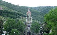
| 21 |
Hearst Free Library |
|
000000001973-06-04-0000June 4, 1973
(#73001051) |
Main and 4th Sts.
46°07′37″N 112°57′09″W / 46.126944°N 112.9525°W / 46.126944; -112.9525 (Hearst Free Library) |
Anaconda |
|
| 22 |
Lorraine Apartments |
Upload image |
000000002000-12-18-0000December 18, 2000
(#00001520) |
218 E. 3rd
46°07′47″N 112°57′02″W / 46.129722°N 112.950556°W / 46.129722; -112.950556 (Lorraine Apartments) |
Anaconda |
|
| 23 |
Duncan Matheson House |
Upload image |
000000001998-10-30-0000October 30, 1998
(#98001295) |
1300 W. 3rd St.
46°07′53″N 112°58′10″W / 46.131389°N 112.969444°W / 46.131389; -112.969444 (Duncan Matheson House) |
Anaconda |
|
| 24 |
Methodist Episcopal Church of Anaconda |
Upload image |
000000001994-07-29-0000July 29, 1994
(#94000783) |
Junction of Oak and E. 3rd Sts.
46°07′42″N 112°57′02″W / 46.128333°N 112.950556°W / 46.128333; -112.950556 (Methodist Episcopal Church of Anaconda) |
Anaconda |
|
| 25 |
Morel Bridge |
Upload image |
000000002000-12-12-0000December 12, 2000
(#00001491) |
25200 East Side Rd.
46°09′28″N 112°46′16″W / 46.157778°N 112.771111°W / 46.157778; -112.771111 (Morel Bridge) |
Anaconda |
|
| 26 |
The New Brunswick House |
Upload image |
000000002000-12-18-0000December 18, 2000
(#00001514) |
325 E. Front
46°07′56″N 112°56′54″W / 46.132222°N 112.948333°W / 46.132222; -112.948333 (The New Brunswick House) |
Anaconda |
|
| 27 |
Sheehan Boardinghouse |
Upload image |
000000002000-12-18-0000December 18, 2000
(#00001519) |
412 E. 3rd St.
46°07′42″N 112°56′54″W / 46.128333°N 112.948333°W / 46.128333; -112.948333 (Sheehan Boardinghouse) |
Anaconda |
|
| 28 |
St. Mark's Episcopal Church |
Upload image |
000000001978-12-29-0000December 29, 1978
(#78001682) |
601 Main St.
46°07′29″N 112°57′14″W / 46.124722°N 112.953889°W / 46.124722; -112.953889 (St. Mark's Episcopal Church) |
Anaconda |
|
| 29 |
US Post Office-Anaconda Main |
Upload image |
000000001986-03-14-0000March 14, 1986
(#86000677) |
218 Main St.
46°07′44″N 112°57′09″W / 46.128889°N 112.9525°W / 46.128889; -112.9525 (US Post Office-Anaconda Main) |
Anaconda |
|
| 30 |
George Waddell House |
Upload image |
000000001998-10-30-0000October 30, 1998
(#98001300) |
506 W. 3rd St.
46°07′46″N 112°57′30″W / 46.129444°N 112.958333°W / 46.129444; -112.958333 (George Waddell House) |
Anaconda |
|
| 31 |
Washoe Theater |
|
000000001982-04-30-0000April 30, 1982
(#82003162) |
305 Main St.
46°07′39″N 112°57′08″W / 46.1275°N 112.952222°W / 46.1275; -112.952222 (Washoe Theater) |
Anaconda |
|
| 32 |
West Side Historic District |
Upload image |
000000001998-04-28-0000April 28, 1998
(#98000396) |
Roughly bounded by Main St., W. 8th St., W. Park Ave., and Maple St.
46°07′33″N 112°57′17″W / 46.125833°N 112.954722°W / 46.125833; -112.954722 (West Side Historic District) |
Anaconda |
|
| 33 |
Zion Swedish Evangelical Lutheran Church |
Upload image |
000000001998-10-30-0000October 30, 1998
(#98001297) |
524 Cedar St.
46°07′29″N 112°56′57″W / 46.124722°N 112.949167°W / 46.124722; -112.949167 (Zion Swedish Evangelical Lutheran Church) |
Anaconda |
|