| [3] |
Name on the Register[4] |
Image |
Date listed[5] |
Location |
City or town |
Description |
|---|
| 1 |
Allen House |
Upload image |
000000001988-07-28-0000July 28, 1988
(#88001154) |
Smyrna Rd. and Louisiana Highway 5
32°09′33″N 93°53′25″W / 32.159167°N 93.890278°W / 32.159167; -93.890278 (Allen House) |
Keachi |
|
| 2 |
Bank of Grand Cane |
Upload image |
000000001988-02-11-0000February 11, 1988
(#88000105) |
U.S. Route 171
32°05′07″N 93°48′38″W / 32.085278°N 93.810556°W / 32.085278; -93.810556 (Bank of Grand Cane) |
Grand Cane |
|
| 3 |
Buena Vista |
Upload image |
000000001989-01-19-0000January 19, 1989
(#88003197) |
Red Bluff Rd.
32°13′59″N 93°47′32″W / 32.233056°N 93.792222°W / 32.233056; -93.792222 (Buena Vista) |
Stonewall |
|
| 4 |
Community Rosenwald School |
Upload image |
000000002009-07-22-0000July 22, 2009
(#09000545) |
Louisiana Highway 3015
32°06′25″N 93°42′47″W / 32.1070°N 93.7130°W / 32.1070; -93.7130 (Community Rosenwald School) |
Grand Cane |
|
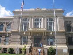
| 5 |
DeSoto Parish Courthouse |
|
000000001987-01-22-0000January 22, 1987
(#86003677) |
Junction of Adams and Texas Sts.
32°02′23″N 93°42′35″W / 32.039722°N 93.709722°W / 32.039722; -93.709722 (DeSoto Parish Courthouse) |
Mansfield |
|
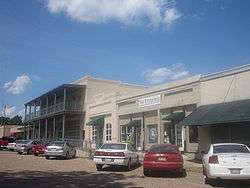
| 6 |
Grand Cane Historic District |
Upload image |
000000001995-07-07-0000July 7, 1995
(#95000815) |
U.S. Route 171, roughly between Burrow and Graham Sts.
32°05′01″N 93°48′35″W / 32.083611°N 93.809722°W / 32.083611; -93.809722 (Grand Cane Historic District) |
Grand Cane |
|
| 7 |
Grand Cane United Methodist Church |
Upload image |
000000001992-01-28-0000January 28, 1992
(#91002024) |
U.S. Route 171 south of Louisiana Highway 3015
32°04′51″N 93°48′32″W / 32.080833°N 93.808889°W / 32.080833; -93.808889 (Grand Cane United Methodist Church) |
Grand Cane |
|
| 8 |
Guy House |
Upload image |
000000001988-02-11-0000February 11, 1988
(#88000103) |
Off Louisiana Highway 513, 5 miles south of Mansfield
31°58′18″N 93°40′21″W / 31.971667°N 93.6725°W / 31.971667; -93.6725 (Guy House) |
Mansfield |
|
| 9 |
International Boundary Marker |
Upload image |
000000001977-04-13-0000April 13, 1977
(#77001463) |
Southeast of Deadwood off Texas State Highway 31 on the Louisiana/Texas state line
32°02′01″N 94°02′32″W / 32.033611°N 94.042222°W / 32.033611; -94.042222 (International Boundary Marker) |
Logansport |
Extends into Panola County, Texas
|
| 10 |
Kansas City Southern Depot |
Upload image |
000000001989-01-19-0000January 19, 1989
(#88003198) |
Polk St. on Kansas City Southern railroad tracks
32°02′08″N 93°41′30″W / 32.035556°N 93.691667°W / 32.035556; -93.691667 (Kansas City Southern Depot) |
Mansfield |
|
| 11 |
Keachi Baptist Church |
Upload image |
000000001988-10-20-0000October 20, 1988
(#88002039) |
Louisiana Highway 172
32°11′18″N 93°54′34″W / 32.188333°N 93.909444°W / 32.188333; -93.909444 (Keachi Baptist Church) |
Keachi |
|
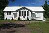
| 12 |
Keachi Presbyterian Church |
|
000000001988-06-30-0000June 30, 1988
(#88000981) |
Louisiana Highway 5
32°11′17″N 93°54′10″W / 32.188056°N 93.902778°W / 32.188056; -93.902778 (Keachi Presbyterian Church) |
Keachi |
|
| 13 |
Keachi Store |
Upload image |
000000001988-10-20-0000October 20, 1988
(#88002036) |
Junction of Louisiana Highway 5 and 789
32°11′19″N 93°54′20″W / 32.188611°N 93.905556°W / 32.188611; -93.905556 (Keachi Store) |
Keachi |
|
| 14 |
Keachi United Methodist Church |
Upload image |
000000001988-07-14-0000July 14, 1988
(#88001046) |
Louisiana Highway 5
32°11′20″N 93°54′12″W / 32.188889°N 93.903333°W / 32.188889; -93.903333 (Keachi United Methodist Church) |
Keachi |
|
| 15 |
Land's End Plantation |
Upload image |
000000001972-04-26-0000April 26, 1972
(#72001453) |
7 miles southeast of Stonewall on Red Bluff Rd.
32°14′27″N 93°45′21″W / 32.240833°N 93.755833°W / 32.240833; -93.755833 (Land's End Plantation) |
Stonewall |
|
| 16 |
Liberty Lodge No. 123, F&AM |
Upload image |
000000001989-01-13-0000January 13, 1989
(#88003136) |
Louisiana Highways 5 and 172
32°11′15″N 93°54′21″W / 32.1875°N 93.905833°W / 32.1875; -93.905833 (Liberty Lodge No. 123, F&AM) |
Keachi |
|
| 17 |
Longstreet Rosenwald School |
|
000000002009-07-22-0000July 22, 2009
(#09000546) |
Louisiana Highway 5
32°07′18″N 93°56′33″W / 32.1216°N 93.9426°W / 32.1216; -93.9426 (Longstreet Rosenwald School) |
Longstreet |
|
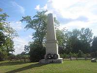
| 18 |
Mansfield Battle Park |
|
000000001973-04-13-0000April 13, 1973
(#73002131) |
4 miles southeast of Mansfield on Louisiana Highway 175
32°00′38″N 93°39′03″W / 32.010556°N 93.650833°W / 32.010556; -93.650833 (Mansfield Battle Park) |
Mansfield |
|
| 19 |
Mansfield Historic District |
|
000000001988-10-27-0000October 27, 1988
(#88002067) |
Texas and Adams Sts. at Courthouse Sq.
32°02′20″N 93°42′38″W / 32.038889°N 93.710556°W / 32.038889; -93.710556 (Mansfield Historic District) |
Mansfield |
|
| 20 |
Mundy-McFarland House |
Upload image |
000000001979-12-06-0000December 6, 1979
(#79003120) |
200 Welsh St.
32°02′13″N 93°42′10″W / 32.036944°N 93.702778°W / 32.036944; -93.702778 (Mundy-McFarland House) |
Mansfield |
|
| 21 |
Myrtle Hill Plantation House |
Upload image |
000000001974-12-04-0000December 4, 1974
(#74002185) |
Southeast of Gloster off Louisiana Highway 5
32°09′49″N 93°46′40″W / 32.163611°N 93.777778°W / 32.163611; -93.777778 (Myrtle Hill Plantation House) |
Gloster |
|
| 22 |
The Oaks |
Upload image |
000000001989-01-19-0000January 19, 1989
(#88003203) |
Louisiana Highway 172
32°10′58″N 93°56′18″W / 32.182778°N 93.938333°W / 32.182778; -93.938333 (The Oaks) |
Keachi |
|
| 23 |
Prude House |
Upload image |
000000001988-07-14-0000July 14, 1988
(#88001048) |
Louisiana Highway 5
32°08′55″N 93°55′25″W / 32.148611°N 93.923611°W / 32.148611; -93.923611 (Prude House) |
Keachi |
|
| 24 |
Roseneath |
Upload image |
000000001989-01-13-0000January 13, 1989
(#88003137) |
Louisiana Highway 5
32°10′25″N 93°45′55″W / 32.173611°N 93.765278°W / 32.173611; -93.765278 (Roseneath) |
Gloster |
|
| 25 |
Thomas Scott House |
Upload image |
000000001986-11-06-0000November 6, 1986
(#86003131) |
Louisiana Highway 5, 4 miles east of Gloster
32°10′51″N 93°45′30″W / 32.180833°N 93.758333°W / 32.180833; -93.758333 (Thomas Scott House) |
Gloster |
|
| 26 |
Spell House |
Upload image |
000000001988-07-14-0000July 14, 1988
(#88001047) |
Louisiana Highway 5
32°10′41″N 93°54′52″W / 32.178056°N 93.914444°W / 32.178056; -93.914444 (Spell House) |
Keachi |
|
| 27 |
Stribling House |
Upload image |
000000001989-05-11-0000May 11, 1989
(#89000403) |
U.S. Route 84
31°58′32″N 93°50′48″W / 31.975556°N 93.846667°W / 31.975556; -93.846667 (Stribling House) |
Mansfield |
|
| 28 |
Swearingen House |
Upload image |
000000001988-11-17-0000November 17, 1988
(#88002658) |
Louisiana Highway 5
32°11′21″N 93°53′33″W / 32.189167°N 93.8925°W / 32.189167; -93.8925 (Swearingen House) |
Keachi |
|
| 29 |
U.S. Post Office |
Upload image |
000000001983-01-12-0000January 12, 1983
(#83000497) |
104 Jefferson St.
32°02′04″N 93°42′31″W / 32.034444°N 93.708611°W / 32.034444; -93.708611 (U.S. Post Office) |
Mansfield |
|
| 30 |
Williams House |
Upload image |
000000001994-07-22-0000July 22, 1994
(#94000682) |
407 Texas St.
32°02′16″N 93°41′56″W / 32.037778°N 93.698889°W / 32.037778; -93.698889 (Williams House) |
Mansfield |
|
| 31 |
Wood Park |
Upload image |
000000001983-01-21-0000January 21, 1983
(#83000498) |
South of Mansfield off Louisiana Highway 175
31°58′44″N 93°26′42″W / 31.978889°N 93.445°W / 31.978889; -93.445 (Wood Park) |
Mansfield |
|

_Presbyterian_Church_IMG_0933.JPG)