National Register of Historic Places listings in Dallas County, Texas
List of Registered Historic Places in Dallas County, Texas
This is intended to be a complete list of properties and districts listed on the National Register of Historic Places in Dallas County, Texas. The locations of National Register properties and districts (at least for all showing latitude and longitude coordinates below) may be seen in a Google map by clicking on "Map of all coordinates".[1]
- This National Park Service list is complete through NPS recent listings posted December 2, 2016.[2]
| [3] | Name on the Register[4] | Image | Date listed[5] | Location | City or town | Description |
|---|---|---|---|---|---|---|
| 1 | 511 Akard Building | 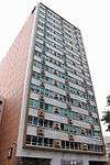 |
(#14000103) |
511 N. Akard 32°47′03″N 96°48′02″W / 32.784149°N 96.800587°W |
Dallas | |
| 2 | 1926 Republic National Bank | 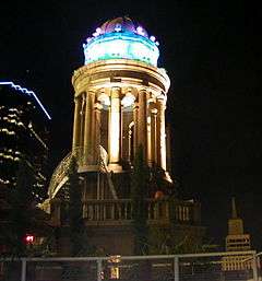 |
(#05001543) |
1309 Main St. 32°46′56″N 96°48′03″W / 32.782222°N 96.800833°W |
Dallas | |
| 3 | 4928 Bryan Street Apartments | 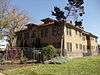 |
(#08000539) |
4928 Bryan Street 32°48′16″N 96°46′20″W / 32.804444°N 96.772222°W |
Dallas | |
| 4 | W.H. Adamson High School | 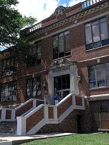 |
(#11000343) |
201 E. 9th St. 32°44′52″N 96°49′19″W / 32.747778°N 96.821944°W |
Dallas | |
| 5 | Alcalde Street-Crockett School Historic District |  |
(#95000330) |
200-500 Alcalde, 421-421A N. Carroll and 4315 Victor 32°47′33″N 96°46′12″W / 32.7925°N 96.77°W |
Dallas | |
| 6 | D. M. Angle House |  |
(#85000710) |
800 Beltline 32°35′22″N 96°57′30″W / 32.589444°N 96.958333°W |
Cedar Hill | |
| 7 | Alfred Horatio Belo House |  |
(#75001965) |
2115 Ross Ave. 32°47′17″N 96°47′55″W / 32.788188°N 96.798517°W |
Dallas | |
| 8 | Didaco and Ida Bianchi House |  |
(#95000311) |
4503 Reiger Ave. 32°47′35″N 96°46′07″W / 32.793056°N 96.768611°W |
Dallas | |
| 9 | Bluitt Sanitarium |  |
(#06000651) |
2036 Commerce St. 32°46′58″N 96°47′33″W / 32.782778°N 96.7925°W |
Dallas | |
| 10 | Alfred and Juantia Bromberg House |  |
(#08000658) |
3201 Wendover Road 32°49′29″N 96°44′35″W / 32.82477°N 96.743022°W |
Dallas | |
| 11 | Building at 3525 Turtle Creek Boulevard | .jpg) |
(#08000475) |
3525 Turtle Creek Boulevard 32°48′40″N 96°48′11″W / 32.811111°N 96.803056°W |
Dallas | |
| 12 | Bryan-Peak Commercial Historic District |  |
(#95000327) |
4214-4311 Bryan Ave. and 1325-1408 N. Peak 32°47′51″N 96°46′45″W / 32.7975°N 96.779167°W |
Dallas | |
| 13 | William Bryant Jr. House |  |
(#85000711) |
S. Broad and Cooper 32°35′09″N 96°57′25″W / 32.585833°N 96.956944°W |
Cedar Hill | |
| 14 | Busch-Kirby Building |  |
(#80004489) |
1501-1509 Main St. 32°46′49″N 96°47′56″W / 32.780278°N 96.798889°W |
Dallas | Originally only the Busch Building, but expanded and renamed via boundary increase of September 12, 1996 |
| 15 | Cedar Springs Place |  |
(#91001901) |
2531 Lucas Dr. 32°48′50″N 96°49′14″W / 32.813889°N 96.820556°W |
Dallas | |
| 16 | Central Congregational Church |  |
(#95000307) |
1530 N. Carroll 32°48′07″N 96°46′43″W / 32.801944°N 96.778611°W |
Dallas | |
| 17 | Chevrolet Motor Company Building |  |
(#03000277) |
3221 Commerce 32°47′04″N 96°46′36″W / 32.784444°N 96.776667°W |
Dallas | |
| 18 | Claremont Apartments |  |
(#95000313) |
4636 Ross Ave. 32°48′17″N 96°46′37″W / 32.804722°N 96.776944°W |
Dallas | |
| 19 | Clements Hall |  |
(#80004087) |
3200 Dyer St. 32°50′36″N 96°47′03″W / 32.843333°N 96.784167°W |
Dallas | |
| 20 | Colonial Hill Historic District |  |
(#95000334) |
Bounded by Pennsylvania Ave., I-45, US 75 and Hatcher 32°45′04″N 96°45′58″W / 32.751111°N 96.766111°W |
Dallas | |
| 21 | Continental Gin Company |  |
(#83003134) |
3301-3333 Elm St., 212 and 232 Trunk Ave. 32°47′10″N 96°46′37″W / 32.786111°N 96.776944°W |
Dallas | |
| 22 | Dallas Coffin Company |  |
(#12000350) |
1325 S. Lamar 32°46′04″N 96°47′46″W / 32.76769°N 96.79604°W |
Dallas | |
| 23 | Dallas County Courthouse | 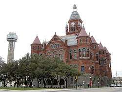 |
(#76002019) |
Houston and Commerce Sts. 32°46′45″N 96°48′25″W / 32.779167°N 96.806944°W |
Dallas | Also known as "Old Red Courthouse". Now Old Red Museum. |
| 24 | Dallas Downtown Historic District |  |
(#04000894) |
Roughly bounded by Federal, N. St. Paul, Pacific, Harwood, S. Pearl, Commerce, S, Ervay, Akard, Commerce, and Field; also bounded by Jackson, North Hardwood Commerce, the north-south line between S. Pearl Expressway, and S. Hardwood Canton 32°46′57″N 96°47′51″W / 32.782608°N 96.7975°W |
Dallas | Second set of boundaries represents a boundary increase of January 9, 2009 |
| 25 | Dallas Fire Station No. 16 |  |
(#97000363) |
5501 Columbia Ave. 32°47′56″N 96°45′18″W / 32.798889°N 96.755°W |
Dallas | |
| 26 | Dallas Hall | .JPG) |
(#78002913) |
Southern Methodist University campus 32°50′42″N 96°47′05″W / 32.845°N 96.784722°W |
Dallas | |
| 27 | Dallas High School Historic District |  |
(#96000035) |
2218 Bryan St. 32°47′10″N 96°47′36″W / 32.786111°N 96.793333°W |
Dallas | |
| 28 | Dallas National Bank |  |
(#05000419) |
1530 Main and 1511 Commerce St. 32°46′56″N 96°47′54″W / 32.782222°N 96.798333°W |
Dallas | |
| 29 | Dallas Scottish Rite Temple | 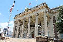 |
(#80004088) |
Harwood and Young Sts. 32°46′43″N 96°47′31″W / 32.778611°N 96.791944°W |
Dallas | |
| 30 | Dallas Tent and Awning Building |  |
(#99001292) |
3401 Commerce St. 32°47′06″N 96°46′28″W / 32.785°N 96.774444°W |
Dallas | |
| 31 | Dallas Times Herald Pasadena Perfect Home |  |
(#06000819) |
6938 Wildgrove Ave. 32°49′08″N 96°44′15″W / 32.818889°N 96.7375°W |
Dallas | |
| 32 | Dallas Union Terminal |  |
(#75001966) |
400 S. Houston St. 32°46′32″N 96°48′27″W / 32.775556°N 96.8075°W |
Dallas | |
| 33 | Dealey Plaza Historic District |  |
(#93001607) |
Roughly bounded by Pacific Ave., Market St., Jackson St. and right of way of Dallas Right of Way Management Company 32°46′42″N 96°48′26″W / 32.778333°N 96.807222°W |
Dallas | |
| 34 | DeGolyer Estate |  |
(#78002914) |
8525 Garland Rd. 32°49′17″N 96°43′03″W / 32.821389°N 96.7175°W |
Dallas | |
| 35 | Dixon-Moore House | Upload image | (#95000320) |
2716 Peabody 32°48′07″N 96°46′43″W / 32.801944°N 96.778611°W |
Dallas | Demolished. |
| 36 | James H. and Molly Ellis House |  |
(#95000323) |
2426 Pine 32°45′17″N 96°45′42″W / 32.754722°N 96.761667°W |
Dallas | |
| 37 | Emmanuel Lutheran Church |  |
(#95000315) |
4301 San Jacinto 32°48′02″N 96°46′51″W / 32.800556°N 96.780833°W |
Dallas | |
| 38 | James W. Fannin Elementary School |  |
(#95000314) |
4800 Ross Ave. 32°48′19″N 96°46′32″W / 32.805278°N 96.775556°W |
Dallas | |
| 39 | Fidelity Union Life Insurance Building | _cityscape.jpg) |
(#09000306) |
1511 Bryan and 1507 Pacific Ave. 32°46′57″N 96°47′59″W / 32.7825°N 96.799722°W |
Dallas | |
| 40 | Fred Florence Hall |  |
(#80004089) |
3330 University Blvd. 32°50′43″N 96°47′10″W / 32.845278°N 96.786111°W |
Dallas | |
| 41 | Old Forest Avenue High School |  |
(#95000318) |
3000 Martin Luther King, Jr., Blvd. 32°46′16″N 96°45′53″W / 32.771111°N 96.764722°W |
Dallas | |
| 42 | G & J Manufacturing |  |
(#02000992) |
3912 Willow St. 32°47′08″N 96°46′13″W / 32.785556°N 96.770278°W |
Dallas | |
| 43 | Samuel and Julia Gilbert House |  |
(#88002063) |
2540 Farmers Branch Ln. 32°55′05″N 96°53′26″W / 32.918056°N 96.890556°W |
Farmers Branch | |
| 44 | Goodyear Tire and Rubber Company Building and B.F. Goodrich Building |  |
(#02000009) |
2809 Parry Ave. and 4136-40 Commerce St. 32°46′29″N 96°45′56″W / 32.774722°N 96.765556°W |
Dallas | |
| 45 | Grace Methodist Episcopal Church | 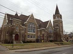 |
(#82001736) |
4105 Junius St. 32°47′36″N 96°46′32″W / 32.793333°N 96.775556°W |
Dallas | |
| 46 | Greenway Parks Historic District |  |
(#07001383) |
Bounded by W. Mockingbird Ln., W. University Blvd., Inwood & N. Dallas Tollway. 32°50′27″N 96°49′04″W / 32.840709°N 96.817814°W |
Dallas | |
| 47 | George C. Greer House |  |
(#96001563) |
5439 Swiss Ave. 32°48′23″N 96°45′53″W / 32.806389°N 96.764722°W |
Dallas | |
| 48 | Gulf Oil Distribution Facility | |
(#10000144) |
501 S. 2nd St. 32°46′56″N 96°46′22″W / 32.782222°N 96.772778°W |
Dallas | |
| 49 | Harlan Building |  |
(#04000102) |
2018 Cadiz St. 32°46′49″N 96°47′28″W / 32.780278°N 96.791111°W |
Dallas | |
| 50 | Z. T. (Tip) Hawkes House |  |
(#85000712) |
132 N. Potter St. 32°35′28″N 96°57′33″W / 32.591111°N 96.959167°W |
Cedar Hill | |
| 51 | Highland Park Shopping Village |  |
(#97001393) |
Jct. of Preston Rd. and Mockingbird Ln. 32°50′08″N 96°48′18″W / 32.835556°N 96.805°W |
Highland Park | |
| 52 | Hilton Hotel |  |
(#85003092) |
1933 Main St. 32°46′54″N 96°47′39″W / 32.781667°N 96.794167°W |
Dallas | |
| 53 | Hotel Adolphus |  |
(#83003133) |
1315 Commerce St. 32°46′47″N 96°47′57″W / 32.779722°N 96.799167°W |
Dallas | |
| 54 | Houston Street Viaduct | .jpg) |
(#84001641) |
Houston St. roughly between Arlington St. and Lancaster Ave. 32°46′12″N 96°48′31″W / 32.77°N 96.808611°W |
Dallas | |
| 55 | Hyer Hall | 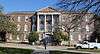 |
(#80004090) |
6424 Hill Lane 32°50′41″N 96°47′02″W / 32.844722°N 96.783889°W |
Dallas | |
| 56 | Interstate Forwarding Company Warehouse |  |
(#92000021) |
3200 Main St. 32°47′05″N 96°46′37″W / 32.784722°N 96.776944°W |
Dallas | |
| 57 | Joffre-Gilbert House |  |
(#14000473) |
309 South O'Connor Road 32°48′41″N 96°57′01″W / 32.811412°N 96.950369°W |
Irving | |
| 58 | Johnson Rooming House |  |
(#14000962) |
1026 N. Beckley Avenue 32°45′32″N 96°49′21″W / 32.758804°N 96.822584°W |
Dallas | |
| 59 | Kessler Park Historic District |  |
(#94000607) |
Roughly bounded by Kidd Springs, Stewart, Oak Cliff, Plymouth, I-30, Turner, Colorado, and Sylvan; also bounded by Turner, Colorado, Sylvan and Salmon 32°45′25″N 96°50′39″W / 32.756944°N 96.844167°W |
Dallas | Second set of boundaries represents a boundary increase of September 7, 1995 |
| 60 | King's Highway Historic District |  |
(#94000606) |
900-1500 Blocks of King's Highway between W. Davis St. and Montclair Ave. 32°45′07″N 96°50′32″W / 32.751944°N 96.842222°W |
Dallas | |
| 61 | Lake Cliff Historic District |  |
(#94000609) |
Roughly bounded by E. 6th St., Beckley Ave., Zangs Blvd. and Marsalis Ave. 32°45′23″N 96°49′06″W / 32.756389°N 96.818333°W |
Dallas | |
| 62 | Lamar-McKinney Bridge | 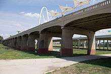 |
(#15000708) |
Across Trinity River at Continental Avenue 32°46′52″N 96°49′20″W / 32.781106°N 96.822302°W |
Dallas | |
| 63 | Lancaster Avenue Commercial Historic District |  |
(#94000605) |
Roughly bounded by E. Jefferson Blvd., S. Marsalis, E. 10th St., E. 9th St. and N. Lancaster Ave. 32°44′54″N 96°48′53″W / 32.748333°N 96.814722°W |
Dallas | |
| 64 | Stephen Decatur Lawrence Farmstead |  |
(#99001139) |
701 E. Kearney St. 32°46′13″N 96°35′20″W / 32.770278°N 96.588889°W |
Mesquite | |
| 65 | Mark and Maybelle Lemmon House | 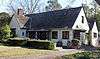 |
(#06000513) |
3211 Mockingbird Ln. 32°50′17″N 96°47′04″W / 32.838056°N 96.784444°W |
Highland Park | |
| 66 | Levi-Moses House |  |
(#95000316) |
2433 Martin Luther King, Jr., Blvd. 32°45′56″N 96°46′20″W / 32.765556°N 96.772222°W |
Dallas | |
| 67 | Levi-Topletz House | 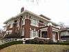 |
(#95000317) |
2603 Martin Luther King, Jr., Blvd. 32°46′02″N 96°46′13″W / 32.767222°N 96.770278°W |
Dallas | |
| 68 | Lincoln Paint and Color Company Building | 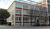 |
(#02000730) |
3210 Main 32°47′06″N 96°46′36″W / 32.785°N 96.776667°W |
Dallas | |
| 69 | Magnolia Building | 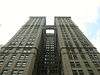 |
(#78002915) |
108 S. Akard St. 32°46′48″N 96°47′56″W / 32.78°N 96.798889°W |
Dallas | |
| 70 | Magnolia Petroleum Company City Sales and Warehouse |  |
(#94001473) |
1607 Lyte St. 32°47′33″N 96°48′37″W / 32.7925°N 96.810278°W |
Dallas | |
| 71 | Majestic Theatre |  |
(#77001437) |
1925 Elm St. 32°47′01″N 96°47′40″W / 32.783611°N 96.794444°W |
Dallas | |
| 72 | Mary Apartments |  |
(#95000310) |
4524 Live Oak 32°47′58″N 96°46′30″W / 32.799444°N 96.775°W |
Dallas | |
| 73 | Mayflower Building |  |
(#14001227) |
411 North Akard Street 32°46′59″N 96°48′03″W / 32.783029°N 96.800863°W |
Dallas | |
| 74 | McFarlin Memorial Auditorium |  |
(#80004091) |
6405 Hillcrest Rd. 32°50′38″N 96°47′10″W / 32.843889°N 96.786111°W |
Dallas | |
| 75 | Roger D. McIntosh House | Upload image | (#83003135) |
1518 Abrams Rd. 32°48′25″N 96°45′13″W / 32.806944°N 96.753611°W |
Dallas | |
| 76 | Medical Dental Building |  |
(#00001537) |
300 Blk. of West Jefferson Blvd. 32°44′36″N 96°49′37″W / 32.743333°N 96.826944°W |
Dallas | |
| 77 | Miller and Stemmons Historic District |  |
(#94000611) |
Roughly bounded by W. Davis St., Woodlawn Ave., Neches and Elsbeth 32°45′09″N 96°49′39″W / 32.7525°N 96.8275°W |
Dallas | |
| 78 | John Hickman Miller House |  |
(#80004092) |
3506 Cedar Springs 32°48′24″N 96°48′20″W / 32.806667°N 96.805556°W |
Dallas | |
| 79 | John E. Mitchell Company Plant | 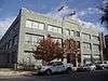 |
(#91000118) |
3800 Commerce St. 32°47′05″N 96°46′16″W / 32.784722°N 96.771111°W |
Dallas | |
| 80 | Monroe Shops | 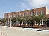 |
(#07000130) |
2111 S. Corinth St. 32°43′27″N 96°48′15″W / 32.724167°N 96.804167°W |
Dallas | |
| 81 | Mrs. Baird's Bread Company Building | 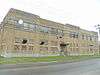 |
(#95000309) |
1401 N. Carroll 32°48′01″N 96°46′36″W / 32.800278°N 96.776667°W |
Dallas | |
| 82 | Munger Place Historic District | 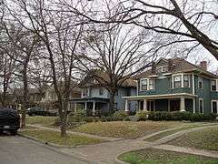 |
(#78002916) |
Roughly bounded by Henderson, Junius, Prairie, and Reiger Sts. 32°47′58″N 96°45′51″W / 32.799444°N 96.764167°W |
Dallas | |
| 83 | North Bishop Avenue Commercial Historic District | 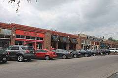 |
(#94000608) |
Roughly bounded by 9th St., Davis St., Adams and Madison 32°44′50″N 96°49′42″W / 32.747222°N 96.828333°W |
Dallas | |
| 84 | Number 4 Hook and Ladder Company | .jpg) |
(#81000627) |
Cedar Springs Rd. and Reagan St. 32°48′35″N 96°48′32″W / 32.809722°N 96.808889°W |
Dallas | |
| 85 | Oak Lawn Methodist Episcopal Church, South |  |
(#88000176) |
3014 Oak Lawn Ave. 32°48′33″N 96°48′29″W / 32.809167°N 96.808056°W |
Dallas | |
| 86 | One Main Place |  |
(#15000245) |
1201 Main Street 32°46′50″N 96°48′07″W / 32.780428°N 96.801996°W |
Dallas | |
| 87 | Paine House | 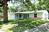 |
(#14000963) |
2515 West 5th Street 32°48′35″N 96°58′46″W / 32.809725°N 96.979311°W |
Irving | Location where Lee Harvey Oswald stayed the night before the assassination of President John F. Kennedy. |
| 88 | Parkland Hospital |  |
(#10000249) |
3819 Maple Avenue 32°48′15″N 96°48′56″W / 32.804236°N 96.815417°W |
Dallas | Original Parkland Hospital building |
| 89 | Stanley Patterson Hall | 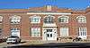 |
(#80004094) |
3128 Dyer St. 32°50′36″N 96°46′56″W / 32.843333°N 96.782222°W |
Dallas | |
| 90 | Peak's Suburban Addition Historic District | 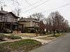 |
(#95000328) |
Roughly bounded by Sycamore, Peak, Worth and Fitzhugh 32°47′44″N 96°46′24″W / 32.795556°N 96.773333°W |
Dallas | |
| 91 | Perkins Hall of Administration |  |
(#80004095) |
6425 Hillcrest Rd. 32°50′41″N 96°47′09″W / 32.844722°N 96.785833°W |
Dallas | |
| 92 | Purvin-Hexter Building |  |
(#05001541) |
2038 Commerce St. 32°46′58″N 96°47′35″W / 32.782778°N 96.793056°W |
Dallas | |
| 93 | Queen City Heights Historic District |  |
(#95000332) |
Roughly bounded by Eugene, Cooper, Latimer, Kynard and Dildock 32°45′36″N 96°45′47″W / 32.76°N 96.763056°W |
Dallas | |
| 94 | Randlett House |  |
(#78002920) |
401 S. Centre St. 32°35′26″N 96°45′20″W / 32.590556°N 96.755556°W |
Lancaster | |
| 95 | Capt. R. A. Rawlins House |  |
(#78002921) |
2219 Dowling St. 32°34′49″N 96°45′22″W / 32.580278°N 96.756111°W |
Lancaster | |
| 96 | Republic National Bank |  |
(#05000243) |
300 N. Ervay/325 N. St. Paul St. 32°47′06″N 96°47′51″W / 32.785°N 96.7975°W |
Dallas | |
| 97 | Dr. Rufus A. Roberts House |  |
(#85000713) |
210 S. Broad St. 32°35′17″N 96°57′26″W / 32.588056°N 96.957222°W |
Cedar Hill | |
| 98 | Romine Avenue Historic District | .jpg) |
(#95000333) |
2300-2400 blocks of Romine Ave., N side 32°45′32″N 96°45′54″W / 32.758889°N 96.765°W |
Dallas | |
| 99 | Rosemont Crest Historic District |  |
(#94000610) |
Roughly bounded by 10th St., Oak Cliff Blvd., W. Davis St., N. Brighton Ave., W. 8th St. and Rosemont Ave. 32°44′48″N 96°51′02″W / 32.746667°N 96.850556°W |
Dallas | |
| 100 | Rush-Crabb House | Upload image | (#95000321) |
2718 Pennsylvania 32°45′57″N 96°46′01″W / 32.765833°N 96.766944°W |
Dallas | |
| 101 | Sanger Brothers Complex |  |
(#75001967) |
Block 32, bounded by Elm, Lamar, Main and Austin Sts. 32°46′47″N 96°48′15″W / 32.779722°N 96.804167°W |
Dallas | |
| 102 | Santa Fe Terminal Buildings No. 1 and No. 2 | 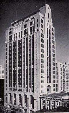 |
(#97000478) |
1114 Commerce St. and 1118 Jackson St. 32°47′48″N 96°48′03″W / 32.796667°N 96.800833°W |
Dallas | |
| 103 | Santa Fe Terminal Building No. 4 | 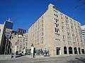 |
(#11000344) |
1033 Young St. 32°46′37″N 96°48′04″W / 32.776944°N 96.801111°W |
Dallas | |
| 104 | Everard Sharrock, Jr., Farm | Upload image | (#15000877) |
6900 Grady Niblo Rd. 32°41′02″N 96°56′23″W / 32.684°N 96.939675°W |
Dallas | |
| 105 | Thomas Shiels House |  |
(#95000312) |
4602 Reiger Ave. 32°47′37″N 96°46′02″W / 32.793611°N 96.767222°W |
Dallas | |
| 106 | Ascher Silberstein School |  |
(#95000325) |
2425 Pine St. 32°45′21″N 96°45′40″W / 32.755833°N 96.761111°W |
Dallas | |
| 107 | Snider Hall |  |
(#80004096) |
3305 Dyer St. 32°50′33″N 96°47′09″W / 32.8425°N 96.785833°W |
Dallas | |
| 108 | South Boulevard-Park Row Historic District |  |
(#79002930) |
South Blvd. and Park Row from Central 32°46′05″N 96°46′20″W / 32.768056°N 96.772222°W |
Dallas | |
| 109 | Jacob and Eliza Spake House |  |
(#85002912) |
2600 State St. 32°47′43″N 96°47′58″W / 32.795278°N 96.799444°W |
Dallas | |
| 110 | Stanard-Tilton Flour Mill | .jpg) |
(#97001187) |
2400 S. Ervay St. 32°46′00″N 96°46′55″W / 32.766667°N 96.781944°W |
Dallas | |
| 111 | Stoneleigh Court Hotel |  |
(#07000989) |
2927 Maple Ave. 32°47′51″N 96°48′25″W / 32.7975°N 96.806944°W |
Dallas | |
| 112 | Strain Farm-W.A. Strain House |  |
(#78002922) |
400 E. Pecan St.; also 400 Lancaster-Hutchins Rd. 32°35′16″N 96°44′58″W / 32.587778°N 96.749444°W |
Lancaster | Second address represents a boundary increase of September 17, 2001 |
| 113 | Straus House |  |
(#85001495) |
400 Cedar 32°35′18″N 96°57′15″W / 32.588333°N 96.954167°W |
Cedar Hill | |
| 114 | Swiss Avenue Historic District |  |
(#74002068) |
Swiss Ave. between Fitzhugh and LaVista 32°48′25″N 96°45′49″W / 32.806944°N 96.763611°W |
Dallas | |
| 115 | Tenth Street Historic District |  |
(#94000604) |
Roughly bounded by E. Clarendon Dr., S. Fleming Ave., I-35E, E. 8th St. and the E end of Church, E. 9th and Plum Sts. 32°44′52″N 96°48′23″W / 32.747778°N 96.806389°W |
Dallas | |
| 116 | Texas Centennial Exposition Buildings (1936-1937) |  |
(#86003488) |
Bounded by Texas and Pacific RR, Pennsylvania, Second, and Parry Aves. 32°46′46″N 96°45′35″W / 32.779444°N 96.759722°W |
Dallas | |
| 117 | Texas Farm and Ranch Building |  |
(#99001499) |
3300 Main St. 32°47′07″N 96°46′31″W / 32.785278°N 96.775278°W |
Dallas | |
| 118 | Texas Theatre | .jpg) |
(#03000187) |
231 W. Jefferson Blvd. 32°44′36″N 96°49′32″W / 32.743333°N 96.825556°W |
Dallas | |
| 119 | Titche-Goettinger Building |  |
(#96000586) |
1901 Main St. 32°47′26″N 96°47′42″W / 32.790556°N 96.795°W |
Dallas | |
| 120 | Trinity English Lutheran Church |  |
(#95000319) |
3100 Martin Luther King, Jr., Blvd. 32°46′19″N 96°45′52″W / 32.771944°N 96.764444°W |
Dallas | |
| 121 | Turtle Creek Pump Station |  |
(#01000103) |
3630 Harry Hines Blvd. 32°46′06″N 96°48′09″W / 32.768333°N 96.8025°W |
Dallas | |
| 122 | Viola Courts Apartments |  |
(#84001643) |
4845 Swiss Ave. 32°48′04″N 96°46′15″W / 32.801111°N 96.770833°W |
Dallas | |
| 123 | Virginia Hall | .JPG) |
(#80004097) |
3325 Dyer St. 32°50′34″N 96°47′11″W / 32.842778°N 96.786389°W |
Dallas | |
| 124 | Waples-Platter Buildings |  |
(#78002917) |
2200-2211 N. Lamar St. 32°47′04″N 96°48′30″W / 32.784444°N 96.808333°W |
Dallas | |
| 125 | Westend Historic District |  |
(#78002918) |
Bounded by Lamar, Griffin, Wood, Market, and Commerce Sts. 32°46′44″N 96°48′21″W / 32.778889°N 96.805833°W |
Dallas | |
| 126 | Wheatley Place Historic District |  |
(#95000331) |
Bounded by Warren, Atlanta, McDermott, Meadow, Oakland and Dathe 32°45′54″N 96°45′43″W / 32.765°N 96.761944°W |
Dallas | |
| 127 | Wilson Block |  |
(#78002919) |
2902, 2906, 2910 and 2922 Swiss Ave. 32°47′18″N 96°47′05″W / 32.788333°N 96.784722°W |
Dallas | |
| 128 | Wilson Building |  |
(#79002931) |
1621-1623 Main St. 32°46′53″N 96°47′49″W / 32.781389°N 96.796944°W |
Dallas | |
| 129 | Winnetka Heights Historic District |  |
(#83003758) |
Roughly bounded by Davis and 12th Sts., and Rosemont and Willomet Aves. 32°44′39″N 96°50′41″W / 32.744167°N 96.844722°W |
Dallas |
Former listings
| [3] | Name on the Register | Image | Date listed | Date removed | Location | City or town | Summary |
|---|---|---|---|---|---|---|---|
| 1 | Jordan C. Ownby Stadium |  |
(#80004093) | 5900 Ownby Drive |
Dallas | Demolished in 1998. | |
| 2 | Seagoville School | Upload image | (#05000857) | 306 N. Kaufman St. 32°38′26″N 96°32′25″W / 32.640556°N 96.540278°W |
Seagoville | Demolished May 3, 2011.[6] | |
| 3 | Trinity Methodist Episcopal Church | Upload image | (#75001968) | 2120 McKinney Ave. |
Dallas |
See also
| Wikimedia Commons has media related to National Register of Historic Places in Dallas County, Texas. |
References
- ↑ The latitude and longitude information provided in this table was derived originally from the National Register Information System, which has been found to be fairly accurate for about 99% of listings. For about 1% of NRIS original coordinates, experience has shown that one or both coordinates are typos or otherwise extremely far off; some corrections may have been made. A more subtle problem causes many locations to be off by up to 150 yards, depending on location in the country: most NRIS coordinates were derived from tracing out latitude and longitudes off of USGS topographical quadrant maps created under the North American Datum of 1927, which differs from the current, highly accurate WGS84 GPS system used by most on-line maps. Chicago is about right, but NRIS longitudes in Washington are higher by about 4.5 seconds, and are lower by about 2.0 seconds in Maine. Latitudes differ by about 1.0 second in Florida. Some locations in this table may have been corrected to current GPS standards.
- ↑ "National Register of Historic Places: Weekly List Actions". National Park Service, United States Department of the Interior. Retrieved on December 2, 2016.
- 1 2 Numbers represent an ordering by significant words. Various colorings, defined here, differentiate National Historic Landmarks and historic districts from other NRHP buildings, structures, sites or objects.
- ↑ National Park Service (2008-04-24). "National Register Information System". National Register of Historic Places. National Park Service.
- ↑ The eight-digit number below each date is the number assigned to each location in the National Register Information System database, which can be viewed by clicking the number.
- ↑ WFAA.com
 |
Denton County | Collin County | Rockwall County | |
| Tarrant County | |
Kaufman County | ||
| ||||
| | ||||
| Johnson County | Ellis County |
| Topics | |
|---|---|
| Lists by states |
|
| Lists by insular areas | |
| Lists by associated states | |
| Other areas | |
| |
This article is issued from Wikipedia - version of the 9/11/2016. The text is available under the Creative Commons Attribution/Share Alike but additional terms may apply for the media files.