National Register of Historic Places listings in Comal County, Texas
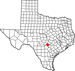
Location of Comal County in Texas
This is a list of the National Register of Historic Places listings in Comal County, Texas.
This is intended to be a complete list of properties and districts listed on the National Register of Historic Places in Comal County, Texas. The locations of National Register properties and districts (at least for all showing latitude and longitude coordinates below) may be seen in a map by clicking on "Map of all coordinates".[1]
- This National Park Service list is complete through NPS recent listings posted December 2, 2016.[2]
| [3] |
Name on the Register[4] |
Image |
Date listed[5] |
Location |
City or town |
Description |
|---|
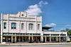
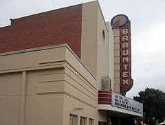
| 1 |
Brauntex Theater |
|
000000002008-03-24-0000March 24, 2008
(#08000240) |
290 W. San Antonio
29°42′05″N 98°07′35″W / 29.701319°N 98.126458°W / 29.701319; -98.126458 (Brauntex Theater) |
New Braunfels |
|
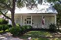
| 2 |
Andreas Breustedt House |
|
000000001982-07-22-0000July 22, 1982
(#82004497) |
1370 Church Hill Dr.
29°42′33″N 98°05′47″W / 29.709164°N 98.096411°W / 29.709164; -98.096411 (Andreas Breustedt House) |
New Braunfels |
|
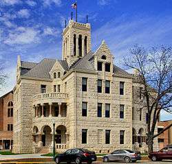
| 3 |
Comal County Courthouse |
|
000000001976-12-12-0000December 12, 1976
(#76002017) |
N. Sequin Ave.
29°42′12″N 98°07′29″W / 29.703333°N 98.124722°W / 29.703333; -98.124722 (Comal County Courthouse) |
New Braunfels |
|
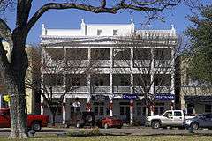
| 4 |
Comal Hotel and Klein-Kuse House |
|
000000001986-06-26-0000June 26, 1986
(#86001373) |
295 E. San Antonio and 165 Market St.
29°42′17″N 98°07′25″W / 29.704722°N 98.123611°W / 29.704722; -98.123611 (Comal Hotel and Klein-Kuse House) |
New Braunfels |
|
| 5 |
Comal Power Plant |
|
000000002004-08-20-0000August 20, 2004
(#04000895) |
Jct. of Landa Rd. and Landa Park Dr.
29°42′23″N 98°07′57″W / 29.706389°N 98.132431°W / 29.706389; -98.132431 (Comal Power Plant) |
New Braunfels |
|
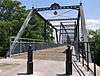
| 6 |
Faust Street Bridge |
|
000000002009-03-17-0000March 17, 2009
(#09000138) |
Connecting Faust and Porter Streets at the Guadalupe River
29°41′48″N 98°06′25″W / 29.696667°N 98.106944°W / 29.696667; -98.106944 (Faust Street Bridge) |
New Braunfels |
Historic Bridges of Texas MPS
|
| 7 |
First Protestant Church |
|
000000001971-07-14-0000July 14, 1971
(#71000926) |
296 S. Seguin St.
29°42′03″N 98°07′21″W / 29.700833°N 98.1225°W / 29.700833; -98.1225 (First Protestant Church) |
New Braunfels |
|
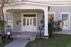
| 8 |
Carl W. A. Groos House |
|
000000002000-08-17-0000August 17, 2000
(#00000884) |
228 S. Seguin St.
29°42′05″N 98°07′22″W / 29.70125°N 98.122708°W / 29.70125; -98.122708 (Carl W. A. Groos House) |
New Braunfels |
|
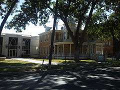
| 9 |
Gruene Historic District |
|
000000001975-04-21-0000April 21, 1975
(#75001962) |
Both sides of Seguin, New Braunfels, and Austin Sts.
29°44′20″N 98°06′12″W / 29.738889°N 98.103333°W / 29.738889; -98.103333 (Gruene Historic District) |
Gruene |
|
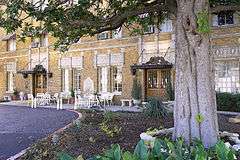
| 10 |
Guadalupe Hotel |
|
000000001975-03-13-0000March 13, 1975
(#75001963) |
471 Main Plaza
29°42′11″N 98°07′31″W / 29.702986°N 98.125278°W / 29.702986; -98.125278 (Guadalupe Hotel) |
New Braunfels |
|
| 11 |
Holz-Forshage-Krueger Building |
|
000000001997-04-17-0000April 17, 1997
(#97000362) |
472 W. San Antonio St.
29°41′58″N 98°07′40″W / 29.699444°N 98.127778°W / 29.699444; -98.127778 (Holz-Forshage-Krueger Building) |
New Braunfels |
|
| 12 |
Hotel Faust |
|
000000001985-05-02-0000May 2, 1985
(#85000922) |
240 S. Seguin St.
29°42′05″N 98°07′23″W / 29.701389°N 98.122917°W / 29.701389; -98.122917 (Hotel Faust) |
New Braunfels |
|
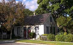
| 13 |
Stephen Klein House |
|
000000001970-08-25-0000August 25, 1970
(#70000743) |
161 S. Seguin St.
29°42′10″N 98°07′26″W / 29.702639°N 98.12375°W / 29.702639; -98.12375 (Stephen Klein House) |
New Braunfels |
|
| 14 |
Lindheimer House |
|
000000001970-08-25-0000August 25, 1970
(#70000744) |
489 Comal Ave.
29°42′02″N 98°07′06″W / 29.700556°N 98.118472°W / 29.700556; -98.118472 (Lindheimer House) |
New Braunfels |
|
| 15 |
Natural Bridge Caverns Sinkhole Site |
|
000000002004-10-29-0000October 29, 2004
(#04001202) |
Address Restricted
29°41′35″N 98°20′33″W / 29.693194°N 98.3425°W / 29.693194; -98.3425 (Natural Bridge Caverns Sinkhole Site) |
Garden Ridge |
|
| 16 |
Saint Joseph's Chapel |
|
000000002014-08-01-0000August 1, 2014
(#14000472) |
6400 FM 482
29°38′50″N 98°13′09″W / 29.647253°N 98.219029°W / 29.647253; -98.219029 (Saint Joseph's Chapel) |
Schertz |
|
See also
References
- ↑ The latitude and longitude information provided in this table was derived originally from the National Register Information System, which has been found to be fairly accurate for about 99% of listings. For about 1% of NRIS original coordinates, experience has shown that one or both coordinates are typos or otherwise extremely far off; some corrections may have been made. A more subtle problem causes many locations to be off by up to 150 yards, depending on location in the country: most NRIS coordinates were derived from tracing out latitude and longitudes off of USGS topographical quadrant maps created under the North American Datum of 1927, which differs from the current, highly accurate WGS84 GPS system used by most on-line maps. Chicago is about right, but NRIS longitudes in Washington are higher by about 4.5 seconds, and are lower by about 2.0 seconds in Maine. Latitudes differ by about 1.0 second in Florida. Some locations in this table may have been corrected to current GPS standards.
- ↑ "National Register of Historic Places: Weekly List Actions". National Park Service, United States Department of the Interior. Retrieved on December 2, 2016.
- ↑ Numbers represent an ordering by significant words. Various colorings, defined here, differentiate National Historic Landmarks and historic districts from other NRHP buildings, structures, sites or objects.
- ↑ National Park Service (2008-04-24). "National Register Information System". National Register of Historic Places. National Park Service.
- ↑ The eight-digit number below each date is the number assigned to each location in the National Register Information System database, which can be viewed by clicking the number.
|
|---|
|
| Topics | |
|---|
|
| Lists by states | |
|---|
|
| Lists by insular areas | |
|---|
|
| Lists by associated states | |
|---|
|
| Other areas | |
|---|
|
-
 Portal Portal
-
 WikiProject WikiProject
|


.jpg)