National Register of Historic Places listings in Coahoma County, Mississippi
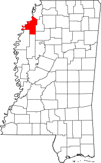
Location of Coahoma County in Mississippi
This is a list of the National Register of Historic Places listings in Coahoma County, Mississippi.
This is intended to be a complete list of the properties and districts on the National Register of Historic Places in Coahoma County, Mississippi, United States. Latitude and longitude coordinates are provided for many National Register properties and districts; these locations may be seen together in a map.[1]
There are 21 properties and districts listed on the National Register in the county.
- This National Park Service list is complete through NPS recent listings posted December 16, 2016.[2]
Current listings
| [3] | Name on the Register[4] | Image | Date listed[5] | Location | City or town | Description |
|---|---|---|---|---|---|---|
| 1 | Barner Site (22CO542) | Upload image | (#84002129) |
Address Restricted |
Clarksdale | |
| 2 | Bobo Senior High School Building | Upload image | (#08000196) |
131 School St. 34°11′57″N 90°34′43″W / 34.199167°N 90.578611°W |
Clarksdale | |
| 3 | Carson Mounds | Upload image | (#79003382) |
Northeastern quarter of the northwestern quarter of Section 24, Township 28 North, Range 5 West[6]:51 34°17′37″N 90°40′17″W / 34.293611°N 90.671389°W |
Clarksdale | |
| 4 | John Clark House | Upload image | (#03000589) |
211 Clark St. 34°12′23″N 90°34′28″W / 34.206389°N 90.574444°W |
Clarksdale | |
| 5 | Clarksdale Historic District | Upload image | (#09000763) |
Roughly bounded by the Sunflower River, 10th St., DeSoto Ave., and Clark St. 34°11′55″N 90°34′10″W / 34.198564°N 90.569381°W |
Clarksdale | |
| 6 | Rufus Davis Site | Upload image | (#78001597) |
Northeastern quarter of the northeastern quarter of Section 5, Township 27 North, Range 4 West[6]:53 34°14′54″N 90°37′32″W / 34.248333°N 90.625556°W |
Clarksdale | |
| 7 | Dickerson Site (22CO502) | Upload image | (#86002323) |
Address Restricted |
Friars Point | |
| 8 | Friars Point Historic District | 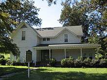 |
(#98001608) |
Along 2nd St. 34°22′20″N 90°38′14″W / 34.372222°N 90.637222°W |
Friars Point | |
| 9 | Humber Site | Upload image | (#75001043) |
Address Restricted |
Farrel | |
| 10 | New Alcazar Hotel | 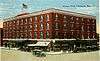 |
(#94000646) |
127 3rd St. 34°12′05″N 90°34′25″W / 34.201389°N 90.573611°W |
Clarksdale | |
| 11 | Oliver Site | Upload image | (#74001061) |
Northwestern quarter of the northwestern quarter of Section 10, Township 25, Range 4 West[6]:53 34°03′28″N 90°36′14″W / 34.057778°N 90.603889°W |
Clarksdale | |
| 12 | Parchman Place Site | Upload image | (#73001005) |
Southwestern quarter of the northwestern quarter of Section 30, Township 29 North, Range 3 West[6]:51 34°21′34″N 90°33′00″W / 34.359444°N 90.550000°W |
Coahoma | |
| 13 | Prairie Plantation House | Upload image | (#94001305) |
1545 Old River Rd. 34°18′22″N 90°39′12″W / 34.306111°N 90.653333°W |
Clarksdale | |
| 14 | Salomon (Salmon) Site | Upload image | (#84002134) |
Northeastern quarter of the northeastern quarter of Section 22, Township 29 North, Range 3 West[6]:51 34°22′39″N 90°29′24″W / 34.377500°N 90.490000°W |
Coahoma | |
| 15 | Spendthrift Site (22CO520) | Upload image | (#86002330) |
Northwestern quarter of the northwestern quarter of Section 13, Township 26 North, Range 3 West[6]:53 34°07′44″N 90°27′51″W / 34.128889°N 90.464167°W |
Mattson | |
| 16 | Sunflower Landing | Upload image | (#91001422) |
Address Restricted |
Rena Lara | |
| 17 | Wilsford | Upload image | (#74001062) |
Address Restricted |
Lula | |
| 18 | Woolworth Building | Upload image | (#09000110) |
207 Yazoo Ave. 34°12′10″N 90°34′25″W / 34.202794°N 90.573708°W |
Clarksdale | |
| 19 | WROX Building |  |
(#02000854) |
257 Delta Ave. 34°12′05″N 90°34′29″W / 34.201389°N 90.574722°W |
Clarksdale | |
| 20 | Yazoo and Mississippi Valley Passenger Depot | 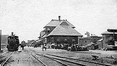 |
(#95001194) |
1 Blues Alley 34°12′03″N 90°34′15″W / 34.200833°N 90.570833°W |
Clarksdale | Later the Illinois Central |
| 21 | Yazoo Pass Levee | Upload image | (#73001006) |
Near Moon Lake on Mississippi Highway 1 34°26′57″N 90°33′02″W / 34.449167°N 90.550556°W |
Moon Lake |
See also
| Wikimedia Commons has media related to National Register of Historic Places in Coahoma County, Mississippi. |
- List of National Historic Landmarks in Mississippi
- National Register of Historic Places listings in Mississippi
References
- ↑ The latitude and longitude information provided in this table was derived originally from the National Register Information System, which has been found to be fairly accurate for about 99% of listings. For about 1% of NRIS original coordinates, experience has shown that one or both coordinates are typos or otherwise extremely far off; some corrections may have been made. A more subtle problem causes many locations to be off by up to 150 yards, depending on location in the country: most NRIS coordinates were derived from tracing out latitude and longitudes off of USGS topographical quadrant maps created under the North American Datum of 1927, which differs from the current, highly accurate WGS84 GPS system used by most on-line maps. Chicago is about right, but NRIS longitudes in Washington are higher by about 4.5 seconds, and are lower by about 2.0 seconds in Maine. Latitudes differ by about 1.0 second in Florida. Some locations in this table may have been corrected to current GPS standards.
- ↑ "National Register of Historic Places: Weekly List Actions". National Park Service, United States Department of the Interior. Retrieved on December 16, 2016.
- ↑ Numbers represent an ordering by significant words. Various colorings, defined here, differentiate National Historic Landmarks and historic districts from other NRHP buildings, structures, sites or objects.
- ↑ National Park Service (2009-03-13). "National Register Information System". National Register of Historic Places. National Park Service.
- ↑ The eight-digit number below each date is the number assigned to each location in the National Register Information System database, which can be viewed by clicking the number.
- 1 2 3 4 5 6 Phillips, Philip, et al. Archaeological Survey in the Lower Mississippi Alluvial Valley 1940-1947. Reprint ed. Tuscaloosa: U of Alabama P, 2003.
| Topics | |
|---|---|
| Lists by states |
|
| Lists by insular areas | |
| Lists by associated states | |
| Other areas | |
| |
Municipalities and communities of Coahoma County, Mississippi, United States | ||
|---|---|---|
| City | | |
| Towns | ||
| CDP | ||
| Other unincorporated communities | ||
| Ghost towns | ||
| Footnotes | ‡This populated place also has portions in an adjacent county or counties | |
This article is issued from Wikipedia - version of the 10/28/2016. The text is available under the Creative Commons Attribution/Share Alike but additional terms may apply for the media files.