| [3] |
Name on the Register |
Image |
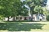
Date listed[4] |
Location |
City or town |
Description |
|---|
| 1 |
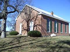
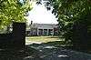
Antioch Christian Church |
Upload image |
000000001979-08-01-0000August 1, 1979
(#79003566) |
Off Muddy Creek Rd. at Four Mile Creek and Stone Branch
37°54′28″N 84°10′06″W / 37.907778°N 84.168333°W / 37.907778; -84.168333 (Antioch Christian Church) |
Winchester |
|
| 2 |
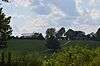
Boone Creek Rural Historic District |
Upload image |
000000001994-08-19-0000August 19, 1994
(#94000839) |
Roughly bounded by Interstate 75, Cleveland Rd., Athens-Boonesboro Rd. and Grimes Rd.
37°55′02″N 84°19′36″W / 37.91721°N 84.32662°W / 37.91721; -84.32662 (Boone Creek Rural Historic District) |
Lexington |
Extends into Fayette County
|
| 3 |
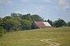
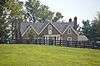
Boot Hill Farm |
|
000000001985-03-01-0000March 1, 1985
(#85000374) |
Athens-Boonesboro Pike (KY 418)
37°55′53″N 84°20′22″W / 37.931389°N 84.339444°W / 37.931389; -84.339444 (Boot Hill Farm) |
Athens |
|
| 4 |
Brock House |
Upload image |
000000001979-08-01-0000August 1, 1979
(#79003567) |
Off Red River Rd.
37°52′09″N 84°06′11″W / 37.869167°N 84.103056°W / 37.869167; -84.103056 (Brock House) |
Bloomingdale |
|
| 5 |
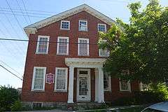
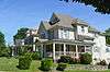
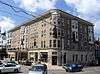
Brown-Proctoria Hotel |
|
000000001977-07-29-0000July 29, 1977
(#77000609) |
Main St. and Lexington Ave.
37°59′28″N 84°10′42″W / 37.991111°N 84.178333°W / 37.991111; -84.178333 (Brown-Proctoria Hotel) |
Winchester |
|
| 6 |
Capt. Robert V. Bush House |
|
000000001979-08-01-0000August 1, 1979
(#79003568) |
Combs Ferry Rd.
37°58′05″N 84°17′22″W / 37.968056°N 84.289444°W / 37.968056; -84.289444 (Capt. Robert V. Bush House) |
Becknerville |
|
| 7 |
W. Bush-Dykes House |
|
000000001979-08-01-0000August 1, 1979
(#79003569) |
U.S. Route 227
37°55′02″N 84°15′26″W / 37.917222°N 84.257222°W / 37.917222; -84.257222 (W. Bush-Dykes House) |
Forest Grove |
|
| 8 |
Bybee House |
Upload image |
000000001979-08-01-0000August 1, 1979
(#79003570) |
Bybee Rd.
37°54′55″N 84°11′05″W / 37.915278°N 84.184722°W / 37.915278; -84.184722 (Bybee House) |
Winchester |
|
| 9 |
Henry W. Calmes House |
Upload image |
000000001979-08-01-0000August 1, 1979
(#79003571) |
U.S. Route 227
37°58′45″N 84°18′51″W / 37.979167°N 84.314167°W / 37.979167; -84.314167 (Henry W. Calmes House) |
Winchester |
|
| 10 |
Tarleton Chiles House |
|
000000001979-08-01-0000August 1, 1979
(#79003598) |
Jones Nursery Rd.
37°57′33″N 84°17′18″W / 37.959167°N 84.288333°W / 37.959167; -84.288333 (Tarleton Chiles House) |
Becknerville |
|
| 11 |
Civil War Fort at Boonesboro |
Upload image |
000000002003-06-18-0000June 18, 2003
(#03000262) |
0.6 miles north of Ford, west of Fort Hampton Rd.
37°53′24″N 84°15′32″W / 37.89°N 84.258889°W / 37.89; -84.258889 (Civil War Fort at Boonesboro) |
Ford |
|
| 12 |
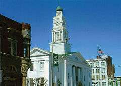
Clark County Court House |
|
000000001974-08-07-0000August 7, 1974
(#74000858) |
Main St.
37°59′34″N 84°10′41″W / 37.992778°N 84.178056°W / 37.992778; -84.178056 (Clark County Court House) |
Winchester |
|
| 13 |
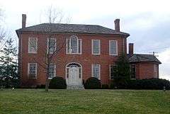
Gov. James A. Clark Mansion |
|
000000001974-06-13-0000June 13, 1974
(#74000859) |
Burns Ave. and Belmont St.
37°59′20″N 84°11′16″W / 37.988889°N 84.187778°W / 37.988889; -84.187778 (Gov. James A. Clark Mansion) |
Winchester |
|
| 14 |
William Clinkenbeard House |
|
000000001980-11-20-0000November 20, 1980
(#80001497) |
Old Paris Pike
38°02′48″N 84°10′42″W / 38.046667°N 84.178333°W / 38.046667; -84.178333 (William Clinkenbeard House) |
Winchester |
|
| 15 |
Colby Tavern |
|
000000001979-08-01-0000August 1, 1979
(#79003572) |
Junction of Colby and Becknerville Rds.
37°59′34″N 84°15′51″W / 37.992778°N 84.264167°W / 37.992778; -84.264167 (Colby Tavern) |
Winchester |
|
| 16 |
Corinth Christian Methodist Episcopal Church |
|
000000002007-07-11-0000July 11, 2007
(#07000678) |
1180 L E Junction Rd.
37°59′54″N 84°03′30″W / 37.998333°N 84.058333°W / 37.998333; -84.058333 (Corinth Christian Methodist Episcopal Church) |
Winchester |
|
| 17 |
Couchman House |
Upload image |
000000001979-08-01-0000August 1, 1979
(#79003573) |
Off Old Boonesboro Rd.
37°57′20″N 84°10′26″W / 37.955556°N 84.173889°W / 37.955556; -84.173889 (Couchman House) |
Winchester |
|
| 18 |
Frances Cullom, Jr. House |
Upload image |
000000001979-08-01-0000August 1, 1979
(#79003574) |
Muddy Creek Rd.
37°55′08″N 84°09′50″W / 37.918889°N 84.163889°W / 37.918889; -84.163889 (Frances Cullom, Jr. House) |
Winchester |
|
| 19 |
Elkin House |
Upload image |
000000001979-08-01-0000August 1, 1979
(#79003576) |
Off U.S. Route 227
37°56′19″N 84°13′17″W / 37.938611°N 84.221389°W / 37.938611; -84.221389 (Elkin House) |
Winchester |
|
| 20 |
Achilles Eubank House |
Upload image |
000000001979-08-01-0000August 1, 1979
(#79003577) |
Elkin Rd.
37°54′25″N 84°12′37″W / 37.906944°N 84.210278°W / 37.906944; -84.210278 (Achilles Eubank House) |
Winchester |
|
| 21 |
Jesse Fishback House |
Upload image |
000000001979-08-01-0000August 1, 1979
(#79003578) |
Off Combs Ferry Rd.
37°58′50″N 84°18′56″W / 37.980556°N 84.315556°W / 37.980556; -84.315556 (Jesse Fishback House) |
Becknerville |
|
| 22 |
John Gibbs House |
Upload image |
000000001979-08-01-0000August 1, 1979
(#79003580) |
Fox-Quisenberry Rd.
37°56′31″N 84°04′00″W / 37.941944°N 84.066667°W / 37.941944; -84.066667 (John Gibbs House) |
Pilot View |
|
| 23 |
David Gist House |
Upload image |
000000001979-08-01-0000August 1, 1979
(#79003581) |
Stoner Rd.
38°05′01″N 84°06′47″W / 38.083611°N 84.113056°W / 38.083611; -84.113056 (David Gist House) |
Winchester |
|
| 24 |
Strauder Goff House |
Upload image |
000000001979-08-01-0000August 1, 1979
(#79003582) |
Off Van Meter Rd.
38°02′48″N 84°11′54″W / 38.046667°N 84.198333°W / 38.046667; -84.198333 (Strauder Goff House) |
Winchester |
|
| 25 |
Goshen Primitive Baptist Church |
|
000000001979-08-01-0000August 1, 1979
(#79003583) |
Goshen Rd.
38°01′08″N 84°04′15″W / 38.018889°N 84.070833°W / 38.018889; -84.070833 (Goshen Primitive Baptist Church) |
Winchester |
|
| 26 |
Nathaniel Haggard House |
Upload image |
000000001979-08-01-0000August 1, 1979
(#79003584) |
Off New Boonesborough Rd.
37°57′35″N 84°12′18″W / 37.959722°N 84.205°W / 37.959722; -84.205 (Nathaniel Haggard House) |
Winchester |
|
| 27 |
Jesse Hampton House |
Upload image |
000000001979-08-01-0000August 1, 1979
(#79003585) |
Bybee Rd.
37°55′05″N 84°11′02″W / 37.918056°N 84.183889°W / 37.918056; -84.183889 (Jesse Hampton House) |
Winchester |
|
| 28 |
Gen. Thomas Hart House |
|
000000001979-08-01-0000August 1, 1979
(#79003586) |
Ecton Rd.
38°00′11″N 84°09′14″W / 38.003056°N 84.153750°W / 38.003056; -84.153750 (Gen. Thomas Hart House) |
Winchester |
|
| 29 |
William Hickman House |
|
000000001982-11-24-0000November 24, 1982
(#82001554) |
31 W. Hickman St.
37°59′28″N 84°10′48″W / 37.991111°N 84.180000°W / 37.991111; -84.180000 (William Hickman House) |
Winchester |
|
| 30 |
Hodgkins House |
|
000000001979-08-01-0000August 1, 1979
(#79003587) |
Old Boonesborough Rd.
37°55′52″N 84°14′07″W / 37.931111°N 84.235278°W / 37.931111; -84.235278 (Hodgkins House) |
Winchester |
|
| 31 |
Dailey-Milton Holliday House |
Upload image |
000000001979-08-01-0000August 1, 1979
(#79003575) |
Jones Nursery Rd.
37°57′00″N 84°18′42″W / 37.95°N 84.311667°W / 37.95; -84.311667 (Dailey-Milton Holliday House) |
Becknerville |
|
| 32 |
Hollywood Springs |
Upload image |
000000001979-08-01-0000August 1, 1979
(#79003588) |
Off Kiddville Rd.
37°56′55″N 83°59′10″W / 37.948611°N 83.986111°W / 37.948611; -83.986111 (Hollywood Springs) |
Kiddville |
|
| 33 |
Hood-Tucker House |
|
000000002007-01-04-0000January 4, 2007
(#06001201) |
19 French Ave.
37°59′10″N 84°10′44″W / 37.986111°N 84.178889°W / 37.986111; -84.178889 (Hood-Tucker House) |
Winchester |
|
| 34 |
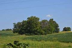
Indian Fort Earthworks (15CK7) |
Upload image |
000000001985-11-14-0000November 14, 1985
(#85002823) |
Address Restricted
|
Goffs Corner |
|
| 35 |
Lampton House |
Upload image |
000000001979-08-01-0000August 1, 1979
(#79003589) |
Muddy Creek Rd.
37°56′57″N 84°08′49″W / 37.949167°N 84.146944°W / 37.949167; -84.146944 (Lampton House) |
Winchester |
|
| 36 |
Alpheus Lewis House |
Upload image |
000000001979-08-01-0000August 1, 1979
(#79003590) |
Off Wades Mill Rd.
38°04′32″N 84°06′54″W / 38.075556°N 84.115°W / 38.075556; -84.115 (Alpheus Lewis House) |
Winchester |
|
| 37 |
Jonathan Bush House |
Upload image |
000000001979-08-01-0000August 1, 1979
(#79003591) |
On Lower Howard's Creek
37°55′44″N 84°16′33″W / 37.928889°N 84.275833°W / 37.928889; -84.275833 (Jonathan Bush House) |
Hootentown |
Originally listed as the Martin House; renamed 2016-08-09.
|
| 38 |
Maj. John Martin House |
|
000000001982-04-29-0000April 29, 1982
(#82002680) |
Basin Springs Rd.
37°59′23″N 84°17′14″W / 37.989722°N 84.287222°W / 37.989722; -84.287222 (Maj. John Martin House) |
Pine Grove |
|
| 39 |
Jonathan Bush Mill |
Upload image |
000000001980-11-20-0000November 20, 1980
(#80001498) |
Address Restricted
|
Winchester |
Originally listed as the Martin-Holder-Bush-Hampton Mill; renamed 2016-08-09.
|
| 40 |
Middle Reaches of Boone Creek Rural Historic District |
Upload image |
000000001996-05-31-0000May 31, 1996
(#96000429) |
Roughly bounded by U.S. Route 421, Jones Nursery, Coombs Ferry, Sulpher Well Rds., and U.S. Route 25
37°57′34″N 84°19′17″W / 37.959444°N 84.321389°W / 37.959444; -84.321389 (Middle Reaches of Boone Creek Rural Historic District) |
Lexington |
Extends into Fayette County
|
| 41 |
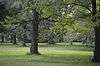
Mound Hill Archeological Site |
|
000000001978-08-25-0000August 25, 1978
(#78001308) |
0.5 miles (0.80 km) west of the Devil's Backbone above Stoner Creek[5]
38°05′49″N 84°08′01″W / 38.096944°N 84.133611°W / 38.096944; -84.133611 (Mound Hill Archeological Site) |
Winchester |
|
| 42 |
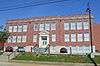
Oliver School |
|
000000002004-08-04-0000August 4, 2004
(#04000795) |
30 Oliver St.
37°59′44″N 84°10′47″W / 37.995556°N 84.179722°W / 37.995556; -84.179722 (Oliver School) |
Winchester |
|
| 43 |
Owen-Gay Farm |
|
000000001997-03-13-0000March 13, 1997
(#97000163) |
Gay Rd., junction with Donaldson Rd. at the Bourbon County line
38°06′24″N 84°06′56″W / 38.106667°N 84.115556°W / 38.106667; -84.115556 (Owen-Gay Farm) |
Winchester |
Extends into Bourbon County
|
| 44 |
Parrish Place |
Upload image |
000000001979-08-01-0000August 1, 1979
(#79003592) |
Todd-Colby Rd.
37°59′31″N 84°19′14″W / 37.991944°N 84.320556°W / 37.991944; -84.320556 (Parrish Place) |
Pine Grove |
|
| 45 |
Col. Edmund Pendleton House |
Upload image |
000000001979-08-01-0000August 1, 1979
(#79003593) |
Van Meter Rd.
38°03′24″N 84°15′09″W / 38.056667°N 84.2525°W / 38.056667; -84.2525 (Col. Edmund Pendleton House) |
Clintonville |
|
| 46 |
Maj. Walter Preston House |
|
000000001979-08-01-0000August 1, 1979
(#79003594) |
Basin Springs Rd.
37°58′45″N 84°17′19″W / 37.979167°N 84.288611°W / 37.979167; -84.288611 (Maj. Walter Preston House) |
Becknerville |
|
| 47 |
Providence Baptist Church |
|
000000001976-05-13-0000May 13, 1976
(#76000864) |
6 miles southwest of Winchester off KY 627
37°56′15″N 84°14′45″W / 37.9375°N 84.245833°W / 37.9375; -84.245833 (Providence Baptist Church) |
Winchester |
|
| 48 |
W. Pruett House |
|
000000001980-11-20-0000November 20, 1980
(#80001499) |
Ecton Rd.
38°00′40″N 84°02′50″W / 38.011111°N 84.047222°W / 38.011111; -84.047222 (W. Pruett House) |
Winchester |
|
| 49 |
J. Quisenberry House |
|
000000001979-08-01-0000August 1, 1979
(#79003596) |
Quisenberry Rd.
37°55′43″N 84°15′04″W / 37.928611°N 84.251111°W / 37.928611; -84.251111 (J. Quisenberry House) |
Forest Grove |
|
| 50 |
Joel Quisenberry House |
Upload image |
000000001979-08-01-0000August 1, 1979
(#79003595) |
Flanagan Station Rd.
37°56′06″N 84°12′57″W / 37.935°N 84.215833°W / 37.935; -84.215833 (Joel Quisenberry House) |
Winchester |
|
| 51 |
Redmond House |
Upload image |
000000001979-08-01-0000August 1, 1979
(#79003597) |
Off U.S. Route 60
38°01′31″N 84°03′42″W / 38.025278°N 84.061667°W / 38.025278; -84.061667 (Redmond House) |
Winchester |
|
| 52 |
Robert Scobee House |
Upload image |
000000001980-11-20-0000November 20, 1980
(#80001500) |
Off U.S. Route 60
38°03′16″N 84°05′28″W / 38.054444°N 84.091111°W / 38.054444; -84.091111 (Robert Scobee House) |
Winchester |
|
| 53 |
South Park Neighborhood |
|
000000002008-06-18-0000June 18, 2008
(#07001253) |
Roughly bounded by Hickman St., an alley east of Kentucky St., the rear of properties facing Highland St., and French Ave.
37°59′16″N 84°10′56″W / 37.987778°N 84.182222°W / 37.987778; -84.182222 (South Park Neighborhood) |
Winchester |
|
| 54 |
Springhill |
|
000000001978-02-17-0000February 17, 1978
(#78001309) |
North of Winchester on Colby Rd.
38°00′30″N 84°17′11″W / 38.008333°N 84.286389°W / 38.008333; -84.286389 (Springhill) |
Winchester |
|
| 55 |
Stipp House |
Upload image |
000000001980-11-20-0000November 20, 1980
(#80001501) |
Van Meter Rd.
38°03′41″N 84°14′58″W / 38.061389°N 84.249444°W / 38.061389; -84.249444 (Stipp House) |
Winchester |
|
| 56 |
F. Taylor Mill |
Upload image |
000000001980-11-20-0000November 20, 1980
(#80001502) |
Address Restricted
|
Winchester |
|
| 57 |
William Taylor House |
Upload image |
000000001979-08-01-0000August 1, 1979
(#79003600) |
Lower Howard's Creek
37°56′16″N 84°15′52″W / 37.937778°N 84.264444°W / 37.937778; -84.264444 (William Taylor House) |
Becknerville |
|
| 58 |
Stanley F. Tebbs House |
|
000000001979-08-01-0000August 1, 1979
(#79003579) |
Todd's Rd.
38°00′02″N 84°17′04″W / 38.000417°N 84.284444°W / 38.000417; -84.284444 (Stanley F. Tebbs House) |
Pine Grove |
|
| 59 |
Thomson Neighborhood District |
|
000000001992-01-17-0000January 17, 1992
(#91001925) |
Roughly bounded by S. Main St., Moundale Ave., Boone Ave., S. Maple St. and W. Hickman St.
37°59′16″N 84°10′56″W / 37.987778°N 84.182222°W / 37.987778; -84.182222 (Thomson Neighborhood District) |
Winchester |
|
| 60 |
Upper Reaches of Boone Creek Rural Historic District |
|
000000002009-11-27-0000November 27, 2009
(#09000569) |
Upper Boone Creek vicinity
38°00′14″N 84°18′14″W / 38.004°N 84.304°W / 38.004; -84.304 (Upper Reaches of Boone Creek Rural Historic District) |
Winchester |
|
| 61 |
Van Meter Distillery |
|
000000001979-08-01-0000August 1, 1979
(#79003599) |
Van Meter Rd.
38°02′16″N 84°12′52″W / 38.037778°N 84.214444°W / 38.037778; -84.214444 (Van Meter Distillery) |
Winchester |
|
| 62 |
Victory Heights Elementary School |
|
000000002004-08-04-0000August 4, 2004
(#04000796) |
160 Maryland Ave.
38°00′05″N 84°11′39″W / 38.001389°N 84.194167°W / 38.001389; -84.194167 (Victory Heights Elementary School) |
Winchester |
|
| 63 |
Vinewood |
|
000000001977-08-12-0000August 12, 1977
(#77000610) |
4 miles northeast of Winchester on U.S. Route 60
38°02′07″N 84°07′35″W / 38.035278°N 84.126389°W / 38.035278; -84.126389 (Vinewood) |
Winchester |
|
| 64 |
Wade Farmstead |
|
000000001979-08-01-0000August 1, 1979
(#79003601) |
Donaldson Rd.
38°06′26″N 84°05′07″W / 38.107222°N 84.085278°W / 38.107222; -84.085278 (Wade Farmstead) |
Winchester |
|
| 65 |
Winchester Downtown Commercial District |
|
000000001982-04-28-0000April 28, 1982
(#82002681) |
Roughly bounded by railroad tracks, KY 627, and Maple and Highland Sts.
37°59′34″N 84°10′38″W / 37.992778°N 84.177222°W / 37.992778; -84.177222 (Winchester Downtown Commercial District) |
Winchester |
|
| 66 |
Woodford-Fishback-Venable Farm |
|
000000002008-07-08-0000July 8, 2008
(#08000655) |
5696 Combs Ferry Rd.
37°56′21″N 84°17′05″W / 37.93914°N 84.28461°W / 37.93914; -84.28461 (Woodford-Fishback-Venable Farm) |
Winchester |
|
.jpg)